Uturoa
| Uturoa | |
|---|---|
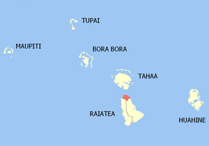 Location of the commune (in red) within the Windward Islands | |
| Coordinates: 16°43′52″S 151°26′35″W / 16.731°S 151.443°WCoordinates: 16°43′52″S 151°26′35″W / 16.731°S 151.443°W | |
| Country | France |
| Overseas collectivity | French Polynesia |
| Government | |
| • Mayor | Sylviane TEROOATEA |
| Area | 16 km2 (6 sq mi) |
| Population (August 2007 census)1 | 3,778 |
| • Density | 240/km2 (610/sq mi) |
| INSEE/Postal code | 98758 / 98735 |
| Elevation | 0–479 m (0–1,572 ft) |
| 1 Population without double counting: residents of multiple communes (e.g., students and military personnel) only counted once. | |
Uturoa is a commune (municipality) of French Polynesia, an overseas territory of France in the Pacific Ocean. The commune of Uturoa is located on the island of Raiatea, in the administrative subdivision of the Leeward Islands of which Uturoa is the administrative capital. The Leeward Islands are themselves part of the Society Islands. Uturoa is the main port of Raiatea Island. At the August 2007 census the urban area of Uturoa had 8,735 inhabitants, 3,778 of which lived in the commune of Uturoa proper. Uturoa is about 200 km (120 mi) northwest of Papeete, the Tahitian capital.
Transport
Raiatea Airport serves the island of Raiatea. The airport is located in eastern Uturoa and many of the islanders come here to travel to different islands. Raiatea Airport has one runway and Air Tahiti is the main airline at the airport. The runway is asphalt and stretches all the way to the eastern side of the island. If the residents want to make an international flight, they would take Air Tahiti to Faa'a International Airport in Faaa. Sometimes ferries leave Raiatea and sail northward toward nearby Tahaa. Other ferries sail to Vaitape/Bora Bora or Tahiti.

History
Uturoa was first settled by early Polynesians coming from Southeast Asia. When the settlers first arrived, they had built houses of branches and grass. Fish, bananas, and apples were the main food that the early Polynesians ate. They hunted fish by using spears and sticks. First European that recorded its sight was Pedro Fernandez de Quirós in 1606; it was charted as Fugitiva.[1] During the 1700s, Captain James Cook had arrived in Tahiti and many more French Polynesian islands to map most of the Pacific Ocean. Later on, Charles Darwin had come on his expedition. He explored Moorea and other Society Islands. Don the Beachcomber had lived here some of his life. Uturoa had a major population growth during the 1940s.
Uturoa harbour
Container ships and ferries are found throughout the harbour. The ferries sail to other Society Islands such as Bora Bora and Moorea. The harbour will always remain relatively small because of the limited coast. The container ships bring in containers and put them into a special area. The containers have come from other countries.
Parks and recreation
Uturoa has some parks near the harbour. The closest one to the harbour is the Uturoa coastal park. The parks on the mountains close to Uturoa have views of the harbour and the city. School parks are found throughout Raiatea and usually have open grass spaces.
Geography
Uturoa is the northernmost point of Raiatea and has a view of Bora Bora, Tahaa, and Huahine. The commune is about 5 ft (1.5 m) above sea level on average. The mountains of Uturoa are not far inland and sometimes touch the coast and form coast ranges. Uturoa is situated between the small pass of Tahaa and the forest-covered mountains of Raiatea.
Beaches
The beaches of Uturoa can be black sand at some parts due to past volcanic eruptions. Parks have been created inland from the beach and Tahitian dancers dance in the spaces. The beaches stop at one point and then the coast is filled with cranes and container ships.
Nearby communes
Uturoa is part of the Raiatea commune. There are 2 other districts that make up Raiatea. The Huahine commune is about 50 km (31 mi) away from Raiatea and is home of Fare, a large commune. Tahaa is just across the pass. Vaitape and Anau of Bora Bora can be seen from Uturoa.
Sports
Uturoa is close to Teahupo'o(~270km) which is a district of Tahiti. Teahupoo is close to a reef break which causes enormous swells, ideal for the World Championship Tour of surfing. One of the champions is Ben Severson.
Other major sports are football and basketball. Football is played in the school fields.
See also
References
- ↑ Burney, James A chronological history of the discoveries in the South Sea or Pacific Ocean London, 1803, vII, p.326.
| Wikimedia Commons has media related to Uturoa. |