Valsavarenche
| Valsavarenche | ||
|---|---|---|
| Comune | ||
| Comune di Valsavarenche Commune de Valsavarenche | ||
 | ||
| ||
 Valsavarenche Location of Valsavarenche in Italy | ||
| Coordinates: 45°35′32″N 7°12′28″E / 45.59222°N 7.20778°E | ||
| Country | Italy | |
| Region | Valle d'Aosta | |
| Province / Metropolitan city | none | |
| Frazioni | Bois-de-Clin, Le Loup, Terre, Créton, Dégioz (chef-lieu), Eaux-Rousses, Fénille, Bien, Breuil, Maisonnasse, Pessey, Pont, Rovenaud, Tignet | |
| Government | ||
| • Mayor | Giuseppe Dupont | |
| Area | ||
| • Total | 139 km2 (54 sq mi) | |
| Elevation | 1,541 m (5,056 ft) | |
| Population (31 December 2014)[1] | ||
| • Total | 164 | |
| • Density | 1.2/km2 (3.1/sq mi) | |
| Demonym(s) | Valsavareins | |
| Time zone | CET (UTC+1) | |
| • Summer (DST) | CEST (UTC+2) | |
| Postal code | 11010 | |
| Dialing code | 0165 | |
| Patron saint | Our Lady of Mount Carmel | |
| Saint day | 16 July | |
| Website | Official website | |
.svg.png)
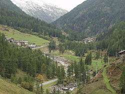
Valsavarenche (known as Valsavara under fascist rule from 1939 to 1946, and as Valsavaranche from 1946 to 1976) is a comune in the Aosta Valley, northern Italy. It is part of the Unité des communes valdôtaines du Grand-Paradis.
References
This article is issued from Wikipedia - version of the 9/22/2016. The text is available under the Creative Commons Attribution/Share Alike but additional terms may apply for the media files.