Rhêmes-Notre-Dame
| Rhêmes-Notre-Dame | |
|---|---|
| Comune | |
| Comune di Rhêmes-Notre-Dame Commune de Rhêmes-Notre-Dame | |
 | |
 Rhêmes-Notre-Dame Location of Rhêmes-Notre-Dame in Italy | |
| Coordinates: 45°34′11.17″N 7°7′5.16″E / 45.5697694°N 7.1181000°ECoordinates: 45°34′11.17″N 7°7′5.16″E / 45.5697694°N 7.1181000°E | |
| Country | Italy |
| Region | Valle d'Aosta |
| Province / Metropolitan city | none |
| Frazioni | Artalle, Brenand, Bruil, Carré, Chanavey, Chaudanne, Oreiller, Pellaud, Pont, Thumel |
| Area | |
| • Total | 86 km2 (33 sq mi) |
| Elevation | 1,725 m (5,659 ft) |
| Population (31 December 2006) | |
| • Total | 128 |
| • Density | 1.5/km2 (3.9/sq mi) |
| Demonym(s) | Rhêmeins |
| Time zone | CET (UTC+1) |
| • Summer (DST) | CEST (UTC+2) |
| Postal code | 11010 |
| Dialing code | 0165 |
| Saint day | 2 July |
| Website | Official website |
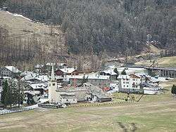
Rhêmes-Notre-Dame is a town and comune in the Aosta Valley region of north-west Italy.
Geography
Rhemes-Notre-Dame is a mountain village located in a valley called "Val di Rhemes". It is part of Gran Paradiso National Park.[1] It is surrounded by mountains and glaciers. Despite the presence of some hotels and downhill slopes it still is a natural place with a rural architectural structure.
Climate
Because of its altitude, winters are cold and snowy, while summers are fresh. Temperatures vary from a minimum value of −15 °C (5 °F) during winters to a maximun value of 22 to 23 °C (72 to 73 °F) during summers.[2]
Economy
The economy of Rhêmes-Notre-Dame is based on skiing during winters and mountain biking and excursions during summers. However, there still are some agricultural activities like cattle breeding that characterized the past of this place.
Twin towns — Sister cities
Rhêmes-Notre-Dame is twinned with:
-
 Solarolo, Italy (1999)