Vattavada
| Vattavada വട്ടവട | |
|---|---|
| Village | |
|
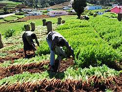
Vegetable farm | |
| Coordinates: 10°11′0″N 77°15′24″E / 10.18333°N 77.25667°ECoordinates: 10°11′0″N 77°15′24″E / 10.18333°N 77.25667°E | |
| Country |
|
| State | Kerala |
| District | Idukki |
| Talukas | Devikulam |
| Population (2001) | |
| • Total | 4,000 |
| Languages | |
| • Official | Malayalam |
| Time zone | IST (UTC+5:30) |
| PIN | 685615 |
| Telephone code | 04865 |
| Vehicle registration | KL-68 |
| Sex ratio | 955:1000 ♂/♀ |
| Literacy | 78% |
| Climate | heavy cool (Köppen) |
| Website |
www |
Vattavada is a village in Idukki district in the state of Kerala, India.[1]
Geography and climate
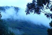
Vattavada is a virtually rain shadow village, lying in the eastern side of the Western Ghats near to Marayur and north side of Munnar.The region in and around Vattavada varies in height from 1,450 meters (4,760 ft) to 2,695 meters (8,842 ft) above mean sea level. Vattavada enjoys a salubrious climate. The temperature ranges between 5 °C (41 °F) and 20 °C (68 °F) in winter and 12 °C (54 °F) and 18 °C (64 °F) in summer. Temperatures as low as −4 °C (25 °F) have been recorded in the border region of Vattavada.[2] The mean maximum daily temperature is at its lowest during the monsoon months with the highest temperature being 19 C.
Crops
Vattavada is known as the market of Kerala, because they are in front of vegetable producing. Vattavada is famous for its wide variety of crops which is not seen on the other parts of Kerala, which includes varieties of apple, orange, strawberry, blackberry, plums, gooseberry, egg fruits, peach and passion fruits, etc.
Flora and fauna
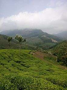
Most of the native flora and fauna of Vattavada have disappeared due to severe habitat fragmentation resultant from the creation of the plantations. However, some species continue to survive and thrive in several protected areas nearby, including the new Kurinjimala Sanctuary to the east, the Chinnar Wildlife Sanctuary, Manjampatti Valley and the Amaravati reserve forest of Indira Gandhi Wildlife Sanctuary to the north east, the Eravikulam National Park and Anamudi Shola National Park to the north, the Pampadum Shola National Park to the south and the proposed Palani Hills National Park to the east. These protected areas are especially known for several threatened and endemic species including Nilgiri tahr, the grizzled giant squirrel, the Nilgiri wood-pigeon, elephant, the gaur, the Nilgiri langur, the sambar, and the neelakurinji (that blossoms only once in twelve years) and special thing is it center for Munnar, Kodaikanal and Marayur [3][4]
References
- ↑ "Census of India : List of villages by Alphabetical : Kerala". Retrieved 2008-12-10.
|first1=missing|last1=in Authors list (help) - ↑ Frost hits plantations in Vattavada.
- ↑ Government of Kerala, Forest and Wildlife Department, Notification No. 36/2006 F&WLD (6 October 2006) retrieved 5/12/2007 Kerala Gazette
- ↑ Mathew Roy (Sep 25, 2006) "Proposal for Kurinjimala sanctuary awaits Cabinet nod" the Hindu, retrieved 5/12/2007 the Hindu