Devikulam
| Devikulam ദേവികുളം | |
|---|---|
| Village | |
|
Photo point | |
 Devikulam  Devikulam Location in Kerala, India | |
| Coordinates: 10°03′46″N 77°06′14″E / 10.062640°N 77.103990°ECoordinates: 10°03′46″N 77°06′14″E / 10.062640°N 77.103990°E | |
| Country |
|
| State | Kerala |
| District | Idukki |
| Government | |
| • Type | Panchayath |
| • Body | Devikulam grama panchayath |
| Area | |
| • Total | 215 km2 (83 sq mi) |
| Population | |
| • Total | 29,734 |
| • Density | 140/km2 (360/sq mi) |
| Languages | |
| • Official | Malayalam |
| Time zone | IST (UTC+5:30) |
| PIN | 685613 |
| Area code(s) | 04865 |
| Vehicle registration | KL-68 |

Devikulam is a small hill station about 5 kilometres (3.1 mi) from Munnar in the Idukki District of the southern state of Kerala, India. It lies 1,800 metres (5,900 ft) above sea level.[1]
Etymology
The name Devikulam is a conjunction of the words Devi, from the goddess Devi and kulam, meaning pond.
Legend
According to legend, the goddess Sita Devi of the Ramayana epic bathed in the beautiful Devikulam lake waters surrounded by lush, green hills, now named Sita Devi Lake. The lake draws tourists not only because of its sacredness but also for the curative powers of its mineral waters. Most of the inhabitants in this town speak Malayalam and Tamil. Nearby, are the scenic Pallivasal Waterfalls, dense, green tea plantations, and the natural vegetation of slim red and blue and yellow gum trees.[2]
The settlement had a population of approximately 350 people as of 2010
Gallery
 Tea estates
_(13663515803).jpg) Devikulam estate
Devikulam estate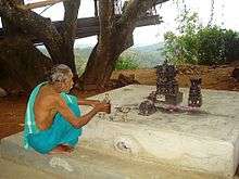 Tribal Temple at Rajakumari
References
- ↑ "Devikulam". Hill Stations in India. Retrieved 2006-10-15.
- ↑ "Devikulam- Kerala". Hill Resorts in India. Retrieved 2006-10-15.
External links
| Wikimedia Commons has media related to Devikulam. |