Vermilion Township, Erie County, Ohio
| Vermilion Township, Erie County, Ohio | |
|---|---|
| Township | |
|
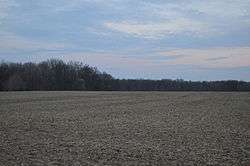
Agricultural scene on Sperry Road | |
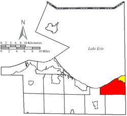 Location of Vermilion Township (red) in Erie County, adjacent to the city of Vermilion | |
| Coordinates: 41°24′26″N 82°23′13″W / 41.40722°N 82.38694°WCoordinates: 41°24′26″N 82°23′13″W / 41.40722°N 82.38694°W | |
| Country | United States |
| State | Ohio |
| County | Erie |
| Area | |
| • Total | 22.2 sq mi (57.5 km2) |
| • Land | 19.9 sq mi (51.6 km2) |
| • Water | 2.3 sq mi (6.0 km2) |
| Elevation[1] | 620 ft (189 m) |
| Population (2010) | |
| • Total | 4,945 |
| • Density | 248/sq mi (95.9/km2) |
| Time zone | Eastern (EST) (UTC-5) |
| • Summer (DST) | EDT (UTC-4) |
| ZIP code | 44089 |
| Area code(s) | 440 |
| FIPS code | 39-79730[2] |
| GNIS feature ID | 1086071[1] |
| Website |
www |
Vermilion Township is one of the nine townships of Erie County, Ohio, United States. It is part of the Sandusky, Ohio metropolitan statistical area. As of the 2010 census the population was 4,945.[3]
Geography
Located in the northeastern corner of the county along Lake Erie, it borders the following townships:
- Brownhelm Township, Lorain County - east
- Henrietta Township, Lorain County - southeast corner
- Florence Township - south
- Berlin Township - southwest
Part of the city of Vermilion is located in northeastern Vermilion Township along the shoreline of Lake Erie.
Name and history
- It is the only Vermilion Township statewide, although there is a Vermillion Township in Ashland County. (Originally both of these townships had used the same double-L spelling, "Vermillion".)
- Vermilion Township was named from the Vermilion River.[4] This township was established about 1808, and it originally extended westward all the way to the Huron River. However, that western section was later annexed onto Huron Township and Berlin Township. [5]
Government
The township is governed by a three-member board of trustees who are elected in November of odd-numbered years to a four-year term beginning on the following January 1. Two are elected in the year after the presidential election and one is elected in the year before it. There is also an elected township fiscal officer,[6] who serves a four-year term beginning on April 1 of the year after the election, which is held in November of the year before the presidential election. Vacancies in the fiscal officership or on the board of trustees are filled by the remaining trustees.
References
- 1 2 "US Board on Geographic Names". United States Geological Survey. 2007-10-25. Retrieved 2008-01-31.
- ↑ "American FactFinder". United States Census Bureau. Archived from the original on September 11, 2013. Retrieved 2008-01-31.
- ↑ "Geographic Identifiers: 2010 Demographic Profile Data (G001): Vermilion township, Erie County, Ohio". U.S. Census Bureau, American Factfinder. Retrieved March 10, 2016.
- ↑ Williams, William W. (1879). History of the Fire Lands, Comprising Huron and Erie Counties, Ohio. Press of Leader Printing Company. p. 440.
- ↑ Williams, William W. (1879). History of the Fire Lands, Comprising Huron and Erie Counties, Ohio. Press of Leader Printing Company.
- ↑ §503.24, §505.01, and §507.01 of the Ohio Revised Code. Accessed 4/30/2009.
External links
Municipalities and communities of Erie County, Ohio, United States | ||
|---|---|---|
| Cities |  | |
| Villages | ||
| Townships | ||
| CDPs | ||
| Unincorporated communities | ||
| Footnotes | ‡This populated place also has portions in an adjacent county or counties | |