Vermont Route 128
| ||||
|---|---|---|---|---|
|
Map of western Vermont with VT 128 highlighted in red | ||||
| Route information | ||||
| Maintained by VTrans | ||||
| Length: | 11.616 mi[1] (18.694 km) | |||
| Major junctions | ||||
| South end: |
| |||
| North end: |
| |||
| Location | ||||
| Counties: | Chittenden, Franklin | |||
| Highway system | ||||
| ||||

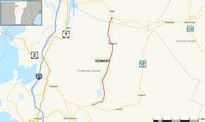
Vermont Route 128 is a 11.616-mile-long (18.694 km) north–south state highway in northwestern Vermont, United States. The southern terminus of the route is at VT 15 in Essex, Chittenden County. Its northern terminus is at VT 104 in Fairfax, Franklin County.
Route description
VT 128 begins at a junction with VT 15 (Center Road) in the Chittenden County town of Essex. VT 128 runs east from VT 15 as a two-lane commercial street through downtown Essex, soon leaving the center of town. The route begins running northeast through Essex, the farms and crossing the Browns River. At Weed Road, VT 128 turns northeast even further, paralleling the Browns River through rural Essex, passing some local residences. The route turns north on Osgood Hill Road, winding along the river. Near Pettingill Road, the route bends southeast.[2]
Crossing into the town of Westford, VT 128 turns northeast through dense woods of town. The woods recede for local farms and fields, and the route soon makes an elongated curve into the center of Westford. Crossing the Browns River, VT 128, turning west near Cambridge Road, serves as the main road through the hamlet. After Brookside Road, the route turns northwest, passing through the rural sections of Westford. At Woods Hollow Road, VT 128 runs north past Westford–Milton Road, which connects to the village of Milton. The route continues north, crossing the county line into Franklin County.[2]
Now in the town of Fairfax, VT 128 crosses the Browns River, changing names to Browns River Road. The route turns northeast, crossing through more fields and woods before reaching the western end of the hamlet of Fairfax. At the junction with McNail Road, VT 128 turns east onto its right-of-way, changing names with Ramsey Road, reaching a merge with VT 104 (Main Street), which marks the northern terminus of VT 128.[2]
Major intersections
| County | Location[1] | mi[1] | km | Destinations | Notes |
|---|---|---|---|---|---|
| Chittenden | Essex | 0.000 | 0.000 | ||
| Westford | 10.134 | 16.309 | Westford–Milton Road | Connector to the village of Milton | |
| Franklin | Fairfax | 11.616 | 18.694 | ||
| 1.000 mi = 1.609 km; 1.000 km = 0.621 mi | |||||
References
- 1 2 3 Traffic Research Unit (May 2013). "2012 (Route Log) AADTs for State Highways" (PDF). Policy, Planning and Intermodal Development Division, Vermont Agency of Transportation. Retrieved April 22, 2015.
- 1 2 3 Microsoft; Nokia (December 27, 2013). "overview map of Route 128" (Map). Bing Maps. Microsoft. Retrieved December 27, 2013.
External links
| Wikimedia Commons has media related to Vermont Route 128. |