Viedma, Río Negro
| Viedma | ||
|---|---|---|
|
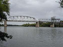
Aerial view of Viedma (top) and Carmen de Patagones. | ||
| ||
 Viedma | ||
| Coordinates: 40°49′39.00″S 62°58′23″W / 40.8275000°S 62.97306°W | ||
| Country |
| |
| Province |
| |
| Department | Adolfo Alsina | |
| Established | 22 March 1779 | |
| Government | ||
| • Intendant | José Luis Foulkes (UCR) | |
| Elevation | 12 m (39 ft) | |
| Population (2012) | ||
| • Total | 54,779 | |
| Time zone | ART (UTC−3) | |
| Climate | BSk | |
| Website | Official website | |


Viedma (Spanish pronunciation: [ˈbjeðma]) is the capital and fourth largest city of the Río Negro Province, in South-Central Argentina. The city has 47,246 inhabitants (2001), and is located on the southern margin of the Negro River, about 30 kilometres off the Atlantic Coast, and 960 km from the city of Buenos Aires on the National Route 3.
History
Together with Carmen de Patagones city across the river in the Buenos Aires Province, it is the oldest settlement in Patagonia, founded by Francisco de Viedma y Narváez under the name of Nuestra Señora del Carmen on 22 April 1779. Originally the two cities were one, both called Carmen de Patagones. The original fort was built on the south side of the river in modern Viedma, but it was destroyed within a few years. A new fort was built on the north side, in the current day Carmen de Patagones. This fort lasted much longer, and the tower still stands today. The town grew here, and eventually expanded back across the river into modern day Viedma. At some point, the town decided to split with the Río Negro as their border.
With the Conquest of the Desert, the city became the capital of all the Argentine Patagonia, and later, when it was divided in further smaller territories, the capital of the Río Negro Territory. Alvaro Barros, the first governor of Río Negro, changed the name of the city to Viedma, in 1879. During severe flooding in 1900, the capital of Río Negro was temporary moved to Choele Choel, but it was quickly restored to Viedma.
During the presidency of Raúl Alfonsín, a proposal was made to move the federal capital from Buenos Aires to Viedma in 1986.[1] This was to reduce congestion in Buenos Aires, to help develop Patagonia, and to promote the development of the interior.[2] A bill to that effect was passed by Congress the following year, but owing to economic problems, the project had stagnated by the end of the Alfonsín administration in 1989.[3]
Economy
The main economical activities in the area of the Valle Inferior are cattle, as well as some agriculture with onion, maize and alfalfa being the most important. However, Viedma is mainly an administrative city, being the capital city of the province.
Transport
The Gobernador Castello Airport (IATA: VDM, ICAO: SAVV) serves flights to Buenos Aires, Neuquén, Bariloche, Puerto Madryn, Trelew, Comodoro Rivadavia, Mar del Plata, and other cities in Argentina. It is located 6 km from the city, and has an average annual traffic of 30,000 passengers. 30 km downstream from Viedma, on the Atlantic shore, the El Cóndor beach resort town (Balneario Massini) is the most visited tourist beach in the area. The Servicios Ferroviarios Patagónico connect with San Carlos de Bariloche.
Climate
Viedma has a cool semi-arid climate (Köppen climate classification BSk). Winters are cool with a July mean of 6.6 °C (43.9 °F) and frosts are common, averaging 9–10 days from June to August.[4] During this time of the year, overcast days are more common, averaging 9–10 days per month although sunny days are fairly common as well.[5] Spring and fall are transition seasons featuring warm daytime temperatures and cool nighttime temperatures and are highly variable with some days reaching above 39 °C (102.2 °F) and below −5 °C (23.0 °F).[5] Summers are hot and dry with a January high of 30.4 °C (86.7 °F) and a low of 14.8 °C (58.6 °F). Humid days are rare owing to the low humidity (around 50%) and a dewpoint temperature of 12 to 13 °C (53.6 to 55.4 °F).[4] Relative humidity is low, averaging 62%, with the summer months being drier than the winter months.[5] The city is windy throughout the entire year with windspeeds ranging from a low of 22.1 kilometres per hour (13.7 mph) to 30.5 kilometres per hour (19.0 mph) in December.[5] On average, Viedma receives 380.0 millimetres (15 in) of precipitation per year with summer months being slightly more wetter than the winter months. Viedma receives 2620 hours of sunshine per year or 57.7% of possible sunshine per year, ranging from a low of 43.5% in July to a high of 69% in March.[4] The highest recorded temperature was 43.7 °C (110.7 °F) on February 18, 1987 while the lowest recorded temperature was −10.8 °C (12.6 °F) on July 4, 1988.[6]
| Climate data for Viedma Airport, Rio Negro, Argentina (1971–1990, extremes 1970–present) | |||||||||||||
|---|---|---|---|---|---|---|---|---|---|---|---|---|---|
| Month | Jan | Feb | Mar | Apr | May | Jun | Jul | Aug | Sep | Oct | Nov | Dec | Year |
| Record high °C (°F) | 42.9 (109.2) |
43.7 (110.7) |
38.5 (101.3) |
33.6 (92.5) |
29.9 (85.8) |
25.2 (77.4) |
25.0 (77) |
28.8 (83.8) |
32.3 (90.1) |
35.4 (95.7) |
39.9 (103.8) |
43.2 (109.8) |
43.7 (110.7) |
| Average high °C (°F) | 29.6 (85.3) |
27.9 (82.2) |
25.0 (77) |
20.8 (69.4) |
16.2 (61.2) |
12.9 (55.2) |
12.7 (54.9) |
15.1 (59.2) |
18.0 (64.4) |
21.0 (69.8) |
24.8 (76.6) |
27.4 (81.3) |
21.0 (69.8) |
| Daily mean °C (°F) | 21.9 (71.4) |
20.8 (69.4) |
17.9 (64.2) |
13.9 (57) |
10.0 (50) |
7.1 (44.8) |
6.8 (44.2) |
8.3 (46.9) |
10.9 (51.6) |
14.2 (57.6) |
17.8 (64) |
20.5 (68.9) |
14.2 (57.6) |
| Average low °C (°F) | 14.5 (58.1) |
13.9 (57) |
11.4 (52.5) |
7.8 (46) |
4.7 (40.5) |
2.2 (36) |
1.9 (35.4) |
2.4 (36.3) |
4.5 (40.1) |
7.1 (44.8) |
10.1 (50.2) |
12.9 (55.2) |
7.8 (46) |
| Record low °C (°F) | 0.5 (32.9) |
2.4 (36.3) |
−0.7 (30.7) |
−4.8 (23.4) |
−5.3 (22.5) |
−8.7 (16.3) |
−10.8 (12.6) |
−7.2 (19) |
−6.7 (19.9) |
−5.0 (23) |
−1.8 (28.8) |
1.4 (34.5) |
−10.8 (12.6) |
| Average precipitation mm (inches) | 36.5 (1.437) |
45.4 (1.787) |
28.2 (1.11) |
35.7 (1.406) |
30.2 (1.189) |
22.5 (0.886) |
24.6 (0.969) |
23.4 (0.921) |
26.7 (1.051) |
29.4 (1.157) |
22.7 (0.894) |
31.0 (1.22) |
356.3 (14.028) |
| Average precipitation days (≥ 0.1 mm) | 6 | 6 | 6 | 6 | 8 | 8 | 8 | 5 | 5 | 7 | 5 | 6 | 76 |
| Average relative humidity (%) | 50.5 | 56.0 | 63.5 | 67.5 | 74.0 | 74.5 | 73.5 | 66.5 | 62.0 | 58.5 | 50.0 | 50.5 | 62.3 |
| Mean monthly sunshine hours | 291.0 | 257.1 | 272.8 | 201.0 | 148.8 | 126.0 | 133.3 | 179.8 | 201.0 | 248.0 | 270.0 | 291.4 | 2,620.2 |
| Percent possible sunshine | 65.0 | 66.0 | 69.0 | 59.0 | 49.0 | 43.5 | 45.0 | 54.5 | 56.0 | 60.0 | 63.0 | 62.0 | 57.7 |
| Source #1: Secretaria de Mineria[4] | |||||||||||||
| Source #2: Oficina de Riesgo Agropecuario (record highs and lows, 1971–present),[6] Servicio Meteorológico Nacional (precipitation days)[7] | |||||||||||||
See also
References
- ↑ An ambitious project that goes back to the ‘80s, Buenos Aires Herald, January 9, 2014
- ↑ Capital Cities/Les Capitales: International Perspectives/Perspectives Internationales, John H. Taylor, Jean G. Lengellé, Caroline Andrew, McGill-Queen's Press, MQUP, 1993, page 150
- ↑ The Strait of Magellan, Michael A. Morris, Martinus Nijhoff Publishers, 1989, page 33
- 1 2 3 4 "Provincia de Rio Negro - Clima Y Meteorologia: Datos Meteorologicos Y Pluviometicos" (in Spanish). Secretaria de Mineria de la Nacion (Argentina). Archived from the original on January 19, 2015. Retrieved October 12, 2015.
- 1 2 3 4 "Statistical Data (1981-1990 Period)" (in Spanish). National Meteorological Service of Argentina. Retrieved August 14, 2012.
- 1 2 "Viedma, Rio Negro". Estadísticas meteorológicas decadiales (in Spanish). Oficina de Riesgo Agropecuario. Retrieved April 14, 2015.
- ↑ "Valores Medios de Temperature y Precipitación-Rio Negro: Viedma" (in Spanish). Servicio Meteorológico Nacional. Retrieved October 12, 2015.
External links
- Municipal information: Municipal Affairs Federal Institute (IFAM), Municipal Affairs Secretariat, Ministry of Interior, Argentina. (Spanish)
- Welcome Viedma (English)
- Viedma and around (Spanish)
- Clasificados Viedma (Spanish)
- Viedma Portal (Spanish)
- Viedma Accommodation Portal (English)
Coordinates: 40°48′S 63°00′W / 40.800°S 63.000°W