Viper Island
 Viper Island Location of Viper Island | |
| Geography | |
|---|---|
| Location | Bay of Bengal |
| Coordinates | 11°39′40″N 92°41′49″E / 11.661°N 92.697°ECoordinates: 11°39′40″N 92°41′49″E / 11.661°N 92.697°E |
| Archipelago | Andaman Islands |
| Adjacent bodies of water | Indian Ocean |
| Total islands | 1 |
| Major islands |
|
| Area | 0.335 km2 (0.129 sq mi)[1] |
| Length | 0.88 km (0.547 mi) |
| Width | 0.50 km (0.311 mi) |
| Coastline | 2.7 km (1.68 mi) |
| Highest elevation | 0 m (0 ft)[2] |
| Administration | |
| District | South Andaman |
| Island group | Andaman Islands |
| Island sub-group | Port Blair Islands |
| Tehsil | Port Blair |
Largest settlement |
Viper Island (RV) |
| Demographics | |
| Demonym | Hindi |
| Population | 0 (2011) |
| Pop. density | 0.00 /km2 (0 /sq mi) |
| Ethnic groups | Hindu, Andamanese |
| Additional information | |
| Time zone | |
| PIN | 744202[3] |
| Telephone code | 031927 [4] |
| Official website |
www |
| ISO Code | IN-AN-00[5] |
| Literacy | 84.4% |
| Avg. summer temperature | 30.2 °C (86.4 °F) |
| Avg. winter temperature | 23.0 °C (73.4 °F) |
| Sex ratio | 1.2♂/♀ |
| unit_pref | Metric |
| Census Code | 35.639.0004 |
| Official Languages | Hindi, English |
Viper Island is an island of the Andaman Islands. It belongs to the South Andaman administrative district, part of the Indian union territory of Andaman and Nicobar Islands.[6] the island is lying 4 km (2 mi) west from Port Blair.
History
Viper Island derives its name from the vessel H.M.S. Viper in which Lt. Archibald Blair came to Andaman and Nicobar Islands in 1789. The vessel, it is believed, met with an accident and its wreckage was found near the island. This small island was the site of the jail where the British used to imprison convicts and political prisoners. It has the ruins of a gallows atop a hillock. The jail was abandoned when the Cellular Jail was constructed in 1906. In any talk about Andaman and its role in the freedom struggle, it is the Cellular Jail that finds frequent mention. But, many years before the Cellular Jail was constructed, it was the jail at Viper Island that was used by the British to inflict the worst form of torture and hardship on those who strove to free the country from the British rule.
The Jail
The need for building a jail there was felt only after the British set up a penal settlement at Port Blair in 1858. Ross Island functioned as the headquarters of the penal settlement. Located near Port Blair, the construction of the Viper Jail was carried out during 1864–67. Lt. Col. Barnet Ford, superintendent of the penal settlement, supervised the work. Initially, a police inspector, a head constable, two sergeants, four class I constables and 30 class II constables were posted, according to materials available at the Cellular Jail. Later on, the strength was raised gradually. Solitary cells, lock-ups, stocks and whipping stands characterized the Viper Jail. Women were among the prisoners there.
The conditions at the jail were such that the place got the notorious name, "Viper Chain Gang Jail". Those who had challenged the might of the British authority were chained together and confined at night by a chain running through coupling of irons around their legs. It was at this jail that members of the Chain Gang were put to hardest labour. Brij Kishore Singh Deo, popularly known as Maharaja Jagannath of Puri, was treated like an ordinary convict and kept in the Viper Jail, where he died in 1879.
The Jail has secured a permanent place in the history of the freedom struggle as it was here that Sher Ali, a Pathan from Peshawar, was hanged after he assassinated Lord Mayo, Indian Viceroy, on February 8, 1872 at Hope Town jetty, opposite Chatham Island. After the construction of the Cellular Jail in 1906, the Viper Jail's importance declined.[7]
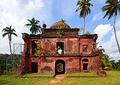
Today, the two-storeyed Jail building stands tumbled to the plinth level except for a portion of the roof with the outer wall dilapidated. But for a few birds which have built their nests inside the tomb of the gallows, only a deafening silence prevails there.
Geography
The island belongs to the Port Blair Islands and lies in the middle of Navy Bay.
Administration
Politically, Viper Island, along neighboring Port Blair Islands, are part of Port Blair Taluk.[8]
Fauna
The island has some vipers and snakes on it.
Tourism
Viper Island is a serene beautiful tourist destination situated near Port Blair's harbour, and can be approached in 20 minutes from the Phoenix Bay jetty. The Harbor Cruise, available daily from the jetty, provides an overall view of different points of the harbor and a trip to this haunted Viper Island. This place is visited by number of tourists as it has multiple attractions with historical importance and also has mesmerizing picnic spots with natural picturesque environments.
Image gallery
 Hilltop Gallows on Viper Island
 Viper Island
References
- ↑ "Islandwise Area and Population - 2011 Census" (PDF). Government of Andaman.
- ↑ "Sailing Directions (enroute) | India and the Bay of Bengal" (PDF) (173). National Geospatial-intelligence Agency, United States Government. 2014. Retrieved 2016-09-23.
- ↑ "A&N Islands - Pincodes". 22 September 2016. Retrieved 22 September 2016.
- ↑ "STD Codes of Andaman and Nicobar". allcodesindia.in. Retrieved 2016-09-23.
- ↑ Registration Plate Numbers added to ISO Code
- ↑ "Village Code Directory: Andaman & Nicobar Islands" (PDF). Census of India. Retrieved 2011-01-16.
- ↑
- ↑ "DEMOGRAPHIC – A&N ISLANDS" (PDF). andssw1.and.nic.in. Retrieved 2016-09-23.
| Wikimedia Commons has media related to Port Blair. |
- T. Ramakrishnan, "Notorious Once, It Stands Shrouded in Silence Now", The Hindu, (Aug 15, 2004)
 Andaman and Nicobar Islands travel guide from Wikivoyage