Volcano Islands
- Not to be confused with volcanic island.
| Native name: 火山列島 | |
|---|---|
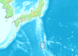 Location in the Pacific | |
| Geography | |
| Location | Pacific Ocean |
| Coordinates | 24°46′N 141°18′E / 24.767°N 141.300°ECoordinates: 24°46′N 141°18′E / 24.767°N 141.300°E |
| Total islands | 3 |
| Area | 32.55 km2 (12.57 sq mi) |
| Administration | |
| Municipality | Ogasawara[1] |
| Demographics | |
| Population | 380 (January 2008) |

The Volcano Islands or Ioretto (火山列島 Kazan Rettō) is a group of three Japanese islands south of the Bonin Islands that belong to the municipality of Ogasawara.[2][3] The islands are all active volcanoes lying atop an island arc that stretches south to the Marianas. They have an area of 32.55 square kilometres (12.57 sq mi) and a population of 380.
Geography
The Volcano Islands are:
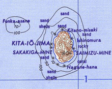
- Kita Iwo Jima (北硫黄島 Kita-Iō-jima or Kita-Iō-tō, literally North Sulphur Island), 5.57 square kilometres (2.15 sq mi), 792 metres (2,598 ft) (Sakaki-ga-mine)
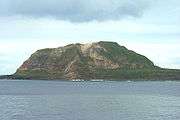
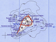
- Iwo Jima (硫黄島 Iō-jima or Iō-tō, literally Sulphur Island) 20.60 square kilometres (7.95 sq mi), 166 metres (545 ft) (Suribachi-yama)
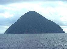
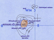
- Minami Iwo Jima (南硫黄島 Minami-Iō-jima or Minami-Iō-tō, literally South Sulphur Island) 3.54 square kilometres (1.37 sq mi), 916 metres (3,005 ft)
Farther north but in the same volcanic arc is:
- Nishino-shima (西之島, literally Western Island), 38 metres (125 ft)[2]
There is a Japan Self-Defense Forces air base on Iwo Jima with a staff of 380. It is located in the village of Minami (Iwo Jima village). Other than that, the islands are uninhabited.
History
The first recorded sighting by Europeans was in October 1543 by Spanish navigator Bernardo de la Torre on board of carrack San Juan de Letrán when trying to return from Sarangani to New Spain.[4] Iwo Jima was charted as Sufre, the old Spanish term for sulphur.
The islands [5]were uninhabited until 1889, when the two northern islands were settled by Japanese settlers from the Izu Islands. They were annexed by Japan in 1891.[2][3]
The population was about 1,100 in 1939, distributed among five settlements: Higashi, Minami, Nishi, Kita and Motoyama (meaning "East", "South", "West", "North" and "Mountain of Origin", or central mountain) on Iwo Jima; and two settlements on Kita Iwo Jima: Ishino-mura ("Ishino village"; Ishino is a surname) and Nishi-mura ("West village"). The municipal administration office was located in Higashi until 1940, when the municipality was integrated into the administration of Ogasawara, Tokyo.
Iwo Jima was the site of the Battle of Iwo Jima in World War II, and the island group came under United States administration. The Volcano Islands were reverted to Japanese administration in 1968.[2]
References
- ↑ 伊豆・小笠原諸島における 情報通信インフラ整備状況の調査 (Survey on improvement conditions of telecommunication infrastructures in Izu-Ogasawara Islands), Kantō Bureau of Telecommunications, retrieved on October 16, 2008.
- 1 2 3 4 "火山列島" [Volcano Islands]. Nihon Daihyakka Zensho (Nipponika) (in Japanese). Tokyo: Shogakukan. 2013. OCLC 153301537. Archived from the original on August 25, 2007. Retrieved 2013-10-09.
- 1 2 "火山列島" [Volcano Islands]. Nihon Rekishi Chimei Taikei (in Japanese). Tokyo: Shogakukan. 2013. OCLC 173191044. Archived from the original on August 25, 2007. Retrieved 2013-10-09.
- ↑ Brand, Donald D. The Pacific Basin: A History of its Geographical Explorations The American Geographical Society (New York, 1967) p.123.
- ↑ Welsch, Bernhard (2004). "Was Marcus Island Discovered by Bernardo de la Torre in 1543?". Journal of Pacific History. 39 (1): 109–122. doi:10.1080/00223340410001684886.
See also
![]() Media related to Volcano Islands at Wikimedia Commons
Media related to Volcano Islands at Wikimedia Commons