Walkerston, Queensland
| Walkerston Queensland | |||||||||||||
|---|---|---|---|---|---|---|---|---|---|---|---|---|---|
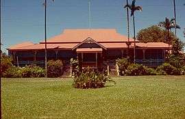 Greenmount Homestead, Walkerston | |||||||||||||
 Walkerston | |||||||||||||
| Coordinates | 21°10′S 149°4′E / 21.167°S 149.067°ECoordinates: 21°10′S 149°4′E / 21.167°S 149.067°E | ||||||||||||
| Population | 3,089 (2011 census)[1] | ||||||||||||
| Postcode(s) | 4751 | ||||||||||||
| Location | |||||||||||||
| LGA(s) | Mackay Regional Council | ||||||||||||
| State electorate(s) | Mirani | ||||||||||||
| Federal Division(s) | Capricornia | ||||||||||||
| |||||||||||||
Walkerston is a town and locality in Mackay Region, Queensland, Australia.[2][3] In the 2011 census, Walkerston had a population of 3,089 people.[1]
Geography
The town is situated on the Peak Downs Highway 14 kilometres (8.7 mi) south-west of Mackay. Walkerston straddles Bakers Creek for about 3 kilometres (1.9 mi).
Palms is a neighbourhood within Walkerston, located to the east of the town (21°10′00″S 149°04′59″E / 21.16667°S 149.08306°E).[4]
History
This town was commonly known as Scrubby Creek from as early as 1866, and sometimes as Baker’s Creek; later these two names were interchangeable with Walkerston and, to a lesser degree, Alsatia. Scrubby Creek was definitely not a nickname for Walkerston; there were no inverted commas included when the words were printed in newspapers or almanacs. The name was well deserved, for the wild bush scrub grew luxuriantly on the banks of Baker’s Creek.
In May 1860, Scots-born John Mackay was only 21 years old when he left Armidale, New South Wales in January 1860 with men, horses and provisions in search of land for cattle runs in north Queensland. They travelled up the east coast, taking a mainly inland route until they came to the junction of Cattle Creek and the Pioneer River, in an area about 15 miles west of present-day Walkerston. They then followed the river, firstly named by Mackay’s companions as the Mackay River but now known as the Pioneer.[5]
The Pioneer Valley railway reached Walkerston from Paget on 10 August 1885. Whilst there was a station building, there was no passenger platform, passengers accessing the trains from the ground.[6]
At the 2006 census, Walkerston had a population of 2,563.[7]
Amenities
The town has two primary schools, a post office, three bars (including a sports club), and a supermarket.
Heritage listings
Walkerston has a number of heritage-listed sites, including:
- Greenmount Road: Greenmount Homestead[8]
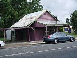
- 13 Dutton Street: Walkerston State Butcher's Shop[9]
References
- 1 2 Australian Bureau of Statistics (31 October 2012). "Walkerston". 2011 Census QuickStats. Retrieved 1 January 2016.
- ↑ "Walkerston - town (entry 44221)". Queensland Place Names. Queensland Government. Retrieved 1 January 2016.
- ↑ "Walkerston - locality (entry 46846)". Queensland Place Names. Queensland Government. Retrieved 1 January 2016.
- ↑ "Palms - neighbourhood (entry 39308)". Queensland Place Names. Queensland Government. Retrieved 2 January 2016.
- ↑ Hamilton, Pat (1994). Sugar from the scrub : a pictorial history of Walkerston. Boolarong Press. p. 1. ISBN 0-646-21710-0.
- ↑ Recollections of the Netherdale Line Scott, Glen Australian Railway Historical Society Bulletin, February, 1992 pp27-41
- ↑ Australian Bureau of Statistics (25 October 2007). "Walkerston (Urban Centre/Locality)". 2006 Census QuickStats. Retrieved 25 July 2009.
- ↑ "Greenmount Homestead (entry 600987)". Queensland Heritage Register. Queensland Heritage Council. Retrieved 10 July 2013.
- ↑ "Walkerston State Butcher's Shop (former) (entry 602659)". Queensland Heritage Register. Queensland Heritage Council. Retrieved 10 July 2013.
External links
![]() Media related to Walkerston, Queensland at Wikimedia Commons
Media related to Walkerston, Queensland at Wikimedia Commons