Wall, Texas
| Wall | |
|---|---|
| Unincorporated community | |
 Wall  Wall Location within the state of Texas | |
| Coordinates: 31°22′27″N 100°18′27″W / 31.37417°N 100.30750°WCoordinates: 31°22′27″N 100°18′27″W / 31.37417°N 100.30750°W | |
| Country | United States |
| State | Texas |
| County | Tom Green |
| Time zone | Central (CST) (UTC-6) |
| • Summer (DST) | CDT (UTC-5) |
| GNIS feature ID | 1370774 |
Wall is an unincorporated community in Tom Green County, Texas, United States. According to the Handbook of Texas, the community had an estimated population of 200 in 2000.[1] The community is part of the San Angelo, Texas Metropolitan Statistical Area.
Geography
Wall is located in Tom Green County, Texas.
History
The area was known by several different names (Lipan School, Little School, and Murray's Store) after it was settled in the mid-1880s. The community was named Wall after J. M. Wall, a shopkeeper who served as postmaster after the town's post office opened in 1906. Wall served as a trading center for the fertile Lipan Flat region. The population stood at approximately 250 in 1920, 120 through the 1930s and 1940s, and had slightly risen to around 200 during the latter half of the twentieth century.[1]
The community currently supports several businesses, and a post office (zip code: 76957),[2] and a school.
Education
Public education in the community of Wall is provided by the Wall Independent School District, which also serves the surrounding rural areas of southeastern Tom Green County.
References
- 1 2 "Water Valley, Texas". The Handbook of Texas online. Retrieved 2009-06-09.
- ↑ Zip Code Lookup
External links
- U.S. Geological Survey Geographic Names Information System: Wall, Texas
- Wall, Texas from the Handbook of Texas Online
Municipalities and communities of Tom Green County, Texas, United States | ||
|---|---|---|
| City | 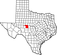 | |
| CDPs | ||
| Other unincorporated communities | ||
| Ghost town | ||