Washford River
| Washford River | |
| River | |
 The Washford River | |
| Country | England |
|---|---|
| County | Somerset |
| City | Washford |
| Source | |
| - location | Luxborough, Somerset, England |
| - elevation | 600 ft (183 m) |
| - coordinates | 51°07′39″N 3°28′50″W / 51.12750°N 3.48056°W |
| Mouth | Bristol Channel |
| - location | Watchet, Somerset, England |
| - coordinates | 51°11′00″N 3°20′09″W / 51.18333°N 3.33583°WCoordinates: 51°11′00″N 3°20′09″W / 51.18333°N 3.33583°W |
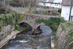
The Washford River rises at 600 feet (183 m) near Luxborough in the Brendon Hills and flows through Somerset to the Bristol Channel at Watchet.
The river valley passes through the Cleeve Hill Site of Special Scientific Interest,[1] and close to Cleeve Abbey.[2]
References
- ↑ "Cleeve Hill" (PDF). English Nature. Retrieved 2006-09-09.
- ↑ "Cleeve Abbey". National heritage list for England. English Heritage. Retrieved 11 May 2013.
| Wikimedia Commons has media related to Washford River. |
This article is issued from Wikipedia - version of the 6/16/2016. The text is available under the Creative Commons Attribution/Share Alike but additional terms may apply for the media files.