West Lyn River
| West Lyn River | |
| River | |
 Glen Lyn Gorge | |
| Country | England |
|---|---|
| County | Somerset |
| Source | |
| - location | Benjamy, The Chains, Somerset, England |
| - elevation | 400 m (1,312 ft) |
| - coordinates | 51°10′36″N 3°38′40″W / 51.17667°N 3.64444°W |
| Secondary source | Barbrook |
| - location | near Ilkerton Ridge, Devon, England |
| - elevation | 300 m (984 ft) |
| - coordinates | 51°11′20″N 3°50′30″W / 51.18889°N 3.84167°W |
| Mouth | Lynmouth |
| - elevation | 0 m (0 ft) |
| - coordinates | 51°13′46″N 3°49′44″W / 51.22944°N 3.82889°WCoordinates: 51°13′46″N 3°49′44″W / 51.22944°N 3.82889°W |
The West Lyn is a river in England which rises high in Exmoor, Somerset, and joins the East Lyn at Lynmouth in Devon.
The upper reaches have been designated as a Site of Special Scientific Interest, because of the geomorphological landforms created in the 1952 flood.[1]
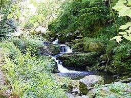
The lower reaches of the river towards Lynmouth, known as the Glen Lyn Gorge, is a tourist attraction including a museum about the local water cycle, the floods of 1952, and a small hydroelectric plant.
Water is piped from the river to generate hydroelectric power for the Lynton and Lynmouth Cliff Railway, which is a water-balance funicular railway.
References
- ↑ "River Lyn SSSI citation sheet" (PDF). English Nature. Retrieved 2009-05-26.
This article is issued from Wikipedia - version of the 6/16/2016. The text is available under the Creative Commons Attribution/Share Alike but additional terms may apply for the media files.