Waterflow, New Mexico
Waterflow is an unincorporated community in San Juan County, New Mexico, United States on the north side of the San Juan River. It is immediately west of Fruitland and north across the river from the Navajo Indian Reservation. It is east of Shiprock.[1]
Geography
Waterflow is located at 36°45′40″N 108°29′37″W / 36.76117°N 108.49357°W.[2]
Waterflow is a high desert valley with the highest point being a geological hogback called "Hogback". The San Juan River and Shumway Arroyo are important water resources in the area.
History
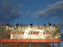
The area now known as Waterflow is traditional Navajo territory. This place was called Chʼį́įdii Łichííʼ (Red Devil) in reference to Walter Stallings who operated a trading post in the area;[3] nowadays, Tséyaa Akʼahí (beneath-rock oil) seems to be another designation in reference to the nearby oil fields, as can be seen on billboards in the area (pictured).
The early Anglo settlers in this area named the place "Jewett Valley", and established Jewett Valley Cemetery as early as 1886. Although some reports say these pioneers were predominantly Catholic, one of the earliest families to be buried in this cemetery, the Hunts, have long been LDS.[4]
Catholicism in Waterflow, New Mexico dates from February 22, 1912, when the first Mass was celebrated there in makeshift quarters. Three young men, Joseph and Lorenzo Stallings of Kentucky and David Watson of Georgia, Catholics, were among the pioneer settlers of the region. They called on the Franciscan Fathers at Farmington for help in establishing a church at Waterflow, which they called “Kentucky Mesa.” Sacred Heart Church was dedicated May 16, 1917.
The town was named "Jewett" in P. F. Collier's atlas as early as 1923. The local Catholic church remained a mission of Farmington but began to have a resident pastor in 1945. Since 1982, the Latter-day Saints have serviced their people in this area through the Kirtland Stake which covers from Kirtland west to Shiprock, New Mexico and beyond.[5]
Demographics
In 2000, Waterflow reported a total population of 1,606 people. 798 were male, and 808 were female. 295 identified themselves as White, 1 identified themselves as Black, 1 identified themselves as Asian, 59 were Hispanic, and 1,251 were Navajo. 620 speak a language other than English at home.[6] With 551 housing units and a land area of 219.58 sq. miles, there are approximately 7.31 people per sq. mile in Waterflow.[7]
Industry

Waterflow lies between two coal-fired power plants and southwest of a large coal mine.[8][9] The area also has many oil wells.[10]
While convenient for employment, this proximity has caused several large environmental issues.[11][12][13] Because of this, air quality in Waterflow is 1 on a scale to 100 (higher is better). This is based on ozone alert days and number of pollutants in the air.[14] Groundwater near the San Juan coal mine in Waterflow is extremely polluted according to both the Sierra Club and New Mexico Mining and Minerals Division.[15]
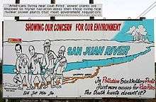
The Sierra Club alleges that the San Juan Coal Company has improperly dumped more than 40 million tons of coal ash and sludge into unlined pits, resulting in the contamination of waterways and wells near the mine.
The group says that the waste, and the contaminated water, pose a danger to livestock, wildlife and families in the area, and in early December, the Sierra Club announced that it intends to sue the owners of the San Juan Coal Company.
The company denies responsibility for the contamination.[16]
Important area businesses
- BHP Billiton
- Bob French Navajo Rugs
- Circle W Pawn
- High Country Transportation CO
- Hogback Shopping Center
- Hogback Trading Co
- Original Sweetmeat Inc., founded 1974[17]
- PNM San Juan Generating Station
- San Juan Coal CO Inc
- Thriftway Marketing Corporation NO 270
- United States Post Office, zip code 87421[18]
- Valley Hair Care
- Valley Trading Post
- Wheeler Farms
- Four Corners Generating Station
Education
Central Consolidated Schools serves Waterflow as well as other communities in western San Juan County.
Notable people from Waterflow
- Sam Howell (NASA)
- Raymond G. Hunt (controversial local hero)
- Raymond G. Hunt II (leading local businessman, patron of the arts, environmental warrior)[11][19]
- Raymond G. Hunt III (prominent local businessman)
- Raymond G. Hunt IV (heir apparent)
- Geoffrey Newman (local advocate)[20]
- Miles Wheeler (land owner, farmer)
- Valerie Wheeler (land owner)
- Jared Wright (local activist)[21]
Notes
- ↑ compare maps at and to see the location of Waterflow.
- ↑ googlemaps
- ↑ Linford, Laurance D. Navajo places: history, legend, landscape. University of Utah Press. Salt Lake City, UT: 2000. p278.
- ↑
- ↑ Kirtland New Mexico Stake homepage
- ↑ "87421 - Fact Sheet - American FactFinder". Factfinder.census.gov. Retrieved 2011-08-17.
- ↑ "87421 (Waterflow, NM 87421) Profile: Maps, Real Estate, Jobs, Schools". Newmexico.hometownlocator.com. Retrieved 2011-08-17.
- ↑ "Electricity Utility Power Company in Albuquerque, Santa Fe, New Mexico; Public Service Company of New Mexico". PNM. Retrieved 2011-08-17.
- ↑ "Electricity, Power, Energy Services for Arizona Homes and Businesses". APS. Retrieved 2011-08-17.
- ↑ https://web.archive.org/web/20100504180746/http://www.sjcounty.net/History.aspx. Archived from the original on May 4, 2010. Retrieved May 11, 2010. Missing or empty
|title=(help) - 1 2 (PDF) https://web.archive.org/web/20100412092821/http://energycommerce.house.gov/Press_111/20091210/hunt_testimony.pdf. Archived from the original (PDF) on April 12, 2010. Retrieved May 11, 2010. Missing or empty
|title=(help) - ↑ Thompson, Jonathan (2007-11-26). "Coal's other mess — High Country News". Hcn.org. Retrieved 2011-08-17.
- ↑ Sturgis, Sue. "ISS - America's hidden coal ash threat". Southernstudies.org. Retrieved 2011-08-17.
- ↑ "Best Places to Live in the United States". Bestplaces.net. Retrieved 2011-08-17.
- ↑ "Coal Combustion Waste in NM". Coalcombustionwaste-nm.org. 2008-12-27. Retrieved 2011-08-17.
- ↑ "Environmental group plans to sue over coal ash at San Juan mine". New Mexico Independent. 2008-12-27. Retrieved 2011-08-17.
- ↑ Original Sweetmeat Inc. "Original Sweetmeat Inc (The Original Sweetmeat Inc) - Waterflow, New Mexico (NM) | Company Profile". Manta.com. Retrieved 2011-08-17.
- ↑ "Google Image Result for http://farm3.static.flickr.com/2629/4012775753_acf8365481.jpg". Google.com. Retrieved 2011-08-17. External link in
|title=(help) - ↑ "Independent - June 20, 2007: Federal regs make traditional foods scarce". Gallupindependent.com. 2007-06-20. Retrieved 2011-08-17.
- ↑ Terry Pratchett (2009-08-03). "I'll die before the endgame, says Terry Pratchett in call for law to allow assisted suicides in UK | Mail Online". Dailymail.co.uk. Retrieved 2011-08-17.
- ↑ "Gay & Lesbian Mormons". Affirmation. Retrieved 2011-08-17.
Municipalities and communities of San Juan County, New Mexico, United States | ||
|---|---|---|
| Cities | 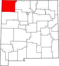 | |
| CDPs |
| |
| Other community | ||
| Indian reservation |
| |
| Footnotes | ‡This populated place also has portions in an adjacent county or counties | |
Coordinates: 36°44′21″N 108°23′44″W / 36.73917°N 108.39556°W