Atsbi Wenberta
Atsbi Wemberta (Ge'ez: ኣጽቢ ወምበርታ)(or Atsbi Ge'ez: ኣጽቢ) is one of the woredas in the Tigray Region of Ethiopia. Located in the Misraqawi Zone at the eastern edge of the Ethiopian highlands, Atsbi Wenberta is bordered on the south by the Debub Misraqawi (Southeastern) Zone, on the west by Kilte Awulaelo, on the north by Saesi Tsaedaemba, and on the east by the Afar Region. The administrative center of this woreda is Atsbi (officially Atsbi Endaselassie Ge'ez: ኣጽቢ እንዳስላሴ); other towns in Atsbi Wenberta include Haik Mesahil, Atsebi Dera, Kelisha Emni and Habes. The woreda is administratively divided into 18 Tabiyas (Kebelles).
Overview
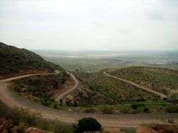
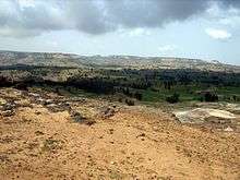
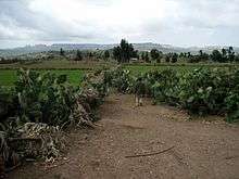
The elevation of this woreda varies from 918 to 3069 meters above sea level.[1] Rivers in Atsi Wenberta are seasonal and flow only during the rainy season. There is no lake but there are small streams and ponds. The soil is seriously degraded, and there is no forest or woodland except in a few areas along the escarpment facing the Afar Region where scattered forest is visible. Irrigation is used in the few places where it is possible; the suitable sites are rare. On many slopes the soil is so highly eroded that even when rain falls, it can retain only a small amount of moisture.[2] Nine of the 16 peasant associations in Atsbi Wenberta have an elevation of 2600 meters or higher, and are planted in barley, wheat, pulses like faba beans, and small ruminants like sheep are raised. The other seven peasant associations have an elevation below 2600 meters and are planted in teff, wheat, and barley, and both livestock and apiculture are cultivated; 6729 bee colonies are reported in this woreda. A major cash crop are faba beans, and Atsi Wenbarta is an important supplier of sheep and goats for meat to the nearby towns of Wukro, Adigrat, and the city of Mekelle.[1]
There are several local monolithic churches in this woreda, which include Mikael Barka, and Mikael Imba.[3] There are also several churches which were originally built in Aksumite times; these include Mikael Debre Selam and Zarema Giyorgis located northwest of Atsbi.[4] One micro-finance institution operates in Atsbi Wenberta, the Dedebit Credit and Saving Institution SC, with two sub-branches in Atsbi which report to the office in Wukro. There are 16 multipurpose cooperatives in this woreda, one for each kebele. However, these cooperatives have faced a number of problems, which include a failure to compete successfully with local private traders and the discovery after a 2004 audit of all of the cooperatives that 47,000 Birr was missing.[1]
History
Historically, the district of Wemberta has been an integral part of Enderta province, when Enderta was an independent province as well as an awraja as recent as the late 1990s [5][6]
Wemberta was occupied by the Ethiopian People's Revolutionary Party (EPRP) in 1978. Local shifta (or brigands) are said to have joined the EPRP and robbed woreda inhabitants, using the political organization as a cover. They killed at least one man known as Hagos Tesfu. However, when the EPRP left, the shifta remained in the area. The Derg then organized the local people against these shifta, which resulted with one killed, one fleeing to the Afar Depression, and four being executed. In 1980, the Tigrayan People's Liberation Front took control of the area, which resulted in numerous military campaigns by the Derg; woreda inhabitants were arrested or killed by the military, their livestock were killed and married women raped.[2]
Atsbi Wenberta was one of nine woredas in Tigray most affected by a drought during 2008, requiring emergency food supplies requested for an estimated 600,000 people.[7]
Hura Seleste (ሁራ ሰለስተ)
Any body who flew to Atsbi Wenberta, he/she definitely get astonished by the number of dancing styles available on the wereda like Hura-Seleste (ሁራ ሰለስተ), Gumaye (ጉማዬ), Tegomtsets (ተጎምጸጽ), Tilhit (ትልሂት), etc. Among all here is the most exciting one and gained popularity in the neighboring woredas of Tigray and Afar regions, is Hura Seleste.
Hura-Seleste evolves from the history of the relation between Atsbians and Axumite kingdom, in which “Royal Axumite Troops” have had guarded their national fervour. It is a type of dancing with an intricate foot work in which the entitled youngsters or men can play on a circular pattern after single Hura song.
The culture and culinary of the woreda is heavily influenced by Enderta, Agame and Raya of the Tigrayans, and the Afars whereby it's the interface of the four local cultures. Tihilo (ጥሕሎ), Gogo (ጎጎ), Kitcha bMear (ቅጫ ብመዓር), Siwa (ስዋ), and Mies (ሜስ) (Tejj Honey-wine) are the popular foods and drinks.
Demographics
Based on the 2007 national census conducted by the Central Statistical Agency of Ethiopia (CSA), this woreda has a total population of 112,341, an increase of 85,561 over the 1994 census, of whom 53,659 are men and 58,682 women; 11,144 or 9.92% are urban inhabitants. With an area of 1,758.11 square kilometers, Atsbi Wonberta has a population density of 63.90, which is greater than the Zone average of 56.93 persons per square kilometer. A total of 26,425 households were counted in this woreda, resulting in an average of 4.25 persons to a household, and 25,533 housing units. The majority of the inhabitants said they practiced Ethiopian Orthodox Christianity, with 97.79% reporting that as their religion, while 2.12% of the population were Muslim.[8]
The 1994 national census reported a total population for this woreda of 93,659 of whom 45,521 were men and 48,138 were women; 32,229 or 34.41% of its population were urban dwellers. The three largest ethnic groups reported in Atsbi Wenberta were the Tigrayan (62.19%), the Amhara (33.91%), and the Oromo (2.24%); all other ethnic groups made up 1.66% of the population. Tigrinya is spoken as a first language by 61.36%, 36.48% Amharic, and 1.36% speak Oromiffa; the remaining 0.8% spoke all other primary languages reported. 78.35% of the population said they were Ethiopian Christians, and 21.45% were Muslim. Concerning education, 14.76% of the population were considered literate, which is greater than the Zone average of 9.01%; 20.65% of children aged 7-12 were in primary school, which is more than the Zone average of 11.34%; 3.09% of the children aged 13-14 were in junior secondary school, which is more than the Zone average of 0.65%; 3.38 of the inhabitants aged 15-18 were in senior secondary school. Concerning sanitary conditions, 91% of the urban houses and 43% of all houses had access to safe drinking water at the time of the census; about 12% of the urban and 31% of the total had toilet facilities.[9]
Agriculture
A sample enumeration performed by the CSA in 2001 interviewed 21,729 farmers in this woreda, who held an average of 0.46 hectares of land. Of the 10,040 hectares of private land surveyed, 84.53% was under cultivation, 4.15% pasture, 3.95% fallow, 1.24% in woodland, and 6.11% was devoted to other uses. For the land under cultivation in this woreda, 69% was planted in cereals, 12.9% in pulses, 0.64% in oilseeds, and 2 hectares in vegetables. The total area planted in fruit trees was 186 hectares, while 1 hectare was planted in gesho. 74.65% of the farmers both raised crops and livestock, while 19.36% only grew crops and 5.99% only raised livestock. Land tenure in this woreda is distributed amongst 93.18% owning their land, 5.56% renting, and 1.28% holding their land under other forms of tenure.[10]

Surrounding woredas
 |
Saesi Tsaedaemba | Saesi Tsaedaemba | Afar Region | |
| Kilte Awulaelo | |
Afar Region | ||
| ||||
| | ||||
| Debub Misraqawi Zone | Debub Misraqawi Zone | Afar Region |
Notes
- 1 2 3 "Pilot Learning Weredas: Atsi Wenberta" Archived December 8, 2008, at the Wayback Machine. (October 2004), IPMS Information Resources Portal - Ethiopia, pp. 5-16. (accessed 3 March 2009)
- 1 2 "Ethiopian Village Studies: Harresaw, Atsbi Woreda, Tigray", p. 1 Centre for the Study of African Economies website (accessed 10 September 2009)
- ↑ Described in Philip Briggs, Ethiopia: The Bradt Travel Guide, 3rd edition (Chalfont St Peters: Bradt, 2002), p. 260-262.
- ↑ Described in David W. Phillipson, Ancient Churches of Ethiopia (New Haven: Yale University Press, 2009), pp. 68-71, 73f
- ↑ Ethiopian Mapping Authority, 1997
- ↑ Sarah Vaughan, "Ethnicity and Power in Ethiopia", PhD dissertation, p. 123, 2003
- ↑ "Kahsay Beyen: 'This is the worst drought I have seen in my life'" Archived June 12, 2011, at the Wayback Machine., "Ethiopia: Drought intensifies in Tigray" IRIN (last accessed 8 December 2008
- ↑ Census 2007 Tables: Tigray Region Archived November 14, 2010, at the Wayback Machine., Tables 2.1, 2.4, 2.5 and 3.4.
- ↑ 1994 Population and Housing Census of Ethiopia: Results for Southern Nations, Nationalities and Peoples' Region, Vol. 1, part 1 Archived November 19, 2008, at the Wayback Machine., Tables 2.1, 2.12, 2.19, 3.5, 3.7, 6.3, 6.11, 6.13 (accessed 30 December 2008)
- ↑ "Central Statistical Authority of Ethiopia. Agricultural Sample Survey (AgSE2001). Report on Area and Production - Tigray Region. Version 1.1 - December 2007" Archived November 14, 2009, at the Wayback Machine. (accessed 26 January 2009)
Coordinates: 13°40′N 39°45′E / 13.667°N 39.750°E
Woredas of the Misraqawi Zone | ||
|---|---|---|
 | ||