West Antarctica
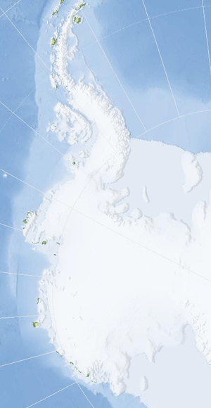

West Antarctica, or Lesser Antarctica, one of the two major regions of Antarctica, is the part of that continent that lies within the Western Hemisphere, and includes the Antarctic Peninsula. It is separated from East Antarctica by the Transantarctic Mountains and is covered by the West Antarctic Ice Sheet. It lies between the Ross Sea (partly covered by the Ross Ice Shelf), and the Weddell Sea (largely covered by the Filchner-Ronne Ice Shelf). It may be considered a giant peninsula stretching from the South Pole towards the tip of South America.
West Antarctica is largely covered by the Antarctic ice sheet, but there have been signs that climate change is having some effect and that this ice sheet may have started to shrink slightly. The coasts of the Antarctic Peninsula are the only parts of West Antarctica that become (in summer) ice-free. These constitute the Marielandia Antarctic tundra and have the warmest climate in Antarctica. The rocks are clad in mosses and lichens that can cope with the intense cold of winter and the short growing-season.
Location and description
Lying on the Pacific Ocean side of the Transantarctic Mountains, West Antarctica comprises the Antarctic Peninsula (with Graham Land and Palmer Land) and Ellsworth Land, Marie Byrd Land and King Edward VII Land, offshore islands such as Adelaide Island, and ice shelves, notably the Filchner-Ronne Ice Shelf on the Weddell Sea, and the Ross Ice Shelf on the Ross Sea. The Ross Sea and the Weddell Sea separate West Antarctica from the main land-mass of the continent: one can think of West Antarctica as a giant peninsula that stretches roughly from the South Pole towards the southern tip of South America.
West Antarctica was named in the early 20th century (Balch, 1902; Nordenskiöld, 1905); that usage became standard following the International Geophysical Year (1957–1958) and explorations which disclosed that the Transantarctic Mountains provide a useful regional border between West Antarctica and East Antarctica. Advisory Committee on Antarctic Names (US-ACAN) approved the name in 1962.
West Antarctica is mostly covered by a massive ice sheet referred to as the West Antarctic Ice Sheet (WAIS). In recent decades this ice sheet has shown signs of decreasing mass.[1]
Unlike East Antarctica, West Antarctica has shown some effects of global warming.[2]
Marielandia Antarctic tundra
The parts of West Antarctica not covered with ice (Antarctic oasis), which are the coasts of the Antarctic Peninsula, constitute a biodiversity region known as Marielandia Antarctic tundra (after Marie Byrd Land).[3] This area has the warmest climate in Antarctica and the moss and lichen-covered rocks are free of snow during the summer months, although the weather is still intensely cold and the growing season very short.
See also
References
![]() This article incorporates public domain material from the United States Geological Survey document "West Antarctica" (content from the Geographic Names Information System).
This article incorporates public domain material from the United States Geological Survey document "West Antarctica" (content from the Geographic Names Information System).
- ↑ "Antarctic ice sheet is an 'awakened giant'". New Scientist. 2 February 2005. Retrieved 2008-01-26.
- ↑ Vergano, Dan (2012-12-23). "Western Antarctica warming confirmed". USA Today. Retrieved 2016-02-19.
Temperatures in West Antarctica have increased at a rate nearly twice[ ]as large as the global average, a 4.3 degree Fahrenheit increase since 1958, conclude meteorologists in the journal, Nature Geoscience, out Sunday.[ ]The finding adds Western Antarctica to the list of hot spots most affected by global warming [...].
- ↑ World Wildlife Fund (2001). "Marielandia Antarctic tundra". WildWorld Ecoregion Profile. National Geographic Society. Archived from the original on 2010-03-08. Retrieved 2008-01-26.
| General | .svg.png) | |
|---|---|---|
| Geographic regions | ||
| Waterways | ||
| Famous explorers | ||
Coordinates: 79°S 100°W / 79°S 100°W