West Greenwich, Rhode Island
| West Greenwich, Rhode Island | |
|---|---|
| Town | |
|
Louttit Library | |
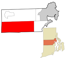 Location in Kent County and the state of Rhode Island. | |
| Coordinates: 41°37′46″N 71°39′37″W / 41.62944°N 71.66028°WCoordinates: 41°37′46″N 71°39′37″W / 41.62944°N 71.66028°W | |
| Country | United States |
| State | Rhode Island |
| County | Kent |
| Government | |
| • Type | 5 member Town council |
| • Town Council |
Mark D. Tourgee (R) Robert J. Andrews (R) Susan G. Woloohojian (R) Linda R. Sloan (R) Thomas E. Mulcahey (R) |
| Area | |
| • Total | 51.3 sq mi (132.9 km2) |
| • Land | 50.6 sq mi (131.1 km2) |
| • Water | 0.7 sq mi (1.8 km2) |
| Elevation | 253 ft (77 m) |
| Population (2010) | |
| • Total | 6,135 |
| • Density | 121.2/sq mi (46.8/km2) |
| Time zone | Eastern (EST) (UTC-5) |
| • Summer (DST) | EDT (UTC-4) |
| ZIP code | 02817 |
| Area code(s) | 401 |
| FIPS code | 44-77720[1] |
| GNIS feature ID | 1220059[2] |

West Greenwich is a town in Kent County, Rhode Island, United States. The population was 6,135 at the 2010 census. West Greenwich was named for the historic town of Greenwich, Kent, England. It was separated from East Greenwich in 1741. Students are go to Exeter-West Greenwich Regional School in West Greenwich.
Geography
According to the United States Census Bureau, the town has a total area of 51.3 square miles (133 km2), of which, 50.6 square miles (131 km2) of it is land and 0.7 square miles (1.8 km2) of it (1.34%) is water. Escoheag Hill is located within the town and is the site of a former ski area.
Demographics
| Historical population | |||
|---|---|---|---|
| Census | Pop. | %± | |
| 1790 | 2,054 | — | |
| 1800 | 1,757 | −14.5% | |
| 1810 | 1,619 | −7.9% | |
| 1820 | 1,927 | 19.0% | |
| 1830 | 1,817 | −5.7% | |
| 1840 | 1,415 | −22.1% | |
| 1850 | 1,350 | −4.6% | |
| 1860 | 1,258 | −6.8% | |
| 1870 | 1,133 | −9.9% | |
| 1880 | 1,018 | −10.2% | |
| 1890 | 798 | −21.6% | |
| 1900 | 606 | −24.1% | |
| 1910 | 481 | −20.6% | |
| 1920 | 367 | −23.7% | |
| 1930 | 402 | 9.5% | |
| 1940 | 526 | 30.8% | |
| 1950 | 847 | 61.0% | |
| 1960 | 1,169 | 38.0% | |
| 1970 | 1,841 | 57.5% | |
| 1980 | 2,738 | 48.7% | |
| 1990 | 3,492 | 27.5% | |
| 2000 | 5,085 | 45.6% | |
| 2010 | 6,135 | 20.6% | |
| Est. 2015 | 6,134 | [3] | 0.0% |
As of the census[1] of 2000, there were 5,085 people, 1,749 households, and 1,451 families residing in the town. The population density was 100.4 people per square mile (38.8/km²). There were 1,809 housing units at an average density of 35.7 per square mile (13.8/km²). The racial makeup of the town was 97.70% White, 0.28% African American, 0.24% Native American, 0.57% Asian, 0.24% from other races, and 0.98% from two or more races. Hispanic or Latino of any race were 0.69% of the population.
There were 1,749 households out of which 42.7% had children under the age of 18 living with them, 72.3% were married couples living together, 7.4% had a female householder with no husband present, and 17.0% were non-families. 13.0% of all households were made up of individuals and 3.6% had someone living alone who was 65 years of age or older. The average household size was 2.90 and the average family size was 3.18.
In the town the population was spread out with 28.4% under the age of 18, 6.1% from 18 to 24, 33.4% from 25 to 44, 25.1% from 45 to 64, and 7.1% who were 65 years of age or older. The median age was 37 years. For every 100 females there were 100.4 males. For every 100 females age 18 and over, there were 99.5 males.
The median income for a household in the town is $65,725, and the median income for a family is $71,332. Males have a median income of $44,306 versus $32,933 for females. The per capita income for the town is $25,750. 4.2% of the population and 2.5% of families are below the poverty line. Out of the total population, 2.7% of those under the age of 18 and 15.9% of those 65 and older are living below the poverty line.
Historic Places
- Louttit Library (1936)
- West Greenwich Baptist Church and Cemetery (1822)
- Stephen Allen House (1787)
- Hopkins Hollow Village (1728)
References
- 1 2 "American FactFinder". United States Census Bureau. Retrieved 2008-01-31.
- ↑ "US Board on Geographic Names". United States Geological Survey. 2007-10-25. Retrieved 2008-01-31.
- ↑ "Annual Estimates of the Resident Population for Incorporated Places: April 1, 2010 to July 1, 2015". Retrieved July 2, 2016.
- ↑ "Census of Population and Housing". Census.gov. Retrieved June 4, 2016.
- ↑ Snow, Edwin M. (1867). Report upon the Census of Rhode Island 1865. Providence, RI: Providence Press Company.
External links
| Wikivoyage has a travel guide for West Greenwich. |
Municipalities and communities of Kent County, Rhode Island, United States | ||
|---|---|---|
| City |  | |
| Towns | ||
| Villages | ||
Providence (capital) | |
| Topics |
|
| Society |
|
| Regions | |
| Cities | |
| Towns |
|