White Post Township, Pulaski County, Indiana
| White Post Township | |
|---|---|
| Township | |
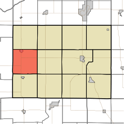 Location in Pulaski County | |
| Coordinates: 41°02′21″N 86°52′23″W / 41.03917°N 86.87306°WCoordinates: 41°02′21″N 86°52′23″W / 41.03917°N 86.87306°W | |
| Country |
|
| State |
|
| County | Pulaski |
| Government | |
| • Type | Indiana township |
| Area | |
| • Total | 36.46 sq mi (94.4 km2) |
| • Land | 36.46 sq mi (94.4 km2) |
| • Water | 0 sq mi (0 km2) 0% |
| Elevation | 676 ft (206 m) |
| Population (2010) | |
| • Total | 1,075 |
| • Density | 29.5/sq mi (11.4/km2) |
| ZIP codes | 47946, 47957 |
| GNIS feature ID | 0454052 |
White Post Township is one of twelve townships in Pulaski County, Indiana, United States. As of the 2010 census, its population was 1,075 and it contained 474 housing units.[1] The township is a almost precise 6 mile by 6 mile square; 36.46 square miles and runs from the intersection of County Road 200N and County Road CR1700W (Jasper County line) southwards along CR1700W to CR400S thence east to CR 1100W thence north to CR200N and finally back west to the origin.
White Post Township took its name from a stagecoach stop named White Post, and it is supposed the stop was named for a nearby large white stump.[2]
Geography
According to the 2010 census, the township has a total area of 36.46 square miles (94.4 km2), all land.[1]
Cities, towns, villages
Adjacent townships
- Cass Township (north)
- Rich Grove Township (northeast)
- Jefferson Township (east)
- Beaver Township (southeast)
- Salem Township (south)
- Gillam Township, Jasper County (west)
Cemeteries
The township contains five cemeteries: Whtie Post, Medaryville (or Rose Hill), Bowman, Saint Henry's and Saint Mark's.
Major highways
School districts
- West Central School Corporation
Political districts
- Indiana's 2nd congressional district
- State House District 20
- State Senate District 18
References
- United States Census Bureau 2008 TIGER/Line Shapefiles
- United States Board on Geographic Names (GNIS)
- IndianaMap
- 1 2 "Population, Housing Units, Area, and Density: 2010 - County -- County Subdivision and Place -- 2010 Census Summary File 1". United States Census. Retrieved 2013-05-10.
- ↑ Counties of White and Pulaski, Indiana: Historical and Biographical. F.A. Battey & Company. 1883. p. 572.
External links
 |
Cass Township | Rich Grove Township | | |
| Gillam Township, Jasper County | |
Jefferson Township | ||
| ||||
| | ||||
| Salem Township | Beaver Township |
Municipalities and communities of Pulaski County, Indiana, United States | ||
|---|---|---|
| Towns | ||
| Townships | ||
| CDP | ||
| Other unincorporated communities |
| |