Wilcrick
| Wilcrick | |
| Welsh: Chwilgrug | |
 Wilcrick Hill |
|
| Population | 24 (1961 census) |
|---|---|
| OS grid reference | ST409879 |
| Principal area | Newport |
| Ceremonial county | Gwent |
| Country | Wales |
| Sovereign state | United Kingdom |
| Post town | CALDICOT |
| Postcode district | NP26 |
| Dialling code | 01633 |
| Police | Gwent |
| Fire | South Wales |
| Ambulance | Welsh |
| EU Parliament | Wales |
| UK Parliament | Newport East |
Wilcrick (Welsh: Chwilgrug) is a small village within the administrative boundary of the city of Newport, South Wales, just to the west of Magor. It is within the historic county of Monmouthshire.
Etymology
The name translates from the Welsh as a "bare hill" or "mound".[1]
Archaeology
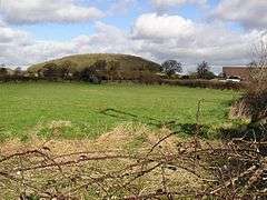
Willcrick is located on the B4245 road to the northwest of Magor. To the southeast of the village is Wilcrick Hill which has a hillfort on its summit,[2] of which only the earthworks remain. Archaeological evidence, in the form of a small Iron Age settlement found preserved under peat at Barland's Farm, suggests that the occupiers probably moved inland, from the lower lying and wetter Caldicot Level, with their grazing cattle, when water-levels rose in the autumn, possibly to the hillfort which overlooks the site.[3]
Nearby, a nearly complete 3rd century Romano-British oak boat was found beside a buried stone and timber quay in 1993, during the building of a distribution depot at the nearby Europark. This suggests that much higher water levels prevailed on the Levels at the time.[4][5]
The church
The parish church is dedicated to St. Mary, with the minister historically being also the minister for Llanmartin. The only ministers not appearing also as ministers there were Peter Ameline, rector of Wilcrick in 1535 and Edmond Jones instituted to Wilcrick on 16 July 1631. After that the names and dates of ministers for both parishes are the same. The church has a bell of 1726 cast by the Evans foundry of Chepstow.[6]
Historian J.A. Bradney describes the church as comprising nave and chancel, with a bell turret at the west end and containing "nothing of interest except an ancient font". The whole edifice was rebuilt in 1860.[7]
References
- ↑ Owen, Hywel Wyn; Morgan, Richard (2007). Dictionary of the Place-Names of Wales. Gomer. p. 101. ISBN 978-1-84323-901-7.
- ↑ Concise Road Atlas: Britain. AA Publishing. 2015. p. 28. ISBN 978-0-7495-7743-8.
- ↑ Martin, Caroline (2001). "Willcrick - Bishton". Hillforts of Gwent: In Search of the Iron Age. Retrieved 2 May 2016.
- ↑ "Historic Landscape Characterisation the Gwent Levels". The Glamorgan-Gwent Archaeological Trust. Retrieved 2 May 2016.
- ↑ Newton-Davies, Victoria (2004). "Barland's Farm boat" (PDF). The Newport Ship site. Retrieved 2 May 2016.
- ↑ "Rectorial Benefice of Magor St Martin's Church, Llanmartin". The Magor Benefice website. Archived from the original on 15 February 2015. Retrieved 2 May 2016.
- ↑ Bradney, J. A., A History of Monmouthshire from the Coming of the Normans Into Wales Down to the Present Time, Volume 4, Parts 1 and 2 - The Hundred of Caldicot, published 1929 and 1932
External links
Coordinates: 51°35′13″N 2°51′16″W / 51.58684°N 2.85443°W