Witwatersrand Basin
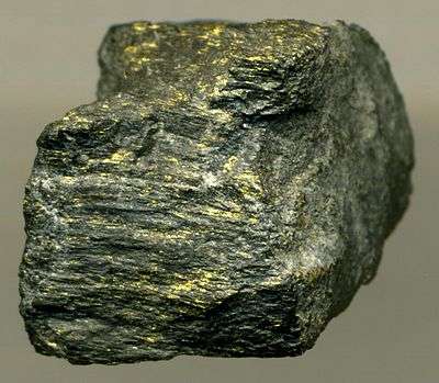
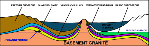
The Witwatersrand Basin is a largely underground geological formation which surfaces in the Witwatersrand, South Africa. It holds the world's largest known gold reserves and has produced over 1.5 billion ounces (over 40,000 metric tons), which represents about 50% of all the gold ever mined on earth.[1] The basin straddles the old provinces of Transvaal and the Orange Free State, and consists of a 5000–7000 m thick layer of Archean, mainly sedimentary rocks laid down over a period of about 260 million years, starting about 3000 million years ago.[2] The entire series of rocks, known as the “Witwatersrand Supergroup’’ consists of quartzites, banded ironstones, mudstones, tillites, conglomerates and some marine lava deposits. Most of the basin is deeply buried under younger rocks, but outcrops occur in Gauteng, the Free State, as well as in some of the surrounding Provinces. The outcrop in Gauteng forms the Witwatersrand ridge, from which the basin and its rocks derive their name. It was on the southern portion of this ridge that gold was first discovered on the farm Langlaagte in 1886, 5 km west of Johannesburg.[1][3] Since this gold was embedded in a conglomerate, it was first assumed that this was alluvial gold in an old riverbed, that had been tilted as a result of earth movements.[1][3] However, when it was found that, traced downdip, the conglomerate was not merely developed for the narrow width of a river, but continued in depth, there came the realization that this conglomeratic zone was part of a sedimentary succession.[3] The conglomerate was quickly traced east and westward for a total continuous distance of 50 km to define what became known as the “Central Rand Gold Field”.
It has since been established that the rocks that make up the Witwatersrand Ridge dip downwards and southwards to form the largely underground “Witwatersrand Basin” which covers an elliptical area with a 300 km long major axis from Evander in the north-east to Theunissen in the south-west, and 150 km wide stretching from Steynsrus in the south-east to Coligny in the north-west,[3] with a small subsidiary basin at Kinross. Gold occurs only along the northern and western margins of this basin, but not in a continuous band. The gold bearing rocks are limited to 6 sites where Archean rivers from the north and west formed fan deltas, with many braided channels, before flowing into the “Witwatersrand Sea” to the south, where the earlier sediments that form the older rocks of the Witwatersrand Supergroup had been deposited. Some of these gold bearing fan deltas are now at depths of 4 km below the surface.[1][3] Although many of the older mines, around Johannesburg, are now nearly exhausted, the Witwatersrand Basin still produces most of South Africa's gold and much of the total world output. Silver, uranium, and iridium are recovered as gold-refining by-products.[4]
Geological origin
The Witwatersrand basin was created during the Archean Eon, and is therefore amongst the oldest geological structures on earth. It was laid down in two stages, over the course of 260 million years starting just short of 3000 million ago. The first phase, lasting 60 million years, consisted of sedimentary deposits in a shallow sea, conveniently named the “Witwatersrand Sea”. The resulting 2500–4500 m thick layer of sediments is termed the “West Rand Group” of Witwatersrand rocks. The second phase, which lasted for 200 million years, followed on from the first phase, with on-land deposits, resulting from the retreat of the Witwatersrand Sea, leaving a wide almost flat coastal plain over which rivers from the north formed wide braided river deltas, into some of which rich deposits of gold were deposited. The resulting 2500 m thick layer of rock is termed the “Central Rand Group”. The “West Rand Group” and “Central Rand Group” of rocks together form the “Witwatersrand Supergroup”, the full horizontal extent of which is termed the Witwatersrand Basin.[1][2][3]


There were no continents during the early stages of the Archean Eon,[6] but island arcs did form. It was the coalescence of several of these island arcs that led to the formation of the Kaapvaal Craton, one of the first microcontinents to form on earth about 3900 million years ago.[2] Its size and position relative to Southern Africa today are indicated in the diagram on the left. About 3000 million years ago local cooling of the underlying asthenosphere caused subsidence of the south eastern portion of this microcontinent below sea level.[2] The floor of this newly formed “Witwatersrand sea” consisted of smoothly eroded granites. Sandy sediments brought in by rivers from the north started being deposited on the granite about 2970 million years ago. This sandy layer eventually became compressed to form the Orange Grove Quartzite, the lowermost layer of the Witwatersrand Supergroup. This quartzite layer can be seen lying on its granite base in Johannesburg, where it forms a 56 km long east-west ridge over which several rivers running to the north form waterfalls, giving rise to the name Witwatersrand, which in Afrikaans means “Ridge of White Waters”.
There was no free oxygen in earth’s atmosphere till about 2000 million years ago, but there were photosynthesizing cyanobacteria.[5] The oxygen these microorganisms produced rapidly reacted with, amongst others, any dissolved iron compounds in the water, producing insoluble red iron oxide (rust), which precipitated out during the daylight hours. At night these reactions stopped. The result was alternating red and gray layers of mud which, when consolidated, became banded ironstones.[5]
As the sea deepened finer grained and muddy sediments accumulated. But changing geographical conditions resulted in the accumulation of a wide variety of sediments, ranging from mud, to sand, to gravel, and banded ironstones. Tillite deposits, dating from 2950 million years ago, are indicative of the first glaciation episodes on earth.[2][7] Within 60 million years, up to 4500 m of sediment had accumulated on the granite base, to become the “West Rand Group” of rocks that contribute over 60% of the total thickness of the Witwatersrand Supergroup.[1][2][7]
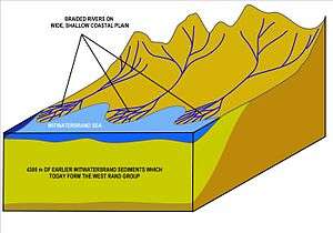
Uplifting of the north of the Kaapvaal Craton, in addition to orogenesis (mountain formation), towards the end of the deposition of the “West Rand Group” of sediments caused the Witwatersrand sea to retreat. The area of the craton on top of which Johannesburg is now situated, became a vast riverine plain, which extended along the entire northern and western shoreline of the shrunken sea, in an arc extending from Evander in the east, through Johannesburg, Carletonville and then southwards to Klerksdorp and Welkom in the south-west. The rivers formed braided deltas with many interlacing, slow flowing channels where all the heavy materials brought down from the mountains were deposited: large pebbles, and heavy minerals, such as gold, iron pyrite, and uraninite. The gold was in its free elemental form. Cyanobacteria grew in relative abundance in these mineral rich waters.[1][2][7] The kerogen, or bitumen, that is found in association with the gold deposits almost certainly represents what remains of these Archean photosynthesizing micro-organisms.[2]
It is clear that for the next 200 million years the flood plain was repeatedly inundated, sometimes eroded, and sediments re-deposited. The result was a 2500 m thick layer of rock that is termed the “Central Rand Group”, which together with the “West Rand Group”, forms the “Witwatersrand Supergroup”. It is the younger Central Rand Group that contains most of the gold bearing conglomerates that are today of great economic importance.
The “Central Rand Group” of deposits was brought to an abrupt end by massive outpourings of lava, which form the Ventersdorp lavas which erupted 2715 million years ago.[2] The cause of these lava outpourings is a matter of speculation. It might be related to the collision of the Kaapvaal craton with the Zimbabwe craton, eventually to become knitted together to form a single continental unit.
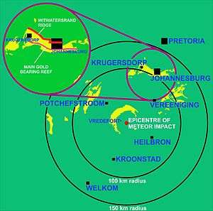
A final event that had a major impact on the geology of the Witwatersrand Basin and its exposure in the Johannesburg region, was a massive meteor impact 110 km to the south-west of Johannesburg 2020 million years ago.[1][2] The epicenter of the impact was close to the present village of Vredefort, which has given its name to the geological remnant of this immense event: the Vredefort Dome. Not only are the remains of this impact the oldest on earth, but it is also the largest meteor impact that has left its imprint on the earth’s geology of today.[1][2] A meteor 10–15 km across created a 300 km diameter crater, distorting all the rock strata within that circle. Johannesburg is just within the outer edge of this impact crater. In the immediate vicinity of the impact all the subterranean strata were uplifted and upturned, so that Witwatersrand rocks are exposed in an arc 25 km away from the impact center. There are unfortunately no gold deposits in these outcrops. The meteor impact, however, lowered the Witwatersrand basin inside the crater. This protected it from erosion later on; but, possibly more importantly, bringing it to the surface close to the crater rim, near Johannesburg.[2] In fact, apart from the Witwatersrand outcrops (i.e. where these rocks are exposed at the surface) in the immediate vicinity of the Vredefort Dome, virtually all the other outcrops occur in an arc approximately 80–120 km from the center of the impact crater, to the west, north-west, north and north-east.[8] Thus, it is possible that if it had not been for the Vredefort meteor strike 2000 million years ago, we would either have never discovered the rich gold deposits beneath the Southern African surface, or they would have been eroded away during the uninterrupted removal of a several kilometers thick layer of deposits from the surface of the Southern African Plateau in the relatively recent geological past: i.e. the past 150 million years, but especially during the last 20 million years.[2]
Gold origin
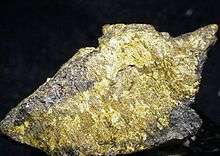
The vast majority of the Earth's gold and other heavy metals are locked up in the earth’s core. Evidence from tungsten isotope studies indicates that most gold in the crust is derived from gold in the mantle which resulted from a meteorite bombardment some 3900 million years ago (i.e. at approximately the time that the Kaapvaal craton formed). The gold bearing meteorite events occurred millions of years after the segregation of the earth's core.[9] The gold in the Witwatersrand Basin area was deposited in Archean river deltas having been washed down from surrounding gold-rich greenstone belts to the north and west. Rhenium-osmium isotope studies indicate that the gold in those mineral deposits came from unusual 3000 million year old mantle-derived intrusions known as komatiite, present in the greenstone belts.[10]
See also
References
- 1 2 3 4 5 6 7 8 9 Norman, N., Whitfield, G. (2006) ‘’Geological Journeys’’. p. 38-49, 60-61. Struik Publishers, Cape Town.
- 1 2 3 4 5 6 7 8 9 10 11 12 13 McCarthy, T., Rubridge, B. (2005). ‘’The Story of Earth and Life.’’ p. 89-90, 102-107, 134-136. Struik Publishers, Cape Town
- 1 2 3 4 5 6 7 Truswell, J.F. (1977). ‘’The Geological Evolution of South Africa’’. p. 21-24, 27-28, 33-36, . Purnell, Cape Town.
- ↑ http://www.goldsheetlinks.com/production.htm
- 1 2 3 Margulis, L., Sagan, D. (1995). ’’What is Life?’’. p. 81-83. Weidenfeld and Nicolson, London.
- ↑ Stanley, S.M. (1999). Earth System History. pp. 297-301. W.H. Freeman and Company, New York. ISBN 0-7167-2882-6.
- 1 2 3 Tankard, A.J., Jackson, M.P.A, Erikson, K.A., Hobday, D.K., Hunter, D.R., Minter, W.E.L. (1982). Crustal Evolution of Southern Africa. 3.8 Billion Years of Earth History.pp. 118-139. Springer-Verlag, New York.
- ↑ Geological map of South Africa, Lesotho and Swaziland (1970). Council for Geoscience, Geological Survey of South Africa.
- ↑ Battison, Leila; Meteorites delivered gold to Earth, BBC News, Science & Environment, 8 September 2011
- ↑ Kirk, Jason; Joakin Ruiz; John Chesley and Spencer Titley; The Origin of Gold in South Africa, American Scientist, Vol 91, Nov.-Dec 2003, pp. 534–531
External links
- Relationships between the Vredefort structure and the Witwatersrand basin within the tectonic framework of the Kaapvaal craton as interpreted from regional gravity and aeromagnetic data
- River of the Crater
Coordinates: 25°46′31″S 28°04′19″E / 25.7753°S 28.0719°E