Wolsty
| Wolsty | |
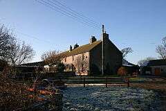 Wolsty Hall, one of the farms in the hamlet |
|
 Wolsty |
|
| OS grid reference | NY104509 |
|---|---|
| Civil parish | Holme Low |
| District | Allerdale |
| Shire county | Cumbria |
| Region | North West |
| Country | England |
| Sovereign state | United Kingdom |
| Post town | WIGTON |
| Postcode district | CA7 |
| Dialling code | 016973 |
| Police | Cumbria |
| Fire | Cumbria |
| Ambulance | North West |
| EU Parliament | North West England |
| UK Parliament | Workington |
Coordinates: 54°50′43″N 3°23′42″W / 54.8454°N 3.3949°W
Wolsty is a small hamlet in the civil parish of Holme Low in Cumbria, United Kingdom. It is located three-and-a-quarter miles south of Silloth-on-Solway, five miles west of Abbeytown, three-and-a-quarter miles north of the village of Mawbray, and twenty-three miles west of Cumbria's county town, Carlisle. The B5300 coast road, which heads north toward Silloth-on-Solway and south to Mawbray, Allonby, and Maryport, is three-quarters of a mile away by road, or less than a quarter of a mile by way of an unpaved farm track.[1]
History and etymology
The name "Wolsty" is derived from the Old English wulf-stīg, meaning a "wolf-frequented path". There have been several recorded variant spellings, including Woulstie, Worsty, Wristie, Wolmsty, and Ulsty.[2]
The area around Wolsty was fortified during the Roman period, when a series of milefortlets were constructed beyond the western end of Hadrian's Wall to guard against incursions across the Solway Firth. Milefortlets 13 and 14 are located in the vicinity of the hamlet.[3]
During the 14th century, coastal raids by Scots were still commonplace, plaguing settlements like Wolsty. To defend the vulnerable Holme Abbey at nearby Abbeytown, a castle was constructed at Wolsty to defend the coast. After falling into disrepair by the 1570s, attempts to repair the castle were undertaken in the 1630s, but with the kingdoms of England and Scotland edging closer toward friendship, the castle was no longer needed and had been demolished by the year 1700. The castle would have proven formidable to raiding parties; remaining archaeological evidence has shown that there was a moat, and that the walls were over two metres thick.[4] The castle is scheduled under the Ancient Monuments and Archaeological Areas Act 1979 as a site of "national importance".[5] An archaeological dig was carried out on the site in July 2013.[6][7]
Wolsty also appears to have taken part in the "seawake", a night watch along the coast. Residents of coastal communities took turns standing watch along the coast to guard against raids. In the 1570s, farmers at Wolsty would have had to trek to Dubmill, a little over four miles away past Hailforth and Salta, to grind their grain at the mill there.[8] The hamlet became part of the new parish of Holme Low (previously known as Holme St. Pauls or Low Holme), when it was separated from the parish of Holme Abbey in 1845.[9] This was done following the construction of St. Paul's church at nearby Causewayhead.[10]
The hamlet today
Wolsty today remains a farming settlement, but it is quite small and has no facilities or amenities of its own. The nearest shops are in Silloth-on-Solway,[11][12] three-and-a-quarter miles to the north, and there is a bus service which runs along the B5300 coast road between Silloth-on-Solway and Maryport approximately every two hours in either direction.[13] At nearby Newtown, there is a farm park and tearoom called the Gincase,[14] and Bank Mill Nurseries, a garden centre with a restaurant and play area, is located just to the north of Beckfoot.[15] The nearest railway station is at Aspatria, seven-and-three-quarter miles to the south-east along the B5301 road. There is a golf course nearby, in the hamlet of Blitterlees.
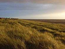
Wolsty is in the civil parish of Holme Low, and the borough of Allerdale. It is located less than half-a-mile from the boundary with the civil parish of Holme St. Cuthbert.[16] The hamlet's parliamentary constituency is Workington, and the MP as of 2016 is Sue Hayman, a representative of the Labour Party who was first elected in 2015. Wolsty is just outside the southern stretch of the Solway Coast Area of Outstanding Natural Beauty.[17] Wolsty Banks, the area of sand dunes between the hamlet and the sea on the far side of the B5300 coast road, was a designated Site of Special Scientific Interest in 1991, along with nearby Mawbray Banks.[18] The Banks were damaged by a fire in 2013, and could take several years to recover.[19]
Climate
Wolsty, like the rest of the Solway Plain, has an oceanic climate, Köppen climate classification Cfb, with warm summers and cool winters which generally avoid extremes of temperature. Due to its coastal location, Wolsty receives less snowfall than the mountainous Lake District further south in the county. The average high temperature in 19 degrees Celsius in July and August, and the average low temperature is 2 degrees Celsius in December, January, and February. Rainfall is year-round, but more common in the autumn and winter months.
| Climate data for Wolsty | |||||||||||||
|---|---|---|---|---|---|---|---|---|---|---|---|---|---|
| Month | Jan | Feb | Mar | Apr | May | Jun | Jul | Aug | Sep | Oct | Nov | Dec | Year |
| Average high °C (°F) | 7 (45) |
7 (45) |
9 (48) |
12 (54) |
15 (59) |
17 (63) |
19 (66) |
19 (66) |
17 (63) |
13 (55) |
9 (48) |
6 (43) |
12.5 (54.5) |
| Average low °C (°F) | 2 (36) |
2 (36) |
3 (37) |
4 (39) |
7 (45) |
9 (48) |
12 (54) |
12 (54) |
9 (48) |
7 (45) |
4 (39) |
2 (36) |
6 (43) |
| Average precipitation mm (inches) | 93.6 (3.685) |
105.1 (4.138) |
72.0 (2.835) |
63.5 (2.5) |
60.1 (2.366) |
70.3 (2.768) |
58.4 (2.299) |
76.2 (3) |
73.4 (2.89) |
109.4 (4.307) |
93.2 (3.669) |
102.5 (4.035) |
977.7 (38.492) |
| Source: [20] | |||||||||||||
References
- ↑ "Google Maps – Wolsty". Retrieved 24 February 2015.
- ↑ Holme St. Cuthbert History Group (2004). Plain People: Bygone Times on the Solway Plain. ISBN 0954882318.
- ↑ "Pastscape.org – Milefortlet 13". Retrieved 24 February 2015.
- ↑ "Holme Low Parish Council – Wolsty Castle". Retrieved 24 February 2015.
- ↑ "English Heritage – Wolsty Castle". Retrieved 24 February 2015.
- ↑ "Holme Low Parish Council – Wolsty Castle". Retrieved 24 February 2015.
- ↑ "Grampus – St Christian's Chapel and Wolsty Castle geophysical surveys and excavations". Retrieved 24 February 2015.
- ↑ "British History Online – Records of the Holme Under Elizabeth". Retrieved 24 February 2015.
- ↑ "Holme Low Parish Council – Local History". Retrieved 24 February 2015.
- ↑ "Holme St. Cuthbert History Group – Causewayhead". Retrieved 24 February 2015.
- ↑ "The Co-operative Food – Silloth". Retrieved 24 February 2015.
- ↑ "Solway Coast AONB – Spar, Silloth". Retrieved 24 February 2015.
- ↑ "Reays City Hopper route 60 – Timetable" (PDF). Retrieved 24 February 2015.
- ↑ "The Gincase". Retrieved 24 February 2015.
- ↑ "Bank Mill Nurseries". Retrieved 24 February 2015.
- ↑ "Cumbria Geography Atlas – Parish Boundaries".
- ↑ "Solway Coast AONB – Location". Retrieved 24 February 2015.
- ↑ "Natural England – SSSI Citation" (PDF). Retrieved 24 February 2015.
- ↑ "BBC News – Wolsty Banks fire damage 'long-lasting'". Retrieved 24 February 2015.
- ↑ "World Weather Online – Wolsty". Retrieved 24 February 2015.
External links
| Wikimedia Commons has media related to Wolsty. |