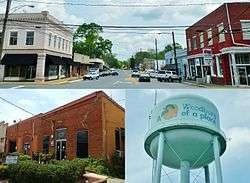
Woodbury, Georgia
| Woodbury, Georgia | |
|---|---|
| City | |
|
"A Peach of a Place" | |
 Location in Meriwether County and the state of Georgia | |
| Coordinates: 32°58′50″N 84°34′52″W / 32.98056°N 84.58111°WCoordinates: 32°58′50″N 84°34′52″W / 32.98056°N 84.58111°W | |
| Country | United States |
| State | Georgia |
| County | Meriwether |
| Area | |
| • Total | 2 sq mi (5.2 km2) |
| • Land | 2 sq mi (5.2 km2) |
| • Water | 0 sq mi (0 km2) |
| Elevation | 827 ft (252 m) |
| Population (2000) | |
| • Total | 1,184 |
| • Density | 592/sq mi (227.7/km2) |
| Time zone | Eastern (EST) (UTC-5) |
| • Summer (DST) | EDT (UTC-4) |
| ZIP code | 30293 |
| Area code(s) | 706 |
| FIPS code | 13-83896[1] |
| GNIS feature ID | 0333457[2] |
Woodbury is a town in Meriwether County, Georgia, United States. The population was 1,184 at the 2000 census.
History
Woodbury is one of the oldest towns in Meriwether County. It grew up about ten miles southeast of Greenville in the late 1820s. It was first named Sandtown for the white sand that covered the ground. When the post office opened in 1845, the PO department changed the name to Woodberry. By 1854, the spelling was officially changed to Woodbury. The small town of Woodbury hit a growth spurt in 1887 when the railroad laid its tracks and made its mark. Around the start of the 20th century, Woodbury had tremendous growth with schools, churches, and businesses serving the many new residents.
Geography
Woodbury is located at 32°58′50″N 84°34′52″W / 32.98056°N 84.58111°W (32.980588, -84.580979).[3]
According to the United States Census Bureau, the city has a total area of 2.0 square miles (5.2 km²), of which 2.0 square miles (5.2 km²) is land and 0.50% is water.
Demographics
| Historical population | |||
|---|---|---|---|
| Census | Pop. | %± | |
| 1880 | 94 | — | |
| 1890 | 369 | 292.6% | |
| 1900 | 566 | 53.4% | |
| 1910 | 917 | 62.0% | |
| 1920 | 923 | 0.7% | |
| 1930 | 849 | −8.0% | |
| 1940 | 865 | 1.9% | |
| 1950 | 985 | 13.9% | |
| 1960 | 1,230 | 24.9% | |
| 1970 | 1,422 | 15.6% | |
| 1980 | 1,738 | 22.2% | |
| 1990 | 1,429 | −17.8% | |
| 2000 | 1,184 | −17.1% | |
| 2010 | 961 | −18.8% | |
| Est. 2015 | 909 | [4] | −5.4% |
_Red_Oak_Creek%2C_Huel_Brown_Road_(Cov%2C_Woodbury_vicinity_(Meriwether_County%2C_Georgia).jpg)
As of the census[1] of 2000, there were 1,184 people, 454 households, and 302 families residing in the city. The population density was 588.7 people per square mile (227.4/km²). There were 499 housing units at an average density of 248.1 per square mile (95.9/km²). The racial makeup of the city was 42.40% White, 56.50% African American, and 1.10% from two or more races. Hispanic or Latino of any race were 0.68% of the population.
There were 454 households out of which 27.5% had children under the age of 18 living with them, 37.7% are married couples. Together, 22.9% had a female householder with no husband present, and 33.3% were non-families. 30.8% of all households were made up of individuals and 17.4% had someone living alone who was 65 years of age or older. The average household size was 2.61 and the average family size was 3.31.
In the city, the population was spread out with 24.7% under the age of 18, 10.3% from 18 to 24, 23.1% from 25 to 44, 25.1% from 45 to 64, and 16.8% who were 65 years of age or older. The median age was 38 years. For every 100 females there were 86.8 males. For every 100 females age 18 and over, there were 81.7 males.
The median income for a household in the city was $26,339, and the median income for a family was $31,389. Males had a median income of $26,563 versus $18,287 for females. The per capita income for the city was $12,162. About 24.8% of families and 25.4% of the population were below the poverty line, including 33.2% of those under age 18 and 24.9% of those age 65 or over.
In popular culture
- Woodbury is featured prominently in The Walking Dead franchise as a fortified survivor settlement run by a leader called the Governor during a zombie apocalypse. However, in the television series of the same name, the Woodbury scenes are filmed in Senoia, Georgia.[6]
- The Red Oak Creek Covered Bridge near Woodbury was the backdrop for the climactic scene of the 2012 film Lawless.
References
- 1 2 "American FactFinder". United States Census Bureau. Retrieved 2008-01-31.
- ↑ "US Board on Geographic Names". United States Geological Survey. 2007-10-25. Retrieved 2008-01-31.
- ↑ "US Gazetteer files: 2010, 2000, and 1990". United States Census Bureau. 2011-02-12. Retrieved 2011-04-23.
- ↑ "Annual Estimates of the Resident Population for Incorporated Places: April 1, 2010 to July 1, 2015". Retrieved July 2, 2016.
- ↑ "Census of Population and Housing". Census.gov. Retrieved June 4, 2015.
- ↑ "The Walking Dead". IMDb. Retrieved 6 July 2016.
Municipalities and communities of Meriwether County, Georgia, United States | ||
|---|---|---|
| Cities |  | |
| Towns | ||
| Unincorporated community | ||
| Footnotes | ‡This populated place also has portions in an adjacent county or counties | |