Wootton, Northamptonshire
| Wootton | |
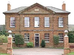 The former Northamptonshire Regiment's and Royal Pioneer Corps' "Simpson Barracks" at the former Workhouse building in Hardingstone[1] now housing called Regency Place, Wootton, Northampton |
|
 Wootton |
|
| Population | 11,180 (Nene Valley Ward) |
|---|---|
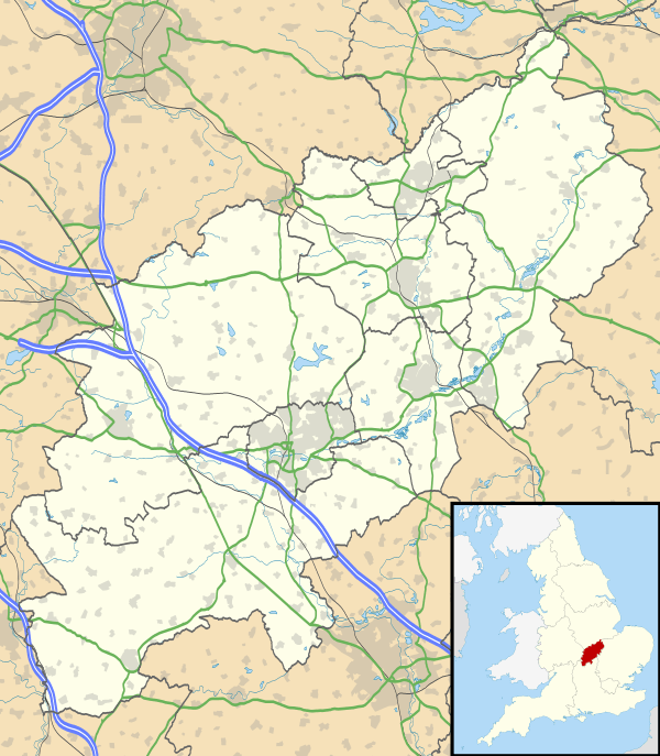
| OS grid reference | SP762564 |
| District | Northampton |
| Shire county | Northamptonshire |
| Region | East Midlands |
| Country | England |
| Sovereign state | United Kingdom |
| Post town | Northampton |
| Postcode district | NN4 |
| Dialling code | 01604 |
| Police | Northamptonshire |
| Fire | Northamptonshire |
| Ambulance | East Midlands |
| EU Parliament | East Midlands |
| UK Parliament | South Northamptonshire |
|
|
Coordinates: 52°12′02″N 0°53′08″W / 52.20066°N 0.88569°W
Wootton is a former village about 3 miles (4.8 km) south of Northampton town centre that is now part of the Northampton Borough Council area.
Wootton is separated from Hardingstone by the Newport Pagnell Road the B526, formerly part of the A50 road. Part of Wootton is alongside the A45 dual carriageway from the M1 to Wellingborough which is seen and heard from that part of the area.
History
Domesday Book
In the Domesday Book, Wootton is described as "Wetone". It later became Weton, Wutton and then Witton. "Wootton" appeared in the 14th century. The names probably have the Saxon origin of "Wudutun" and mean settlement or farmstead in, or by, a wood, which may have been Salcey Forest.
Church
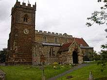
The thirteenth century Parish Church of St. George, The Martyr, stands in the High Street in a conservation area and is a Group 1 listed building. It was restored in 1865.[2] It was again restored and re-dedicated in 1991 after a £93,000 restoration programme had been successfully completed.
The Rectory, west of the church is dated 1630.[2] A memorial in the south wall is to the wife of John Harris – the Lord of the Manor in the eighteenth century.
17th and 18th centuries
Little of Wootton dates from earlier than Stuart times. Most of the stone houses are late 17th or early 18th century. Many of these houses were originally thatched, as can be seen from the steep pitch of the roof.
Many brick cottages are at least as old with those in Church Hill, at least 1770's, as they are mentioned in the Enclosure Act of 1779. Wootton had its own brick works along Berry Lane. A nearby field was known as Clay Pit field as late as 1932, but even in 1899, it was known as the "Old" Brick Works and used for many years as an ash tip. The Department of the Environment listed Carey's Cottage in Berry Lane as 16th century.
Royal Pioneer Corps
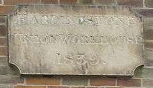
The Northamptonshire Regiment and later Royal Pioneer Corps were stationed at the former Quebec Barracks, later renamed Simpson Barracks[3] on a large site adjacent to the Newport Pagnell Road which include the old Hardingstone workhouse building[1] which dates from 1839.[2]
The Barracks closed on 1 April 1993 and the site is now used for a housing estate, including the old workhouse, many road names reflecting its military origin. During the war the corps had an ammunition dump hidden in woods at Yardley Chase, where signs still remain.
1980s urban expansion
The village backs on to a several modern housing estates including Wootton Fields and the area previously occupied by an army barracks. The development and loss of village character occurred during the 1980s and 1990s as the town expanded south towards the M1 motorway near junction 15 and is next to the large housing estates of Wootton Fields, Grange Park, Simpson Manor and East Hunsbury.
2008 expansion proposals
Further urban expansion of Northampton was being planned in October 2008 with another 13,500 houses and additional infrastructure in the rural areas around Grange Park, Quinton and Preston Deanery.[4]
2011 murder of the Ding family
See: 2011 murder of the Ding family
Governance
As a former village distinct from the town, it has its own Parish Council, unlike more recent 20th and 21st century suburbs of the town. The parish includes East Hunsbury, a rural part of the parish before development in the 1980s.[5] The village is in the Nene Valley two-member ward of Northampton Borough Council and in the Nene Valley single-member division of Northamptonshire County Council.
Demographics
The 2001 census[6] showed there were 2,015 people living in the parish, 978 male, 1,037 female in 885 dwellings. The 2011 Census showed that the ward had expanded rapidly to 11,180.[7]
Facilities
There is a community centre, a recreation ground with multi-use games area, a Working men's club; opticians and a medical centre.
Wootton has two pub/restaurants – "The Yeoman of Old England" in the centre of what was the old village. The second, "The Queen Eleanor" together with a Premier Inn hotel are both on Newport Pagnell road near the Queen Eleanor junction of Mereway and the A45. There is a shop, butcher, chemist and a large Wyevale Garden Centre in Newport Pagnell Road. Waitrose also said they would like to build a supermarket on the road but this was opposed in a report commissioned by the West Northampton Development Corporation.[8] However, in 2013, plans were approved for a new Waitrose store[9] and it is expected to open by Christmas, 2013.[10]
The village primary school is Wootton County founded in 1873. A modern all-through Caroline Chisholm School for young people aged 4–19 is located on Wooldale Road. The private Northampton High School for girls is located along Newport Pagnell Road.
References
- 1 2 "Hardingstone Union Workhouse". Retrieved 9 November 2014.
- 1 2 3 Pevsner, Nikolaus (1961). The Buildings of England – Northamptonshire. London and New Haven: Yale University Press. p. 470. ISBN 978-0-300-09632-3.
- ↑ "Simpson Barracks of the Royal Pioneer Corps". Retrieved 8 October 2008.
- ↑ "13,500 new homes proposed for Northampton suburb". Retrieved 24 October 2008.
- ↑ "Wootton and Hunsbury Parish Council". Retrieved 25 September 2008.
- ↑ "UK census 2001 – data for Nene Valley Ward which includes Collingtree and East Husbury". Retrieved 3 October 2008.
- ↑ "Northampton Ward population 2011". Neighbourhood Statistics. Office for National Statistics. Retrieved 13 July 2016.
- ↑ "Report reveals £360m spent in Northampton’s top supermarkets, but adds no more should be built" - Northampton Chronicle & Echo 28 May 2011
- ↑ Northampton Chronicle & Echo New Northampton Waitrose to open within 18 months 10 February 2013, accessed 17 April 2013
- ↑ Waitrose website showing new locations, accessed 17 April 2013
External links
![]() Media related to Wootton, Northamptonshire at Wikimedia Commons
Media related to Wootton, Northamptonshire at Wikimedia Commons
- Northampton Borough Council
- Northamptonshire County Council
- Caroline Chisholm School in Wooldale Road, Wootton
- Pocket park website
- Preston Hedges Primary School, Wootton Hope Drive
- Wootton St George Football club
- Wootton & East Hunsbury Parish Council
- Map sources for Wootton, Northamptonshire
The Borough of Northampton | |||||||||||||||||||
|---|---|---|---|---|---|---|---|---|---|---|---|---|---|---|---|---|---|---|---|
| Suburbs and villages |  | ||||||||||||||||||
| Governance | |||||||||||||||||||
| Culture |
| ||||||||||||||||||
| Education | |||||||||||||||||||
| Sport |
| ||||||||||||||||||
| Transport | |||||||||||||||||||
| |||||||||||||||||||