Worton, Maryland
| Worton, Maryland | |
|---|---|
| Census-designated place | |
 Worton | |
| Coordinates: 39°16′28″N 76°05′32″W / 39.27444°N 76.09222°WCoordinates: 39°16′28″N 76°05′32″W / 39.27444°N 76.09222°W | |
| Country | United States |
| State | Maryland |
| County | Kent |
| Elevation | 72 ft (22 m) |
| Time zone | Eastern (EST) (UTC-5) |
| • Summer (DST) | EDT (UTC-4) |
| ZIP code | 21678 |
| Area code(s) | 410, 443, and 667 |
| GNIS feature ID | 591611[1] |
Worton is an unincorporated community and census-designated place in Kent County, Maryland, United States.[1] Worton is located along Maryland Route 297 at the crossing of the Maryland and Delaware Railroad north of Chestertown. Christ Church, Graveyard and Sexton's House was listed on the National Register of Historic Places in 1980.[2]
References
- 1 2 "Worton". Geographic Names Information System. United States Geological Survey.
- ↑ National Park Service (2010-07-09). "National Register Information System". National Register of Historic Places. National Park Service.
Municipalities and communities of Kent County, Maryland, United States | ||
|---|---|---|
| Towns | 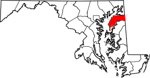 | |
| CDPs | ||
| Unincorporated communities | ||
| Footnotes | ‡This populated place also has portions in an adjacent county or counties | |
This article is issued from Wikipedia - version of the 10/28/2016. The text is available under the Creative Commons Attribution/Share Alike but additional terms may apply for the media files.