Betterton, Maryland
| Betterton, Maryland | |
|---|---|
| Town | |
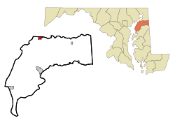 Location of Betterton, Maryland | |
| Coordinates: 39°22′4″N 76°3′39″W / 39.36778°N 76.06083°WCoordinates: 39°22′4″N 76°3′39″W / 39.36778°N 76.06083°W | |
| Country | United States |
| State | Maryland |
| County | Kent |
| Government | |
| • Type | Mayor-Council |
| • Mayor | Donald E. Sutton |
| Area[1] | |
| • Total | 1.00 sq mi (2.59 km2) |
| • Land | 0.99 sq mi (2.56 km2) |
| • Water | 0.01 sq mi (0.03 km2) |
| Elevation | 72 ft (22 m) |
| Population (2010)[2] | |
| • Total | 345 |
| • Estimate (2012[3]) | 339 |
| • Density | 348.5/sq mi (134.6/km2) |
| Time zone | Eastern (EST) (UTC-5) |
| • Summer (DST) | EDT (UTC-4) |
| ZIP code | 21610 |
| Area code(s) | 410 |
| FIPS code | 24-07200 |
| GNIS feature ID | 0583196 |
| Website | townofbetterton.com |
|
Betterton Historic District | |
|
Rigbie Hotel | |
  | |
| Location | Roughly bounded by Sassafras River, Gut Marsh, 6th, and Ericsson Aves., Betterton, Maryland |
|---|---|
| Coordinates | 39°22′2″N 76°3′47″W / 39.36722°N 76.06306°W |
| Built | 1880 |
| Architectural style | Gothic |
| NRHP Reference # | [4] |
| Added to NRHP | June 07, 1984 |

Betterton is a town in Kent County, Maryland, United States. The population was 345 at the 2010 census.
Betterton Historic District
The Betterton Historic District consists of a collection of vernacular Victorian resort structures. The district includes many of the homes, hotels and cottages built to accommodate steamboat passengers in the late 19th and early 20th centuries. Notable buildings within the district include the hotels and boarding homes which catered to the steamboat passengers, several churches, and summer cottages, dating from the golden age of the passenger steamboats on the Chesapeake Bay.[5]
It was added to the National Register of Historic Places in 1984.[4]
Geography
Betterton is located at the mouth of the Sassafras River on the upper Chesapeake Bay. More precisely, Betterton is located at 39°22′4″N 76°3′39″W / 39.36778°N 76.06083°W (39.367863, -76.060877).[6]
According to the United States Census Bureau, the town has a total area of 1.00 square mile (2.59 km2), of which, 0.99 square miles (2.56 km2) is land and 0.01 square miles (0.03 km2) is water.[1]
Government
Betterton is governed by a mayor and a town council with four members. Town council meetings are held on the second and fourth Tuesday of every month at 7:00 pm in the town hall. The town hall is located in the Betterton Community Center, a former Catholic church refurbished as town offices and a museum, on Main Street.
Betterton Beach
Betterton Beach is located at the foot of Main Street. The beach has 300 feet (91 m) of frontage for swimming. The water is generally free of sea nettles because the water is not very salty. The beach has public restrooms (seasonal), a boardwalk, a fishing jetty, a public landing, and reasonable parking. A picnic pavilion is nearby. Lifeguards service was suspended in 2008, and the public beach is currently "swim at your own risk".
Demographics
| Historical population | |||
|---|---|---|---|
| Census | Pop. | %± | |
| 1910 | 308 | — | |
| 1920 | 327 | 6.2% | |
| 1930 | 296 | −9.5% | |
| 1940 | 221 | −25.3% | |
| 1950 | 314 | 42.1% | |
| 1960 | 328 | 4.5% | |
| 1970 | 327 | −0.3% | |
| 1980 | 356 | 8.9% | |
| 1990 | 360 | 1.1% | |
| 2000 | 376 | 4.4% | |
| 2010 | 345 | −8.2% | |
| Est. 2015 | 325 | [7] | −5.8% |
2010 census
As of the census[2] of 2010, there were 345 people, 156 households, and 88 families residing in the town. The population density was 348.5 inhabitants per square mile (134.6/km2). There were 317 housing units at an average density of 320.2 per square mile (123.6/km2). The racial makeup of the town was 92.5% White, 2.9% African American, 0.9% Native American, 0.6% Asian, 1.7% from other races, and 1.4% from two or more races. Hispanic or Latino of any race were 2.9% of the population.
There were 156 households of which 23.7% had children under the age of 18 living with them, 41.0% were married couples living together, 8.3% had a female householder with no husband present, 7.1% had a male householder with no wife present, and 43.6% were non-families. 36.5% of all households were made up of individuals and 10.2% had someone living alone who was 65 years of age or older. The average household size was 2.21 and the average family size was 2.94.
The median age in the town was 46.9 years. 18.6% of residents were under the age of 18; 8.4% were between the ages of 18 and 24; 20.3% were from 25 to 44; 36.7% were from 45 to 64; and 15.9% were 65 years of age or older. The gender makeup of the town was 49.3% male and 50.7% female.
2000 census
As of the census[9] of 2000, there were 376 people, 164 households, and 102 families residing in the town. The population density was 423.9 people per square mile (163.1/km²). There were 277 housing units at an average density of 312.3 per square mile (120.2/km²). The racial makeup of the town was 92.29% White, 2.13% African American, 4.52% from other races, and 1.06% from two or more races. Hispanic or Latino of any race were 8.24% of the population.
There were 164 households out of which 29.3% had children under the age of 18 living with them, 47.0% were married couples living together, 11.6% had a female householder with no husband present, and 37.8% were non-families. 34.1% of all households were made up of individuals and 11.6% had someone living alone who was 65 years of age or older. The average household size was 2.29 and the average family size was 2.94.
In the town the population was spread out with 26.1% under the age of 18, 8.8% from 18 to 24, 25.8% from 25 to 44, 25.8% from 45 to 64, and 13.6% who were 65 years of age or older. The median age was 39 years. For every 100 females there were 88.9 males. For every 100 females age 18 and over, there were 86.6 males.
The median income for a household in the town was $36,477, and the median income for a family was $38,750. Males had a median income of $31,250 versus $27,188 for females. The per capita income for the town was $24,848. About 6.1% of families and 6.8% of the population were below the poverty line, including 9.5% of those under age 18 and 9.5% of those age 65 or over.
References
- 1 2 "US Gazetteer files 2010". United States Census Bureau. Archived from the original on 2012-07-14. Retrieved 2013-01-25.
- 1 2 "American FactFinder". United States Census Bureau. Retrieved 2013-01-25.
- ↑ "Population Estimates". United States Census Bureau. Archived from the original on 2013-06-17. Retrieved 2013-06-26.
- 1 2 National Park Service (2008-04-15). "National Register Information System". National Register of Historic Places. National Park Service.
- ↑ Maryland Historical Trust: Listing for Betterton Historic District
- ↑ "US Gazetteer files: 2010, 2000, and 1990". United States Census Bureau. 2011-02-12. Retrieved 2011-04-23.
- ↑ "Annual Estimates of the Resident Population for Incorporated Places: April 1, 2010 to July 1, 2015". Retrieved July 2, 2016.
- ↑ "Census of Population and Housing". Census.gov. Archived from the original on May 11, 2015. Retrieved June 4, 2015.
- ↑ "American FactFinder". United States Census Bureau. Archived from the original on 2013-09-11. Retrieved 2008-01-31.
External links
- Betterton's Page at the Maryland Municipal League
- Betterton's Page at the Kent County Website
- Betterton's website link listed at the Kent County Website
- Betterton Beach
- Betterton Historic District, Kent County, including photo dated 1984, at Maryland Historical Trust
- Boundary Map of the Betterton Historic District, Kent County, at Maryland Historical Trust
| Topics |   | |
|---|---|---|
| Lists by county | ||
| Lists by city | ||
| Other lists | ||
| ||
Municipalities and communities of Kent County, Maryland, United States | ||
|---|---|---|
| Towns | 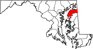 | |
| CDPs | ||
| Unincorporated communities | ||
| Footnotes | ‡This populated place also has portions in an adjacent county or counties | |