Y-Bridge (Zanesville, Ohio)
|
Y Bridge | |
|
The Zanesville Y-Bridge, seen from a high bluff south of the river confluence. | |
  | |
| Location |
|
|---|---|
| Coordinates | 39°56′25.5″N 82°0′51.5″W / 39.940417°N 82.014306°WCoordinates: 39°56′25.5″N 82°0′51.5″W / 39.940417°N 82.014306°W |
| Area | 2 acres (0.81 ha) |
| Built | 1902 |
| NRHP Reference # | 73001516[1] |
| Added to NRHP | November 2, 1973 |
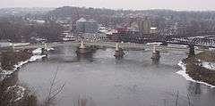
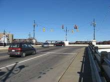
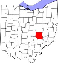
The Zanesville Y-Bridge is a historic Y-shaped three-way bridge that spans the confluence of the Licking and Muskingum Rivers in downtown Zanesville, Ohio. It carries the traffic of U.S. Route 40 (Main Street and West Main Street), as well as Linden Avenue.
When being given directions, visitors are often surprised by the statement "Drive to the middle of the bridge and turn left (or right)."
History
The flow of Muskingum has been regulated by a series of dams and locks since the mid-19th century. Before the regulation serious floods often occurred, which washed away or weakened the earliest bridges.
The first Zanesville Y-Bridge was constructed in 1814. The trestle bridge stood for four years. The second wooden bridge was erected in 1819. New roads were built in the area and traffic increased. A winter flood in 1831–1832 weakened the second bridge to be unsafe for the increased traffic. A third iteration, a wooden covered bridge was completed in 1832 and stood until 1900.
The next bridge opened in early 1902. It had concrete balustrade railings which were lost to the 1913 flood and replaced with pipe railings. The fourth bridge was deemed unsafe in 1979. After demolition it was found that only one of the three segments needed actual replacement, the other spans would have needed only surface repairs.
The current concrete and steel bridge is the fifth in the series on the same location. It opened in 1984. While being a relief to traffic and the citizens, it has received criticism for a tunnel-like effect due to its solid railings, providing hardly any view of the scenery.
The bridge appears in the National Register of Historic Places listings in Muskingum County, Ohio
See also
-
 Bridges portal
 -
 Ohio portal
Notes
- ↑ National Park Service (2008-04-15). "National Register Information System". National Register of Historic Places. National Park Service.
References
- "City of Zanesville History" City of Zanesville, Ohio.
Further reading
- Schneider, Norris (1950). Y-Bridge City: The Story of Zanesville and Muskingum County, Ohio. Zanesville, Ohio: World Publishing Company.
External links
| Historic districts |
|  |
|---|---|---|
| Other properties |
| |
| Formerly listed |
| |