Y Garn (Nantlle Ridge)
| Y Garn | |
|---|---|
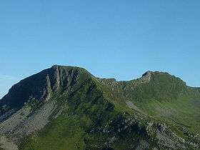 Y Garn (left) and Mynydd Drws-y-Coed (right) from Mynydd Mawr | |
| Highest point | |
| Elevation | 633 m (2,077 ft) |
| Prominence | 21 m (69 ft) |
| Listing | sub Hewitt, Nuttall |
| Geography | |
| Location | Gwynedd, Wales |
| Parent range | Moel Hebog |
| Topo map | OS Landranger 115, OS Outdoor Leisure 17 |
| Climbing | |
| Easiest route | Walk |
Y Garn is a top of Mynydd Drws-y-Coed in Snowdonia, north Wales and is the easterly end of the Nantlle Ridge.[1]
It has steep north facing cliffs, the summit area being the highest point on a broad rocky plateau. The summit plateau contains two large shelter cairns.[2]
References
- ↑ Nuttall, John & Anne (1999). The Mountains of England & Wales - Volume 1: Wales (2nd edition ed.). Milnthorpe, Cumbria: Cicerone. ISBN 1-85284-304-7.
- ↑ Crocker, Chris; Graham Jackson. "Mountaineering & Rock Climbing in the UK: Y Garn". Database of British Hills. Mountain Days.net. Retrieved 2008-04-08.
Coordinates: 53°03′05″N 04°09′45″W / 53.05139°N 4.16250°W
This article is issued from Wikipedia - version of the 1/24/2016. The text is available under the Creative Commons Attribution/Share Alike but additional terms may apply for the media files.