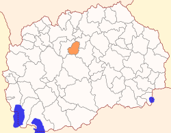
Zelenikovo Municipality
| Municipality of Zelenikovo Општина Зелениково | |
|---|---|
| Rural municipality | |
 | |
| Country |
|
| Region | Skopje Statistical Region |
| Municipal seat | Zelenikovo |
| Government | |
| • Mayor | Vele Gruevski (VMRO-DPMNE) |
| Area | |
| • Total | 176.95 km2 (68.32 sq mi) |
| Population (2002) | |
| • Total | 4,077 |
| • Density | 23/km2 (60/sq mi) |
| Time zone | CET (UTC+1) |
| Area code(s) | 02 |
| Car Plates | SK |
Zelenikovo Municipality (Macedonian: ![]() Зелениково ) is a municipality in central part of Republic of Macedonia. The municipal seat is located in the village Zelenikovo. The municipality is located in the Skopje Statistical Region.
Зелениково ) is a municipality in central part of Republic of Macedonia. The municipal seat is located in the village Zelenikovo. The municipality is located in the Skopje Statistical Region.
Geography
The municipality borders Studeničani Municipality to the west, Petrovec Municipality to the northeast, Čaška Municipality to the south, and Veles Municipality to the southeast.
Demographics
According to the 2002 Macedonian census, Zelenikovo Municipality has 4,077 inhabitants.[1] Ethnic groups in the municipality:
- Macedonians = 2,522 (61.9%)
- Albanians = 1,206 (29.6%)
- Bosniaks = 191 (4.7%)
- others.
Inhabited places
| Inhabited places in Zelenikovo Municipality | ||
|---|---|---|
| villages: Vražale (Вражале) | Gradovci (Градовци) | Gumalevo (Гумалево) | Dejkovec (Дејковец) | Dobrino (Добрино) | Smesnica (Смесница) | Orešani (Орешани) | Pakoševo (Пакошево) | Paligrad (Палиград) | Novo Selo (Ново Село) | Strahodjadica (Страхојадица) | Taor (Таор) | Tisovica (Тисовица) |Zelenikovo (Зелениково) | ||
References
- ↑ 2002 census results in English and Macedonian (PDF)
External links
Coordinates: 41°52′59″N 21°35′22″E / 41.88306°N 21.58944°E
This article is issued from Wikipedia - version of the 11/12/2015. The text is available under the Creative Commons Attribution/Share Alike but additional terms may apply for the media files.