Zone 1 of Milan
| Zona 1 of Milan | |
|---|---|
| Zona of Milan | |
|
| |
 Location of Zone 1 of Milan | |
| Country |
|
| Region | Lombardy |
| Province | Metro City of Milan |
| Comune | Milan |
| Government | |
| • President | Fabio Arrigoni (PD) |
| Area | |
| • Total | 3.71 sq mi (9.62 km2) |
| Population (2013) | |
| • Total | 96,315 |
| • Density | 28,680/sq mi (11,074/km2) |
| Time zone | CET (UTC+1) |
| • Summer (DST) | CEST (UTC+2) |
The Zone 1 of Milan (in Italian: Zona 1 di Milano) is one of the 9 administrative zones of Milan, Italy.[1]
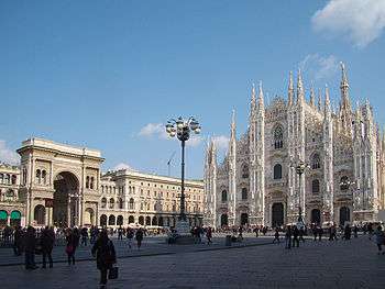
The zone includes the historical center of the city. It is the least populated of the city's zones and one of the smallest by area, a significant part of which is occupied by the Piazza del Duomo, the Castello Sforzesco and Sempione Park. Much of the remainder of the zone is dedicated to museums and administration buildings.
Subdivision
The zone includes the following quarters:
- Brera, which houses the Brera Academy of Fine Arts and the Brera Art Gallery, which prominently contributed to the development of Brera as an artists' neighborhood and a place of bohemian atmosphere, sometimes referred to as "the milanese Montmartre".[2] Both the Academy and the Gallery are located in Palazzo Brera, the main historical building of the area; this same building also houses Milan's botanical garden as well as an astronomical observatory and the Braidense National Library. Other features that contribute to the character of Brera include restaurants, bars, night clubs, antique and art shops, colorful street markets, as well as fortune tellers' booths;
- Porta Sempione, a prominent historic district that also includes part of Corso Sempione, a large avenue leading to Porta Sempione from the northwest. The main landmark of this area is the Sforza Castle, which dominates the Simplon Park, the largest and most important city park in the centre of Milan. The park houses other renowned monuments and places of interest, such as the Branca Tower, the Palazzo dell'Arte (one of the seats of the Triennale art expo), sculptures by Giorgio de Chirico, and the public aquarium. The whole area is one of the centres of the so-called Milanese movida (night life), with a number of bars, pubs, restaurants, and discos; since the RAI public television company, as well as some major radio stations, have their headquarters in the area, frequent appearances of celebrities contribute to the popularity of the Sempione's night life venues;[3]
- Porta Tenaglia;
- Centro Storico;
- Conca del Naviglio;
- Guastalla.
Education
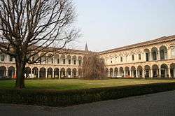

Thanks to its central position, the Zona 1 houses some prominent educational institutions. In this area there are the main buildings of two universities:
- University of Milan, founded in 1924, is located not so far from the Piazza del Duomo. At the end of the Second World War, the old Ospedale dei Poveri (Hospital for the Poor) building, known as "la Cà Granda" (the Big House), was assigned to the University. The building, one of the first Italian examples of civil architecture - commissioned in the 15th century by the Sforza family, the dukes of Milan - was seriously damaged by the bombings of 1943. In 1958, after a complex series of reconstruction and renovation works, it became home to the University Rector's Office, the administrative offices and the schools of Law and Humanities.
- Brera Academy of Fine Arts, founded in 1776 by Maria Theresa of Austria, is located in the Brera district. It shared premises with other cultural and scientific institutions – the astronomical observatory, the Orto Botanico di Brera, the Scuole Palatine for philosophy and law, the Gymnasium, laboratories for physics and chemistry, the Biblioteca di Brera, the agricultural society and, from 1806, the Pinacoteca di Brera or art gallery. These were housed in the Palazzo Brera, which was built in about 1615 to designs by Francesco Maria Richini and until the suppression of the Jesuits in 1773 had been a Jesuit college.
Transport
Stations of Milan Metro in the Zona 1:
 Cadorna, Cairoli, Cordusio, Duomo, Palestro, Porta Venezia, San Babila;
 Cadorna, Lanza, Moscova;
 Crocetta, Duomo, Missori, Montenapoleone, Porta Romana, Turati.

The Zona 1 is also interested by Milan Area C, a congestion charge introduced on January 16, 2012, replacing the previous pollution charge Ecopass and based on the same designated traffic restricted zone or ZTL (Italian: Zona a Traffico Limitato), corresponding to the central Cerchia dei Bastioni area.[4] The ZTL encompasses about 8.2 km2 (3.2 sq mi) and 77,000 residents (4.5% and 6% of the city total, respectively).[5] The area is accessible through 43 gates, monitored by video cameras. Area C started as an 18-month pilot program based on the partial implementation of the results of a referendum that took place on June 2011. The objective of the program was to drastically reduce the chronic traffic jams that take place in the city of Milan, to promote sustainable mobility and public transport, and to decrease the existing levels of smog that have become unsustainable from the point of view of public health. Area C was definitively approved as a permanent program on 27 March 2013.[6]
Notable places
- Piazza del Duomo and the cathedral;
- La Scala opera house;
- Galleria Vittorio Emanuele II, the world's oldest shopping mall;
- Palazzo Marino, city hall;
- Via Montenapoleone, luxury shopping street;
- Quadrilatero della moda fashion district;
- Piazza Cordusio;
- Royal Palace of Milan;
- Piccolo Teatro;
- Palazzo Mezzanotte, seat of the Italian stock exchange;
- Sempione Park, the main park in the city center;
- Brera Academy and Brera Art Gallery;
- Castello Sforzesco;
- Velasca Tower.
Gallery
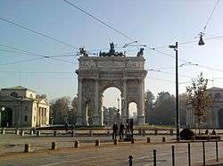 Tha Arch of Peace in Porta Sempione
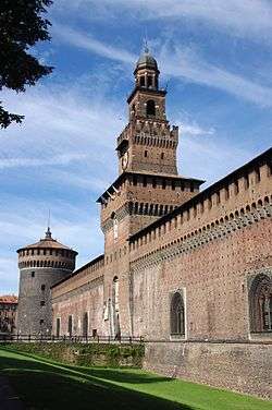 Castello Sforzesco main tower
- La Scala opera house
- A street in Brera district
.jpg)
Maps
 Map of Zona 1
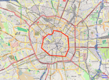 Area C traffic restricted zone (ZTL)
References
- ↑ (Italian) The 9 city councils of Milan (municipal website)
- ↑ Fiori Chiari Archived January 1, 2011, at the Wayback Machine. (one of the best known streets in Brera)
- ↑ Il camper del Corriere al Sempione
- ↑ "Area C è partita: calate del 40% le auto in centro dopo l'entrata in vigore del pedaggio" [Area C takes off: auto traffic decreased 40% in the center after the toll goes into force]. Corriere della Sera Milano (in Italian). 16 January 2012. Retrieved 16 January 2012.
- ↑ Martino, Angelo. "Milano: from pollution charge to congestion charge" (PDF). Retrieved 17 January 2012.
- ↑ "Area C. Istituita la congestion charge definitiva". Comune di Milano. Retrieved 13 May 2013.
External links
| Wikivoyage has a travel guide for Centro Storico di Milano. |
![]() Media related to Zone 1 of Milan at Wikimedia Commons
Media related to Zone 1 of Milan at Wikimedia Commons
- (Italian) Zone 1 of Milan (municipal website)
Coordinates: 45°28′17″N 9°11′06″E / 45.471282°N 9.184999°E
