Ñuble Province
| Ñuble Provincia Provincia de Ñuble | ||
|---|---|---|
| Province | ||
| ||
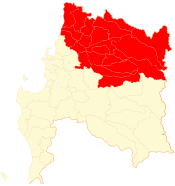 Location in the Bío Bío Region | ||
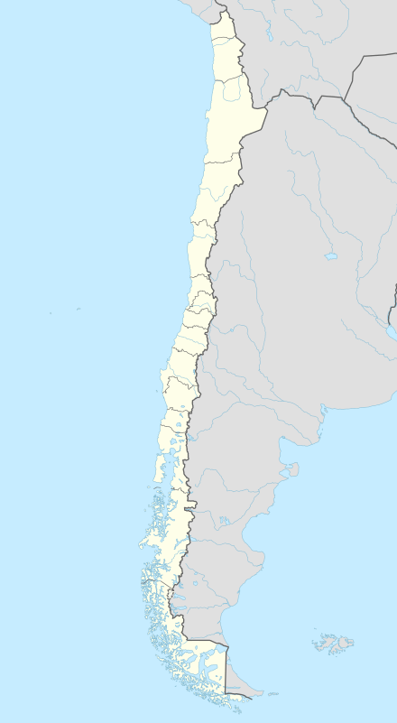 Ñuble Provincia Location in Chile | ||
| Coordinates: 36°37′S 71°57′W / 36.617°S 71.950°WCoordinates: 36°37′S 71°57′W / 36.617°S 71.950°W | ||
| Country | Chile | |
| Region | Bío Bío | |
| Capital | Chillán | |
| Communes | ||
| Government | ||
| • Type | Provincial | |
| • Governor | Ignacio Marín Correa | |
| Area[1] | ||
| • Total | 13,178.5 km2 (5,088.2 sq mi) | |
| Population (2012 Census)[1] | ||
| • Total | 460,113 | |
| • Density | 35/km2 (90/sq mi) | |
| • Urban | 285,108 | |
| • Rural | 152,995 | |
| Sex[1] | ||
| • Men | 217,024 | |
| • Women | 221,079 | |
| Time zone | CLT[2] (UTC-4) | |
| • Summer (DST) | CLST[3] (UTC-3) | |
| Area code(s) | 56 + 42 | |
| Website | Government of Ñuble | |
Ñuble Province (Spanish: Provincia de Ñuble) is one of four provinces of the Chilean region of Bío Bío (VIII). It spans an area of 13,178.5 km2 (5,088 sq mi) and is administratively constituted by 21 communes. It has a population of 441,604 inhabitants. Its capital is the city of Chillán.
History
The province was created in 1848 with the San Carlos Department of Maule Province and Chillán Department of Concepción Province. In 1884, the departments of Bulnes and Yungay, were created from the Chillán Department. In 1927, the provincial limits were modified and the Itata Department was added from Maule. Later, in 1976, the communes of Coelemu and Ránquil from Concepción Province, and the commune of Tucapel from Bío Bío Province, were added.
Following the 8.8 magnitude earthquake and tsunami, at least eight small communities and two towns were abandoned by residents, who took up makeshift camps in the hills, fearful of further tsunamis. Over 800 residences in the town of Quirihue were destroyed, leaving little for townspeople to return to.[4]
Geography and demography
According to the 2002 census by the National Statistics Institute (INE), the province spans an area of 13,178.5 km2 (5,088 sq mi)[1] and had a population of 438,103 inhabitants (217,024 men and 221,079 women), giving it a population density of 33.2/km2 (86/sq mi). It is the seventh most populated province in the country. Of these, 285,108 (65.1%) lived in urban areas and 152,995 (34.9%) in rural areas. Between the 1992 and 2002 censuses, the population grew by 4.5% (18,854 persons).[1]
Culture and tourism
Ñuble has a lot of attractions for tourists, including:
- The Spas of Chillán are a winter and, more importantly, summer tourist complex of the province and the region, located among millenarian forests and inexhaustible thermal water sources.
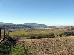
- The comuna of Pinto, located 24 km (15 mi) to the southeast of Chillán, is an agricultural area with some beautiful rural areas where native flora and fauna can be found.
- The Lleuques is a cordillerano bath located next to the Rengado River and which has beautiful places surrounded by mountains.
- Cobquecura located in the coastal sector, and has several beaches and places to make excursions (like the Calvario Hill).
- The commune of Quillón is home of the Avendaño Lagoon, for water-skiing, swimming, sailing, and rowing.
- The commune San Fabián de Alico, has beautiful landscapes is an excellent locality for excursions, camping and fishing.
Other places of interest are the Market and Fair of Chillán, one of the more beautiful and important artisan centers of Chile. Murals by Siqueiros were donated by the Government of Mexico. There is also Bernardo O'Higgins Monumental Park in the locality of Old Chillán.
Among the activities characteristic of Ñuble are crafts, in particular in the localities of Quinchamalí (considered like one of the country's more important places of artisan production of white clay pottery), Coihueco (characterized by the wood carvings and loom weaving), Ninhue and San Fabián de Alico.
In recent years the province of Ñuble has consolidated an important forest sector, thanks to favorable climatic conditions land for the development of plantations of such rapidly growing trees as pinus radiata and eucalyptus globulus.
Ñuble has a variety of celebrations and events. Outstanding among these are the Rodeo, a celebration huasa that takes place between September and February. The Agro-Expo of San Carlos is an agricultural, cattle and artisan exhibition, with strong accent on dairying.
- The Carnival of Quillón, traditional celebration with artistic spectacles and dances.
- The Celebration of the Vendimia, the celebration of autumn in the locality of Santacruz de Cuca.
- The Festival of Creole Roots in Coihueco, which revives folkloric traditions.
- The gathering of Folkloric Roots of Portezuelo in the month of November brings together an important group of singers, artisan and cultural singers and expressions of rural sectors of Ñuble and the country.
- The celebrations of the Cherry and Esquila; this first occurs in December in Quinchamalí, with typical folkloric activities, meals, exhibitions and tasting of cherries, jams and liqueurs; second the Cardal "in the commune of Yungay takes place in the sector".
The province has the pride of being the home of patriots, artists and other men of note, including, Bernardo O'Higgins, Arturo Prat, Claudio Arrau, Ramón Vinay, and Violeta Parra.
Chillán, the capital of Ñuble, may be reached by the following routes:
- By automobile: From Santiago: towards the south by Route 5 (Pan-American Highway), they are 399 km (248 mi) of freeway. From Concepción: towards the east by route 152, they are 112 km (70 mi) of freeway.
- In airplane: Concepción is the nearest airport.
- In train: Terrasur of EFE (the national railway) Av. Brazil s/n Chillán Station.
Administration
As a province, Ñuble is a second-level administrative division of Chile, governed by a provincial governor who is appointed by the president.
Communes
The province comprises 21 communes, each governed by a municipality consisting of an elected alcalde and municipal council.
- Bulnes
- Cobquecura
- Coelemu
- Coihueco
- Chillán
- Chillán Viejo
- El Carmen
- Ninhue
- Ñiquén (San Gregorio de Ñiquén)
- Pemuco
- Pinto
- Portezuelo
- Quillón
- Quirihue
- Ránquil
- San Carlos
- San Fabián
- San Ignacio
- San Nicolás
- Treguaco
- Yungay
Itata Valley wine region
The Itata Valley is a wine region in southern Chile and a Denomination of Origin (DO) is defined by the Chilean Appellation system, the legally defined and protected geographical indication used to identify where the grapes for a wine were grown. The valley is located in the province of Ñuble, 420 kilometres (250 mi) from Santiago, the capital of Chile, and 65 kilometres (40 mi) of the major port of Concepción. It is the northernmost of Chile’s three southern wine regions and stretches roughly 60 miles (100 km) from north to south and a similar distance from east to west, but although it is extensive, it has a low density of vineyard plantations. The area is defined by the convergence of the Itata and Ñuble Rivers, and vineyards plantations are mostly found around the towns of Chillan, Quillon and Coelemu. The valley’s western border is the Pacific Ocean, which has a cooling influence over the valley due the cold Humboldt current that runs along most of Chile’s coastline. The cool Mediterranean climate suits Pais, Muscat of Alexandria and Carignan vines, and more recently, producers have begun to plant more modern grape varieties like Cabernet Sauvignon.
The soils are alluvial, made up of sand and clay from the Itata and Ñuble rivers. The region is located at a latitude of 36°S, a similar distance from the Equator as southern Spain or the central valley of California.[5]
Grape distribution by varietal
- Climate: Cool Mediterranean climate. 1,100 mm (43.3 in) of rain per year.
- Soils: Alluvial soils, clay and sand.
- Primary wines: Cabernet Sauvignon, Pais and Carignan.
| Cabernet Sauvignon: 442 ha (1093 acres) | Moscatel de Alexandria: 5,576 ha (13779 acres) | Mission: 4,572 ha (11298 acres) |
| Carignan: 98 ha (242 acres) | Semillon: 87 ha (215 acres) | |
Total hectares planted: 636 ha (1,572 acres).[6]
See also
References
- 1 2 3 4 5 "Territorial division of Chile" (PDF) (in Spanish). National Statistics Institute. 2007. Retrieved 18 March 2011.
- ↑ "Chile Time". WorldTimeZones.org. Retrieved 2010-07-28.
- ↑ "Chile Summer Time". WorldTimeZones.org. Retrieved 2010-07-28.
- ↑ Mica Rosenberg (3 March 2010). "Fearing tsunamis in Chile, hundreds hide in hills". Reuters. Retrieved 4 March 2010.
- ↑ Itata Valley Wine Published by Wine-Searcher.com | Last updated 02-Aug-2013 by Wine-Searcher Staff retrieved October 25, 2013
- ↑ See Itata Valley Chart www.winesofchile.org all right reserved, retrieved September 23, 2013/

| Cachapoal |  | |
|---|---|---|
| Cardenal Caro | ||
| Colchagua | ||
Provincial capitals in italics • Regional capital in bold | ||