1916 Atlantic hurricane season
| |
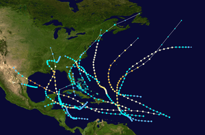
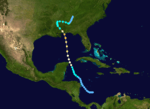
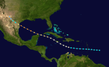
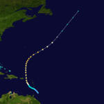
| Season summary map |
| First system formed |
May 13, 1916 |
| Last system dissipated |
November 16, 1916 |
| Strongest storm1 |
"Texas" – 932 mbar (hPa) (27.52 inHg), 130 mph (215 km/h) |
| Total depressions |
18 |
| Total storms |
15 |
| Hurricanes |
10 |
| Major hurricanes (Cat. 3+) |
5 |
| Total fatalities |
107 total |
| Total damage |
$33.3 million (1916 USD) |
| 1Strongest storm is determined by lowest pressure |
Atlantic hurricane seasons
1914, 1915, 1916, 1917, 1918 |
The 1916 Atlantic hurricane season ran through the summer and the first half of fall in 1916. The season is one of only two in which two major hurricanes were reported before the month of August, the other being the 2005 season.
Timeline
Storms
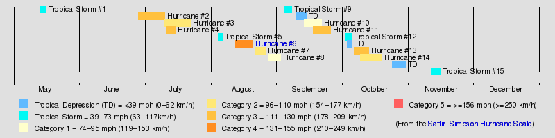
1916 was a fairly active season, especially for the time. Fifteen tropical cyclones formed during the course of the year. Ten hurricanes formed, and five of those were major hurricanes.
Tropical Storm One
| Tropical storm (SSHWS) |
|
|
| Duration |
May 13 – May 16 |
| Peak intensity |
45 mph (75 km/h) (1-min) 1004 mbar (hPa) |
On May 13, a tropical depression formed south of the Cuban coast. It quickly crossed the island and moved over the Straits of Florida. On May 14, it slowly strengthened to a minimal tropical storm, and it made landfall near Key Vaca, Florida with winds of 40 mph (65 km/h). It entered the Florida peninsula near Cape Sable, moving northward across the state. Gale force winds were reported east of the center. It transitioned to an extratropical cyclone on May 16. Initially, the cyclone was not included in the Atlantic hurricane database.[1]
Hurricane Two
| Category 3 hurricane (SSHWS) |
|
|
| Duration |
June 28 – July 10 |
| Peak intensity |
120 mph (195 km/h) (1-min) 950 mbar (hPa) |
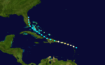
A tropical disturbance organized into a tropical storm on June 29 in the southwest Caribbean Sea. It moved to the north-northwest, brushing the coast of Honduras before strengthening into a hurricane on July 2. The hurricane continued to intensify, reaching major hurricane strength in the northern Gulf of Mexico on July 4. It made landfall near Gulfport, Mississippi with 120 mph (195 km/h) sustained winds on July 5. The damage was around $3 million with four deaths occurring. At the time, it was the earliest known major hurricane to make landfall in the U.S. in any season, but that record has since been broken by Hurricane Audrey.
In Florida, winds of 104 mph (167 km/h) was observed in Pensacola. People venturing outside were knocked down, while a few cars flipped over. Additionally, homes were unroofed, while chimneys and trees were toppled. At the aeronautic station, several hangars collapsed. Storm surge at Pensacola flooded an engine room at the municipal power plant, causing electrical outages. Further inland, heavy rainfall left severe crop damage in Florida, Alabama, Mississippi, and Tennessee. The storm left 34 deaths, 4 of which occurred in Florida, and #3 million in damage, including $1 million in Florida.
Hurricane Three
| Category 2 hurricane (SSHWS) |
|
|
| Duration |
July 10 – July 22 |
| Peak intensity |
105 mph (165 km/h) (1-min) 980 mbar (hPa) |
The third tropical storm was first observed east of the Lesser Antilles on July 10. It tracked northwestward, crossing the islands before reaching hurricane strength north of Puerto Rico on July 15. The hurricane continued to the northwest, and reached a peak of 105 mph (170 km/h) on July 16.[1] Cool and dry air weakened it to a 70 mph (110 km/h) tropical storm when it hit New Bedford, Massachusetts on July 21.[1] It caused little damage and no known deaths. Initially, the cyclone was recorded as a major hurricane, but it was subsequently downgraded by the Atlantic hurricane reanalysis project.
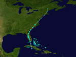
Hurricane Four
| Category 3 hurricane (SSHWS) |
|
|
| Duration |
July 11 – July 15 |
| Peak intensity |
115 mph (185 km/h) (1-min) 960 mbar (hPa) |
Hurricane Four, which developed on July 11 north of the Bahamas, reached a peak intensity of 115 mph (185 km/h) winds on July 13. The hurricane moved ashore near Charleston, South Carolina as a strong Category 2 hurricane on July 14.[1] Seven deaths were reported, with $100,000 in damage. The heavy rains from this storm caused severe flooding of the French Broad River at Asheville, North Carolina.[2] The rains caused more damage due to subsequent flooding in Gaston, Lincoln and Cleveland Counties and further into South Carolina with three textile mills and their neighboring villages being either damaged beyond repair or destroyed. Damages in North Carolina were estimated at $15–$20 million with the loss of 80 lives. Mountain Island Mill, the oldest operating textile mill in the state and the Mountain Island village was completely destroyed and swept away by the flood waters.[3]
Tropical Storm Five
| Tropical storm (SSHWS) |
|
|
| Duration |
August 4 – August 6 |
| Peak intensity |
60 mph (95 km/h) (1-min) <996 mbar (hPa) |
A tropical storm formed in the southern Gulf of Mexico on August 4. On August 5, it struck the Mexican state of Tamaulipas with estimated winds of 60 mph (95 km/h). Tropical storm force winds affected southern Texas.[1]
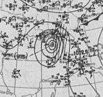
Hurricane Six
| Category 4 hurricane (SSHWS) |
|
|
| Duration |
August 12 – August 20 |
| Peak intensity |
135 mph (215 km/h) (1-min) 932 mbar (hPa) |
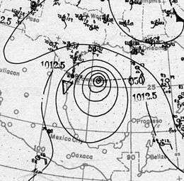
The fourth hurricane of the season was observed east of the Lesser Antilles on August 12. It passed through the islands, strengthening to a hurricane late on August 12 while crossing. On August 15, the hurricane hit Jamaica as a 90 mph (140 km/h) hurricane, and continued to the west-northwest through the Caribbean Sea and Yucatán Channel. On August 16, it became a major hurricane. It made landfall on Padre Island, Texas on August 18 as a 135 mph (215 km/h) hurricane. The hurricane caused 15 fatalities, with $1.8 million (1916 USD) in damage.
Hurricane Seven
| Category 2 hurricane (SSHWS) |
|
|
| Duration |
August 21 – August 26 |
| Peak intensity |
110 mph (175 km/h) (1-min) <997 mbar (hPa) |
The hurricane appeared over the northern Lesser Antilles on August 21. It tracked westward, becoming a hurricane and reaching a peak of 110 mph (175 km/h) winds before hitting Puerto Rico on August 22.[1] It was a small diameter hurricane that crossed Puerto Rico from Naguabo to Aguada.[4] From the Humacao region to the Aguadilla region suffered hurricane force winds, with minor damages in the east and north of Puerto Rico. One death occurred and the damages were estimated at $1 million (1916 USD, $20.9 million 2010 USD).[4] In San Juan winds were measured at 92 mph and the pressure was 29.82 inches.[4] The worst damages occurred in Santurse.
It crossed Hispaniola on August 23, weakened to a tropical storm, and paralleled the north coast of Cuba. This fast moving storm turned northward, passing west of Miami, Florida on August 25. It dissipated on August 26.[1]
Hurricane Eight
| Category 1 hurricane (SSHWS) |
|
|
| Duration |
August 27 – September 2 |
| Peak intensity |
80 mph (130 km/h) (1-min) 986 mbar (hPa) |
On August 27 a tropical storm was observed east of the Lesser Antilles. It strengthened into a hurricane that night before crossing Dominica with 80 mph (130 km/h) winds on August 28. This fast-moving hurricane moved through the Caribbean Sea, and it quickly weakened on August 30. On September 1 it made landfall on northern Belize as a tropical storm.[1] The hurricane caused moderate damage, taking an unknown number of lives.
Tropical Storm Nine
| Tropical storm (SSHWS) |
|
|
| Duration |
September 4 – September 7 |
| Peak intensity |
50 mph (85 km/h) (1-min) <1010 mbar (hPa) |
The ninth tropical storm of the season formed over the eastern Bahamas on September 4. It tracked northward, and hit near the North Carolina/South Carolina border on September 6.
Hurricane Ten
| Category 1 hurricane (SSHWS) |
|
|
| Duration |
September 13 – September 21 |
| Peak intensity |
85 mph (140 km/h) (1-min) <1000 mbar (hPa) |
The tenth tropical storm of the season, which was first observed on September 13 to the northeast of the Lesser Antilles, tracked westward before turning northward. It reached a peak of 85 mph (140 km/h) winds on September 18 before dissipating on September 24 in the northeast Atlantic.
Hurricane Eleven
| Category 3 hurricane (SSHWS) |
|
|
| Duration |
September 17 – September 24 |
| Peak intensity |
120 mph (195 km/h) (1-min) <975 mbar (hPa) |
On September 17 the eleventh tropical storm was seen east of Barbados. It headed west-northward, strengthening into a hurricane on September 19 before passing north of the Lesser Antilles. The hurricane reached a peak of 120 mph (195 km/h) winds on September 22. It passed by Bermuda on September 24, and became extratropical on the same day.[1]
Tropical Storm Twelve
| Tropical storm (SSHWS) |
|
|
| Duration |
October 2 – October 5 |
| Peak intensity |
60 mph (95 km/h) (1-min) 1000 mbar (hPa) |
A tropical storm formed on October 2 and struck the Georgia coast on October 4.[1]
Hurricane Thirteen
| Category 3 hurricane (SSHWS) |
|
|
| Duration |
October 6 – October 13 |
| Peak intensity |
120 mph (195 km/h) (1-min) 963 mbar (hPa) |
A tropical storm appeared near the Windward Islands on October 6. It headed northwestward then northward, reaching hurricane strength in the eastern Caribbean. It approached the equivalent of Category 2 intensity as it passed over Saint Croix.[1] While accelerating to the northeast, the hurricane reached major hurricane strength, but cooler waters caused it to become extratropical on October 15.
Hurricane Fourteen
| Category 2 hurricane (SSHWS) |
|
|
| Duration |
October 9 – October 19 |
| Peak intensity |
110 mph (175 km/h) (1-min) 970 mbar (hPa) |
A tropical depression organized to a tropical storm on October 11 in the western Caribbean. It moved westward, reaching hurricane strength on the 13th before hitting the Yucatán Peninsula on the 15th as a 110 mph (175 km/h) hurricane. It weakened over land, and it emerged over the southern Gulf of Mexico as a tropical storm. It quickly re-strengthened to a strong Category 2 hurricane, hitting Pensacola on October 18.[1] This storm was a fast moving one so the damage was limited, but a ship sank offshore, killing 20 people.
Tropical Storm Fifteen
| Tropical storm (SSHWS) |
|
|
| Duration |
November 11 – November 15 |
| Peak intensity |
70 mph (110 km/h) (1-min) 1002 mbar (hPa) |
The last storm of the season was first seen on November 11 in the Caribbean Sea. It tracked west-northwestward, hitting Honduras on the 13th. The storm turned northward, reaching peak winds of 70 mph (110 km/h) over the Yucatán Channel on November 14. It transitioned to an extratropical cyclone on November 15, and it passed over Key West.[1]
See also
References
- 1 2 3 4 5 6 7 8 9 10 11 12 13 Hurricane Research Division. "HURDAT Meta-Data". NOAA. Archived from the original on 16 March 2008. Retrieved February 15, 2008.
- ↑ Western North Carolina Heritage. ASHEVILLE FLOOD of 1916. Retrieved on June 23, 2008.
- ↑ Ragan, Robert (2001). The textile heritage of Gaston County, North Carolina, 1848-2000: one hundred mills and the men who built them. Charlotte, NC: Loftin & Company Printers, inc. p. 18. OCLC 51090391.
- 1 2 3 Mújica-Baker, Frank. Huracanes y Tormentas que han afectado a Puerto Rico (PDF). Estado Libre Asociado de Puerto Rico, Agencia Estatal para el manejo de Emergencias y Administración de Desastres. p. 11. Retrieved August 30, 2010.
External links