1942 Atlantic hurricane season
| |
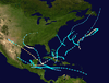
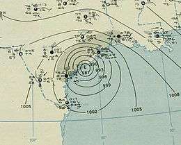
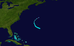
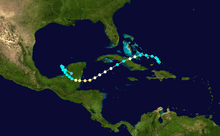
| Season summary map |
| First system formed |
August 3, 1942 |
| Last system dissipated |
November 11, 1942 |
| Strongest storm1 |
Three – 950 mbar (hPa) (28.05 inHg), 115 mph (185 km/h) (1-minute sustained) |
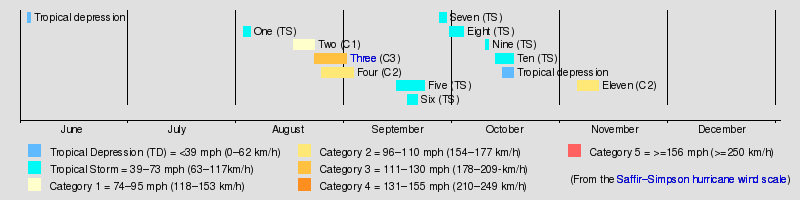
| Total depressions |
13 |
| Total storms |
11 |
| Hurricanes |
4 |
| Major hurricanes (Cat. 3+) |
1 |
| Total fatalities |
17 |
| Total damage |
$30.6 million (1942 USD) |
| 1Strongest storm is determined by lowest pressure |
Atlantic hurricane seasons
1940, 1941, 1942, 1943, 1944 |
The 1942 Atlantic hurricane season officially began on June 16, 1942, and lasted until October 31, 1942.[1] These dates conventionally delimit the period of each year when most tropical cyclones form in the Atlantic basin.
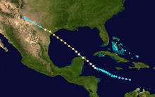
The 1942 season was near average. A few storms of note were two Category 1 storms striking north and central Texas and a Category 2 hitting Belize. Most of the rest of the season's storms stayed out to sea. Only 1 major hurricane formed during the season and the only other landfall was a weak tropical storm that struck the Outer Banks as a tropical depression.
Storms
Tropical Storm One
| Tropical storm (SSHWS) |
|
|
| Duration |
August 3 – August 5 |
| Peak intensity |
60 mph (95 km/h) (1-min) 1004 mbar (hPa) |
On August 1, a low-pressure area was first detected in the vicinity of Puerto Cabezas, Nicaragua. However, data at the time was not conclusively indicative of a tropical cyclone. The tropical low was later analyzed to have sufficiently organized to be classified as a tropical depression by 0000 UTC on August 3, as it moved westward in the Gulf of Honduras.[2][3] Six hours later, the depression was estimated to have intensified into a tropical storm based on barometric readings from Tela, Honduras and Belize City.[2][3] Shortly after, the tropical storm made its first landfall on British Honduras with maximum sustained winds of 40 mph (65 km/h). The tropical cyclone weakened to tropical depression intensity during its trek over the Yucatán Peninsula before emerging into the Bay of Campeche on August 4.[2] Over water, the storm was able to reintensify further and attained a peak intensity at 0600 UTC the following day with winds of 50 mph (80 km/h).[3] Three hours later, the storm made its final landfall south of Tampico, Mexico at the same intensity,[2] before weakening over the mountainous terrain of Mexico and dissipating late on August 5.[3]
Upon landfall near Tampico, a station in the city recorded a minimum barometric pressure of 1,004 mbar (hPa; 29.65 inHg), the lowest pressure measured in association with the storm. A lack of available weather ships in the region due to World War II, no ships documented the tropical cyclone. In Texas, the tropical cyclone caused light rainfall, damaging local cotton crops, and strong gusts in the Rio Grande Valley.[2]
Hurricane Two
| Category 1 hurricane (SSHWS) |
|
|
| Duration |
August 17 – August 23 |
| Peak intensity |
80 mph (130 km/h) (1-min) 992 mbar (hPa) |
A tropical storm was first observed on August 17 near the Yucatán Peninsula. It tracked northwestward, where it slowly intensified to a minimal hurricane. The hurricane made landfall on the eastern Texas coast on August 21 at Crystal Beach near the entrance to Galveston Bay, and dissipated two days later over extreme southern Missouri. The hurricane caused around $600,000 in damage.
Hurricane Three
| Category 3 hurricane (SSHWS) |
|
|
| Duration |
August 23 – September 1 |
| Peak intensity |
115 mph (185 km/h) (1-min) 950 mbar (hPa) |
The precursor to Hurricane Two, a tropical wave, developed into a tropical storm on August 21 over the Windward Islands. This tropical storm moved westward over the Caribbean Sea, strengthening to a hurricane on August 25 south of Jamaica. The hurricane crossed over the northeast tip of the Yucatán Peninsula on August 28. While over the Gulf of Mexico, the hurricane peaked with winds of 100 knots (190 km/h; 120 mph); it made landfall near Palacios, Texas, as an intense hurricane.[4]
The next day it dissipated over northwestern Texas, after resulting in $26.5 million in damage and eight casualties. The dissipating tropical storm brought extensive heavy rain well into New Mexico. River floods resulted downstream in Oklahoma in early September.
Hurricane Four
| Category 2 hurricane (SSHWS) |
|
|
| Duration |
August 25 – September 3 |
| Peak intensity |
110 mph (175 km/h) (1-min) |
The third storm of the season was first detected as a minimal hurricane southeast of Bermuda on August 25 heading northwest. It is possible it started earlier, perhaps a Cape Verde-type hurricane, but observations were minimal at best due to the lack of ships during World War II. It passed Bermuda to the east, strengthening to a Category 2 storm as it did so, recurving to the northeast. It continued to gain intensity and peaked just below major hurricane status with winds of 110 mph (180 km/h). It weakened as it reached cooler waters, dropping below hurricane strength at 39N latitude and looping back south and then west before dissipating on September 2.
Tropical Storm Five
| Tropical storm (SSHWS) |
|
|
| Duration |
September 15 – September 23 |
| Peak intensity |
50 mph (85 km/h) (1-min) 1002 mbar (hPa) |
A Caribbean storm, Storm Four formed roughly 100 miles (160 km) northeast of Barbados in mid September and moved on a steady west-northwest track, not strengthening much. Its winds never rose above 50 mph (80 km/h). Storm Four turned more to the west after it passed south of Jamaica and struck northern Belize as a weakening tropical storm. It dissipated shortly thereafter.
Tropical Storm Six
| Tropical storm (SSHWS) |
|
|
| Duration |
September 18 – September 21 |
| Peak intensity |
50 mph (85 km/h) (1-min) 1000 mbar (hPa) |
The fifth storm of the season was short-lived. It formed not far southwest of Bermuda on September 18 and moved generally northward for the next four days. Its winds peaked at 50 mph (80 km/h) before becoming extratropical on September 22.
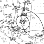
Tropical Storm Seven
| Tropical storm (SSHWS) |
|
|
| Duration |
September 27 – September 29 |
| Peak intensity |
50 mph (85 km/h) (1-min) 1010 mbar (hPa) |
Another weak Bermuda storm, Storm Six formed several hundred miles southeast of that island in late September and ended up making a horseshoe-like track around it, never coming within 100 miles (160 km) and passing to Bermuda's west. Winds topped out at 50 mph (80 km/h). It dissipated some 300 miles (480 km) north of the island in cooler waters on September 30.
Tropical Storm Eight
| Tropical storm (SSHWS) |
|
|
| Duration |
September 30 – October 4 |
| Peak intensity |
70 mph (110 km/h) (1-min) 996 mbar (hPa) |
Storm Seven formed near the Turks and Caicos Islands on the first day of October and headed due northeast for almost its entire lifespan. It passed just to the southeast of Bermuda (an oft-visited island this season) and reached its peak intensity of 70 mph (110 km/h) shortly thereafter. In fact, it may have become a hurricane during the post-tropical transition stage but sparse data precluded such an upgrade. It became fully extratropical on October 4 as it approached 40N.
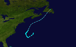
Tropical Storm Nine
| Tropical storm (SSHWS) |
|
|
| Duration |
October 10 – October 11 |
| Peak intensity |
45 mph (75 km/h) (1-min) 1002 mbar (hPa) |
The season's eighth storm was a very weak system that formed in the open waters of the Sargasso Sea several hundred miles west-southwest of Bermuda on October 10. It curved gently west-northwestward and then northwestward toward the North Carolina's Outer Banks, making landfall near Cape Lookout shortly after becoming post-tropical two days following formation. It dissipated later that day. Eastern North Carolina suffered heavy rainfall.
Tropical Storm Ten
| Tropical storm (SSHWS) |
|
|
| Duration |
October 13 – October 18 |
| Peak intensity |
50 mph (85 km/h) (1-min) 1005 mbar (hPa) |
Storm Nine formed near Jamaica on October 13 and moved due north through southern Cuba and the Bahamas before shifting to the northeast for the remainder of its lifetime, parallelling the eastern seaboard of the United States but remaining well offshore. It lost its identity near Sable Island, Nova Scotia. No damaging effects were reported from any of the affected islands.
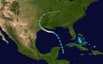
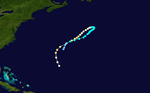
Hurricane Eleven
| Category 2 hurricane (SSHWS) |
|
|
| Duration |
November 5 – November 11 |
| Peak intensity |
110 mph (175 km/h) (1-min) 992 mbar (hPa) |
On November 5, a tropical storm was first seen over the northern Lesser Antilles. It headed west-northwestward, becoming a hurricane on November 6 over the southern Bahamas. A ridge of high pressure to its north forced the storm west-southwestward, where it hit Cuba later that day. After weakening over the island, the now tropical storm re-strengthened to a hurricane on November 8 over the western Caribbean Sea. It attained a peak of at least 110 mph (180 km/h) winds before hitting Belize on November 9, which is a conservative assessment as it is possible the storm strengthened into a major hurricane but there was no conclusive data. After crossing the Yucatán Peninsula, the ridge of high pressure built to its northwest, forcing the storm back southeastward. It hit the western Yucatán Peninsula on November 11, and dissipated shortly thereafter over land. The hurricane was responsible for nine deaths, $4 million in damage, and unavailable damage figures elsewhere. It has been detected in sediment cores from the bottom of the Great Blue Hole.[5]
See also
References
- ↑ Port Arthur News. Weather Bureau Goes On 24-Hour Schedule For 'Hurricane Season. Retrieved on 2008-06-06.
- 1 2 3 4 5 Landsea, Chris; Atlantic Oceanic Meteorological Laborartory; et al. (June 2013). "Documentation of Atlantic Tropical Cyclones Changes in HURDAT". United States National Oceanic and Atmospheric Administration. Archived from the original on 2 August 2013. Retrieved 9 July 2013.
- 1 2 3 4 National Hurricane Center; Hurricane Research Division (July 6, 2016). "Atlantic hurricane best track (HURDAT version 2)". United States National Oceanic and Atmospheric Administration. Retrieved December 5, 2016.
- ↑ Blake; Rappaport & Landsea (2006). "The Deadliest, Costliest, and Most Intense United States Tropical Cyclones (1851 to 2006)" (PDF). NOAA. Archived (PDF) from the original on 1 July 2007. Retrieved 2007-06-08.
- ↑ Gischler, Eberhard; Shinn, Eugene A.; Oschmann, Wolfgang; Fiebig, Jens; Buster, Noreen A. (2008), "A 1500-Year Holocene Caribbean Climate Archive from the Blue Hole, Lighthouse Reef, Belize", Journal of Coastal Research, 24 (6): 1495–1505, doi:10.2112/07-0891.1
External links
|
|---|
|
| |
|
-
 Book Book
-
 Category Category
-
 Portal Portal
-
 WikiProject WikiProject
-
 Commons Commons
|