2009 North American Christmas blizzard
| Category 5 "Extreme" (RSI: 18.67) | |
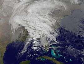 Satellite image of the storm on Christmas Eve. | |
| Type |
Extratropical cyclone Blizzard Winter storm |
|---|---|
| Formed | December 22, 2009 |
| Dissipated | December 28, 2009 |
| Lowest pressure | 985 millibars (985 hPa)[1] |
| Maximum snowfall or ice accretion | 40.0 inches (102 cm) (Lead, South Dakota)[1] |
| Areas affected | Midwest, Great Plains, Parts of Ontario, Eastern Seaboard |
| Part of the 2009–10 North American winter | |
The 2009 North American Christmas blizzard was powerful winter storm and severe weather event that affected the Midwestern United States, Great Plains, Southeastern United States, the Eastern Seaboard, and parts of Ontario. The storm started on December 22, was reported to have claimed at least 21 lives, and disrupted air travel during the Christmas travel season.[2] In the Southeastern and Central United States, there were 27 reported tornadoes on December 23–24.[3][4] The storm, a Category 5 "Extreme" one on the Regional Snowfall Index, was the first winter weather event to rank as such since the Blizzard of '96.
Impact
Snowfall
Snowfall varied across the United States. South Dakota may have received the most: 30.8 inches (78 cm).[1] In Minnesota, 26 inches (66 cm) was received near Pequaywan Lake on the state's North Shore.[5] Parts of Texas recorded snowfall as high as 9 inches (23 cm) at Post.[1] Snowfall in Nebraska caused six deaths.[6] In Oklahoma, a state of emergency was declared after blizzard conditions killed 3 people and dropped 19 inches of snow.[6] Iowa saw high snowfall as well.[7]
The storm was so intense that it wrapped warm air around the north and west side of it and cold air and snow blew in from the south. Rochester, Minnesota, in the northern half of the storm, saw rain with temperatures in the mid 30's Fahrenheit while snow was falling just to the west in a 1,300-mile (2,100 km) band stretching from Canada south to at least Dallas, Texas, giving that region its first "White Christmas" since 1929.[8] Interstate 29 was completely closed in North and South Dakota, and then in stretches into Missouri.[9][10]
Rain
Heavy rain in parts of the Midwest prompted the National Weather Service to issue Flood Warnings for many areas. The max rainfall amount recorded so far is 6.89 inches (17.5 cm) in Little Rock, Arkansas.[1] Freezing rain fell across Iowa and Illinois, affecting travel to and from O'Hare International Airport.[1] The Chicago area saw as much as ten inches of snow following the freezing rain and sleet.[11]
Tornadoes
Several houses were destroyed near Lafayette, Louisiana, possibly by a tornado.[12] Near Longview, Texas a EF-2 tornado left a path of destruction nearly one mile long.[13] Another tornado near Lufkin, Texas produced EF-3 damage.[14]
Confirmed tornadoes
| EF0 | EF1 | EF2 | EF3 | EF4 | EF5 | Total |
|---|---|---|---|---|---|---|
| 8 | 4 | 2 | 1 | 0 | 0 | 15 |
| List of reported tornadoes – Wednesday, December 22, 2009 | ||||||
|---|---|---|---|---|---|---|
| | | | | | ||
| Louisiana | ||||||
| EF0 | S of Martin | Red River | 2.76 miles (4.44 km) | |||
| EF0 | S of Pleasant Hill | Sabine | 1.2 miles (1.9 km) | |||
| EF0 | N of Many | Sabine | 2.6 miles (4.2 km) | |||
| EF1 | W of Farmerville | Union | 6 miles (9.7 km) | |||
| Texas | ||||||
| EF0 | W of Pineland | Sabine | 1.5 miles (2.4 km) | |||
| EF0 | W of Fairmont | Sabine | 0.5 miles (0.80 km) | |||
| EF0 | Recklaw area | Rusk | 0.1 miles (0.16 km) | |||
| EF2 | Longview area | Harrison | 7 miles (11 km) | |||
| EF3 | Lufkin area | Angelina | 4 miles (6.4 km) | |||
| EF0 | Jacksonville area | Cherokee | 2 miles (3.2 km) | |||
| EF0 | NE of New Summerfield | Cherokee | 3 miles (4.8 km) | |||
| EF1 | SE of Atlanta area | Cass, Miller (AR) | 4 miles (6.4 km) | |||
| EF1 | S of Avinger | Cass | 0.1 miles (0.16 km) | |||
| EF2 | Timpson area | Shelby, Panola | 10 miles (16 km) | |||
| EF1 | Garrison area | Nacogdoches | 0.5 miles (0.80 km) | |||
See also
- Winter storms of 2009–10
- North American blizzard of 2009
- February 2009 Great Britain and Ireland snowfall
- East Asian snowstorms of 2009-2010
- East Asian snowstorms of late 2009
- December 2009 North American snowstorms
References
- 1 2 3 4 5 6 "Storm Summary Number 06 For Christmas 2009 Blizzard". HPC. December 24, 2009. Archived from the original on December 9, 2009. Retrieved December 25, 2009.
- ↑ "Deadly winter storm arrives in US Midwest". BBC News. December 24, 2009. Archived from the original on December 25, 2009. Retrieved December 24, 2009.
- ↑ "091223's Storm Report (1200 UTC – 1159 UTC)". Storm Prediction Center. December 23, 2009. Archived from the original on January 15, 2010. Retrieved December 25, 2009.
- ↑ "Today's Storm Reports (1200 UTC – 1159 UTC)". Storm Prediction Center. December 24, 2009. Archived from the original on December 28, 2009. Retrieved December 25, 2009.
- ↑ "Archived copy". Archived from the original on June 25, 2010. Retrieved 2009-12-28.
- 1 2 "U.S. storm turns deadly before Christmas". United Press International (UPI). Retrieved December 25, 2009.
- ↑ "Iowa Environmental Mesonet". Iowa State University. December 24, 2009. Retrieved December 25, 2009.
- ↑ "White Christmas Across South Central US". NASA MODIS Website. December 29, 2009. Retrieved January 8, 2010.
- ↑ Liz Robbins (December 25, 2009). "Huge Storm Hobbles Middle of Nation". New York Times. Retrieved January 8, 2010.
- ↑ "White Out Christmas, Best To Stay In". WOWT. December 25, 2009. Retrieved January 8, 2010.
- ↑ Another 1 to 3 inches of snow expected, Chicago Sun Times, December 27, 2009
- ↑ "1 Death Blamed on Storms in Louisiana". New York Times. Associated Press. December 24, 2009. Retrieved December 25, 2009.
- ↑ Demarest, Janis. "Aerial tour of tornado damaged areas". KLTV. Associated Press. Retrieved December 25, 2009.
- ↑ Parker, Bill. "Public Information Statement, NWS Shreveport". Retrieved December 25, 2009.