2010 Zambian census
The 2010 Zambian census was conducted in Zambia in 2010 under the approval of the Government of Zambia, which recorded demographic data from 13 million people and 3.2 million households. The 2010 Census of Population and Housing was conducted between 16 October and 15 November 2010, with all parts of the country covered by 30 November 2010. It was the fifth national population census exercise of Zambia since its independence in 1964, with the previous censuses conducted in 1969, 1980, 1990 and 2000. A total of 3.2 million questionnaires were used for data collection and the processing started in April 2011 by the Central Statistical Office. Optical Mark Reading (OMR) and Intelligent Character Recognition (ICR) technology were used for data capture.
The census was funded by United Nations Population Fund (UNFPA), the United Kingdom AID (UKAID-formerly DFID), the United States Agency for International Development (USAID) and the African Development Bank (AfDB), who contributed close to 60 per cent of the total expenditure and rest contributed by the Ministry of Finance of the Government of Zambia.
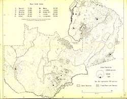
As per the census, Zambia had a total population of 13,092,666 including 6,454,647 males and 6,638,019 females. The inter-decadal growth was 2.8 per cent compared to 2.5 per cent during the census of 2000. As per the census, Lusaka was the most populated and most densely populated province with a population of 2,191,225 and density of 100 persons per km2. As of 2010, Western Province had the best sex ratio of 108 females for every 100 males, while Copperbelt had the lowest of 101. Northern had the highest number of basic schools, while Copperbelt had the highest number of high schools. The unemployment rate of youth (55%) and general unemployment rate (32%) was the highest in Copperbelt province, while Eastern had the lowest unemployment rate of 6 per cent. AIDS death was maximum in Copperbelt with 26,799 recorded deaths in 2010, while it was lowest in North-Western with 2,859 recorded deaths.
A Post Enumeration Survey (PES) was carried out to find the common issues to be considered into account for future census enumeration activities. The results of the PES indicated that 92.7 per cent of total Zambian residents were captured in the 2010 census, leaving an undercount of 7.3 per cent. The undercount was more in rural areas with an estimated 9.5 per cent of the total population and 3.8 per cent in the urban areas.
Background
From independence, four census enumeration exercises were carried out during the years of 1969, 1980, 1990 and 2000. The 2010 census was funded by United Nations Population Fund (UNFPA), the United Kingdom AID (UKAID-formerly DFID), the United States Agency for International Development (USAID) and the African Development Bank (AfDB), who contributed close to 60 per cent of the total expenditure, with the rest contributed by the Ministry of Finance of the Government of Zambia.[1] As a part of Department for International Development (DFID) funding, the 2010 Zambian census was allocted LBP 3 million during the period of 2010-13 for financial and technical support by the government of United Kingdom.[2]
The second GDDS2 expert mission (a wing of World Bank) on Population of Zambia took place during 23 – 27 February 2009 and it published a report with recommendations before the survey. The report suggested using satellite imagery software, having frequent meetings with census steering committees, utilizing time-tested OMR process for transferring data from census forms to computer-readable files or newer methods like OCR, assuring the quality of printing of the census questionnaires, taking Post-enumeration Survey (PES) on time, providing staff training for more in-depth census analysis, changing the population growth rate reporting structure, including measures from the 2007 Demographic and Health Survey (DHS), publish a census publication for a general audience, obtaining technical assistance for post-census population projections at the national, province and district level, reprojection of HIV prevalence, mortality, and AIDS orphanhood and establishing a long-term MOU with a technical assistance organization, such as the U.S. Census Bureau.[3]
Administration
Zambian 2010 census was carried out from 16 October to 15 November 2010 by 25,000 school leavers deputed by the Census Statistical Office of Zambia along with 8,400 census supervisors. Civil servants from various Government departments trained the enumerators. There were two forms, namely Form A, which had basic details of full name, sex, membership status and was expected to be answered by senior member of each household. Form B had details about individual members of the family. When the respondent was a minor, proxy members having knowledge about the family were enquired. The details in form B were not sufficiently captured on account of knowledge of family members from the proxy members. All buildings that were complete, incomplete, abandoned, habitable or inhabitable were accounted by the enumerators. Compared to the form of 2000, there were additional details on deaths of household members, maternal deaths, albimism, orphanhood and fosterhood were obtained.[4] The enumeration completed by 15 November 2010 for majority of the regions, with all parts of the country getting completed by 30 November 2010. A total of 3.2 million questionnaires were used for data collection and the processing started in April 2011 by the Central Statistical Office. OMR and ICR technology were used for data capture.[1]
Release

The census report of 2010 was released during the first week of March 2013 by Fredson Yamba, Secretary to the Treasury of the Government of Zambia. He quoted that “Population is our most valuable resource and we can only take stock of it through an activity like the census. We now have the data, therefore, the challenge remains with all of us to ensure it is put into good use by making informed decisions for our people,”.[5] UNICEF helped the Government of Zambia, especially the Child Welfare Ministry to update the data from the census Living Condition Monitoring Survey (LCMS) and data on all key performance indicators of the National Development Plan (ZNDP) during 2013.[6]
The Government of Zambia also initiated the Central Statistics Office to review the census of 2010 to see if it can be used to determine the eligible voters for the proposed referendum in 2016.[7]
Reports
Zambia had a total population of 13,092,666 including 6,454,647 males and 6,638,019 females. Among the provinces, Lusaka had the largest population followed by Copperbelt, Eastern, Southern and Central. The interdecadal growth was 2.8 per cent compared to 2.5 per cent during the census of 2000.[8]
| Provinces | Rank | Population | % of total population | Males | Females | Sex Ratio | Literacy rate (%)[9] | Rural Population (%)[10] |
Urban Population (%) |
Area (km²) |
Density (/km²)[11] |
Decadal Growth (%) (2000-2010) |
|---|---|---|---|---|---|---|---|---|---|---|---|---|
| Central | 5 | 1,307,111 | 10.05 | 648,465 | 658,646 | 1,016 | 70.90 | 74.87 | 25.13 | 94,394 | 13.8 | 2.60 |
| Copperbelt | 2 | 1,972,317 | 15.21 | 981,887 | 990,430 | 1,009 | 83.10 | 19.11 | 80.89 | 31,328 | 63 | 2.20 |
| Eastern | 3 | 1,592,661 | 12.16 | 784,680 | 807,981 | 1,030 | 54.40 | 87.42 | 12.58 | 51,476 | 30.9 | 2.60 |
| Luapula | 7 | 991,927 | 7.57 | 488,589 | 503,338 | 1,030 | 62.60 | 80.39 | 19.61 | 50,567 | 19.6 | 2.50 |
| Lusaka | 1 | 2,191,225 | 16.78 | 1,082,998 | 1,108,227 | 1,023 | 83.00 | 15.35 | 84.65 | 21,896 | 100.1 | 4.60 |
| Muchinga | 9 | 711,657 | 5.42 | 349,872 | 361,785 | 1,034 | 63.50 | 82.99 | 17.01 | 87,806 | 8.1 | 3.10 |
| Northern | 6 | 1,105,824 | 8.47 | 546,851 | 558,973 | 1,022 | 61.00 | 81.68 | 18.32 | 77,650 | 14.2 | 3.20 |
| North-Western | 8 | 727,044 | 5.55 | 358,141 | 368,903 | 1,030 | 63.00 | 77.45 | 22.55 | 125,826 | 5.8 | 2.20 |
| Southern | 4 | 1,589,926 | 12.08 | 779,659 | 810,267 | 1,039 | 71.20 | 75.33 | 24.67 | 85,283 | 18.6 | 2.80 |
| Western | 8 | 902,974 | 6.72 | 433,505 | 469,469 | 1,083 | 61.60 | 86.73 | 13.27 | 126,386 | 7.1 | 1.70 |
| TOTAL | Zambia | 13,092,666 | 100 | 6,454,647 | 6,638,019 | 1,028 | 70.2 | 60.49 | 39.51 | 752,612 | 17.4 | 2.8 |
| Provinces | 2010 Population | 2010 rank | 2000 Population | 2000 | 1990 | 1980 | 1969 | 1964 |
|---|---|---|---|---|---|---|---|---|
| Central | 1,307,111 | 5 | 1,012,257 | 6 | 983,914 | 942,589 | 713,000 | 505,000 |
| Copperbelt | 1,972,317 | 2 | 1,581,221 | 1 | 1,568,571 | 1,545,043 | 816,000 | 544,000 |
| Eastern | 1,592,661 | 3 | 1,306,173 | 3 | 953,506 | 911,552 | 510,000 | 480,000 |
| Luapula | 991,927 | 7 | 775,353 | 7 | 750,542 | 728,776 | 336,000 | 357,000 |
| Lusaka | 2,191,225 | 1 | 1,391,329 | 2 | 1,342,632 | 1,292,955 | - | - |
| Muchinga Province | 711,657 | 10 | - | - | - | - | - | - |
| Northern | 1,105,824 | 6 | 1,258,696 | 4 | 1,219,676 | 1,180,647 | 545,000 | 564,000 |
| North-Western | 727,044 | 9 | 583,350 | 9 | 566,433 | 544,908 | 232,000 | 211,000 |
| Southern | 1,589,926 | 4 | 1,212,124 | 5 | 1,178,185 | 1,134,592 | 496,000 | 466,000 |
| Western | 902,974 | 8 | 765,088 | 8 | 751,316 | 730,280 | 410,000 | 363,000 |
| Zambia | 13,092,666 | 9,885,591 | 9,638,451 | 9,339,659 | 4,057,000 | 3,490,000 |
Western Province was the largest among all provinces, having 126,386 km2, while Lusaka was the smallest with 21,896 km2.[13] In terms of population, Lusaka was the most populated and most densely populated with a population of 2,191,225 and density of 100 persons per km2.[14] As of 2010, Western Province had the best sex ratio of 108 females for every 100 males,[15] while Copperbelt had the lowest of 101.[16] Northern had the highest number of basic schools,[17] while Copperbelt had the highest number of high schools.[16] The unemployment rate of youth (55%) and general unemployment rate (32%) was the highest in Copperbelt province,[16] while Eastern had the lowest unemployment rate of 6 per cent. AIDS death was maximum in Copperbelt with 26,799 recorded deaths in 2010,[16] while it was lowest in North-Western with 2,859 recorded deaths.[18] Lusaka Province had the most number of doctors and least number of Malaria related incidents, while North-Western had the lowest number of doctors.[18]
| Parameter | Year | Central[19] | Copperbelt[16] | Eastern[15] | Luapula[20] | Lusaka[14] | Muchinga Province[21] | Northern[17] | North-Western[18] | Southern[22] | Western[13] |
|---|---|---|---|---|---|---|---|---|---|---|---|
| Capital | 000 | Kabwe | Ndola | Chipata | Mansa | Lusaka | Chinsali | Kasama | Solwezi | Livingstone | Mongu |
| Land area, km2 | 000 | 94,394 | 31,328 | 51,476 | 50,567 | 21,896 | 87,806 | 77,650 | 125,826 | 85,283 | 126,386 |
| Population, persons | 2010 | 1,307,111 | 1,972,317 | 1,592,661 | 991,927 | 2,191,225 | 711,657 | 1,105,824 | 727,044 | 1,589,926 | 902,974 |
| Population density, people per km2 | 2010 | 014 | 063 | 031 | 020 | 100 | 008 | 014 | 006 | 019 | 007 |
| Sex Ratio (females per 100 males) | 2010 | 102 | 101 | 103 | 103 | 102 | 103 | 102 | 103 | 104 | 108 |
| Unemployment rate (%) | 2010 | 12.7 | 22.1 | 8.8 | 7.7 | 20.0 | 6.4 | 6.3 | 10.3 | 12.1 | 7.7 |
| AIDS Deaths | 2010 | 9,016 | 26,799 | 9,338 | 5,209 | 15,429 | No data | 6,958 | 2,859 | 12,403 | 6,044 |
Language and ethnicity
Christianity is the official religion in Zambia according to the 1996 constitution.[23] Christians belonging to various denominations formed a majority, while many other religious traditions were also present. In 2010, according to World Christian Trends, 85.5 per cent of the population identified as Christian, 11.2 per cent identified with indigenous religions, 1.8 per cent identified as Bahá'í, 1.1 per cent identified as Muslim, 0.2 per cent identified as agnostic, 0.1 per cent identified as Hindu, and all other groups accounted for less than 0.1 per cent.[24] The 2010 Zambian census found that 75.3 per cent of Zambians were Protestant, 20.2 per cent were Catholic, 0.5 per cent were Muslim, 2.0 per cent followed other religions, and 1.8 per cent had no religion.[25]
Bemba was the most widely spoken language in both urban and rural Zambia with a total of 33.5 per cent speaking it, followed by Nyanja spoken by 14.8 per cent population. At a national level, Toka-Leya remained the least spoken language with 0.5 per cent, but English remained the least spoken language in rural areas with only 0.2 per cent using it.[26]
| Language | Total (%) | Rural (%) | Urban (%) |
|---|---|---|---|
| Bemba | 33.5 | 22.5 | 49.5 |
| Lala | 1.8 | 2.9 | 0.3 |
| Bisa | 1 | 1.6 | 0.1 |
| Ushi | 0.9 | 1.4 | 0.2 |
| Lamba | 1.8 | 2.7 | 0.4 |
| Tonga | 11.4 | 15.9 | 4.9 |
| Lenje | 1.2 | 1.8 | 0.2 |
| Ila | 0.7 | 1.1 | 0.2 |
| Toka-Leya | 0.5 | 0.8 | 0.1 |
| Luvale | 1.5 | 2 | 0.9 |
| Lunda(North Western | 1.9 | 2.6 | 0.9 |
| Mbunda | 0.7 | 1.1 | 0.2 |
| Kaonde | 1.9 | 2.4 | 1.1 |
| Lozi | 5.5 | 7.1 | 3.2 |
| Chewa | 4.5 | 6.8 | 1.2 |
| Nsenga | 3 | 4.3 | 1 |
| Ngoni | 0.7 | 0.9 | 0.4 |
| Nyanja | 14.8 | 5.7 | 28 |
| Tumbuka | 2.6 | 4 | 0.5 |
| Senga | 0.7 | 1.1 | 0.1 |
| Lungu | 0.6 | 0.8 | 0.3 |
| Mambwe | 1.3 | 1.8 | 0.5 |
| Namwanga | 1.2 | 1.6 | 0.7 |
| English | 1.7 | 0.2 | 3.8 |
According to the census of 2010, Bemba was the most populous tribal community forming 21 per cent of the total population, following Tonga, who formed 13.6 per cent of the total population. Chokwe were the smallest community with 0.5 per cent of toal population. In rural areas, Tonga was the major community with 16.8 per cent while in urban areas it was Bemba, who formed 28.5 per cent.[27]
| Ethnicity | Total | Male (%) | Female (%) | Rural (%) | Rural male (%) | Rural female (%) | Urban (%) | Urban male (%) | Urban female (%) |
|---|---|---|---|---|---|---|---|---|---|
| Bemba | 21.0 | 21.0 | 21.0 | 16.0 | 16.0 | 15.9 | 28.5 | 28.4 | 28.6 |
| Lunda (Luapula) | 0.9 | 1.0 | 0.9 | 0.7 | 0.7 | 0.7 | 1.3 | 1.3 | 1.2 |
| Lala | 3.1 | 3.1 | 3.1 | 3.4 | 3.4 | 3.3 | 2.8 | 2.7 | 2.8 |
| Bisa | 1.6 | 1.5 | 1.6 | 2.0 | 1.9 | 2.0 | 1.0 | 1.0 | 1.0 |
| Ushi | 1.9 | 1.9 | 1.9 | 1.9 | 1.9 | 1.9 | 1.8 | 1.8 | 1.8 |
| Chishinga | 0.5 | 0.5 | 0.5 | 0.6 | 0.6 | 0.6 | 0.3 | 0.3 | 0.3 |
| Ngumbo | 0.6 | 0.6 | 0.7 | 0.9 | 0.8 | 0.9 | 0.3 | 0.3 | 0.3 |
| Lamba | 2.1 | 2.0 | 2.1 | 2.2 | 2.2 | 2.2 | 1.9 | 1.9 | 1.9 |
| Tabwa | 0.7 | 0.7 | 0.7 | 1.0 | 1.0 | 1.0 | 0.3 | 0.3 | 0.3 |
| Tonga | 13.6 | 13.5 | 13.6 | 16.8 | 16.8 | 16.8 | 8.7 | 8.6 | 8.9 |
| Lenje | 1.6 | 1.6 | 1.6 | 1.7 | 1.7 | 1.7 | 1.4 | 1.3 | 1.4 |
| Soli | 0.7 | 0.7 | 0.7 | 0.7 | 0.7 | 0.7 | 0.8 | 0.8 | 0.8 |
| Ila | 0.8 | 0.8 | 0.8 | 0.9 | 0.9 | 0.9 | 0.6 | 0.6 | 0.6 |
| Luvale | 2.2 | 2.2 | 2.2 | 2.1 | 2.2 | 2.1 | 2.2 | 2.3 | 2.2 |
| Lunda (North Western) | 2.6 | 2.6 | 2.6 | 2.9 | 2.9 | 2.9 | 2.2 | 2.2 | 2.1 |
| Mbunda | 1.2 | 1.2 | 1.2 | 1.6 | 1.6 | 1.7 | 0.6 | 0.6 | 0.6 |
| Chokwe | 0.5 | 0.5 | 0.5 | 0.5 | 0.5 | 0.5 | 0.5 | 0.5 | 0.5 |
| Kaonde | 2.9 | 2.9 | 2.9 | 2.8 | 2.8 | 2.8 | 3.2 | 3.2 | 3.1 |
| Lozi | 5.7 | 5.7 | 5.8 | 6.1 | 6.0 | 6.1 | 5.2 | 5.2 | 5.2 |
| Nkoya | 0.5 | 0.5 | 0.5 | 0.6 | 0.6 | 0.7 | 0.3 | 0.3 | 0.2 |
| Chewa | 7.4 | 7.5 | 7.4 | 8.0 | 8.1 | 8.0 | 6.5 | 6.5 | 6.4 |
| Nsenga | 5.3 | 5.2 | 5.3 | 4.6 | 4.6 | 4.6 | 6.2 | 6.1 | 6.3 |
| Ngoni | 4.0 | 4.0 | 4.0 | 3.1 | 3.2 | 3.1 | 5.3 | 5.3 | 5.3 |
| Kunda | 0.7 | 0.7 | 0.7 | 0.6 | 0.6 | 0.6 | 0.7 | 0.7 | 0.8 |
| Tumbuka | 4.4 | 4.4 | 4.3 | 4.1 | 4.1 | 4.1 | 4.8 | 5.0 | 4.7 |
| Senga | 0.9 | 0.9 | 0.9 | 1.1 | 1.1 | 1.1 | 0.6 | 0.6 | 0.6 |
| Lungu | 0.8 | 0.8 | 0.8 | 1.0 | 1.0 | 1.0 | 0.5 | 0.6 | 0.5 |
| Mambwe | 2.5 | 2.5 | 2.5 | 2.2 | 2.3 | 2.2 | 2.9 | 3.0 | 2.9 |
| Mwanga | 2.8 | 2.8 | 2.8 | 2.2 | 2.2 | 2.2 | 3.8 | 3.8 | 3.7 |
| Ethnicity (not stated) | 0.4 | 0.4 | 0.4 | 0.4 | 0.4 | 0.3 | 0.4 | 0.4 | 0.4 |
| Major racial groups people | 0.8 | 0.8 | 0.7 | 0.6 | 0.6 | 0.5 | 1.1 | 1.2 | 1.0 |
| Others | 5.4 | 5.3 | 5.4 | 6.7 | 6.6 | 6.8 | 3.3 | 3.3 | 3.3 |
Profession and economic indicators
As of 2010, people who were aged 12 years and above involved in a profession were classified as active, while housewives, homemakes, students, aged and non-working people were classified as inactive. Western had 63.8 per cent of active population, making it the province with highest proportion of working people against the total population. Lusaka had the most number of active people (703,097), while Muchinga province had the least number (150,267). Lusaka also had the most number of working women, while North-Western had the least number of working women. The national average of active people stood at 55.5 per cent with 50.2 in rural areas and 65.3 per cent in urban areas.[27] The unemployment rate was 13.0 per cent during 2010, with Copperbelt province having the highest rate of 22.1 and Northern province had the least rate of 13.0 per cent.[28] The Youth unemployment, defined as unemployed rate of people aged 15–35 years stood at 16.7 per cent with the age group of 20-24 constituting 23.5 per cent.[29]
| Profession | Total | Male | Female | Rural | Urban |
|---|---|---|---|---|---|
| Manager | 0.9 | 1.2 | 0.6 | 0.3 | 2.2 |
| Skilled agricultural forestry and fishery workers | 53.8 | 48.9 | 59.9 | 74.4 | 10.7 |
| Elementary occupations | 12.8 | 12.2 | 13.5 | 13.2 | 8.4 |
| Craft and related trades workers | 6.9 | 10.5 | 2.4 | 2.6 | 15.8 |
| Service and sales workers | 10.0 | 9.1 | 11.1 | 2.1 | 26.5 |
| Plant and machine operators and assemblers | 3.2 | 5.4 | 0.5 | 0.7 | 8.4 |
| Professionals | 4.6 | 4.8 | 4.2 | 1.8 | 10.5 |
| Technicians and associate professionals | 2.2 | 2.7 | 1.5 | 0.7 | 5.4 |
| Clerical support workers | 1.0 | 0.8 | 1.2 | 0.1 | 2.7 |
| Not Stated | 4.7 | 4.4 | 5.1 | 4.2 | 5.9 |
As of 2010, agriculture was the major profession in most of the provinces in Zambia. Maize, mixed beans, rice, sorghum, soya beans, sunflower, sweet potatoes and wheat were the major crops in the provinces. Among all provinces, Central had the maximum area, 391,593.23 ha (967,647.9 acres), constituting 20.64 per cent of the total, while Luapula had the smallest area at 3.06 per cent. Maize production was maximum in Eastern (22.5%), mixed beans (51.66%) in Northern, sorghum in Southern (40.62%), sunflower in Eastern (70.2%), soya beans (45.06%), sweet potatoes (28.5%) and wheat (49.51%) in Central Province.[30]
| Paramaeter | Central | Copperbelt | Eastern | Luapula | Lusaka | Muchinga Province | Northern | North-Western | Southern | Western |
|---|---|---|---|---|---|---|---|---|---|---|
| Area Planted (HA) | 391,593.23 | 122,525.52 | 387,273.09 | 57,966.31 | 82,603.72 | 112,345.23 | 191,104.56 | 79,528.80 | 360,160.32 | 112,153.47 |
| Maize Production | 723,760.85 | 235,415.71 | 745,580.30 | 131,746.91 | 148,290.62 | 244,978.50 | 283,755.88 | 160,866.33 | 597,999.41 | 78,276.86 |
| Mixed Beans Production | 5,316.43 | 1,213.88 | 2,794.77 | 4,130.48 | 673.80 | 9,277.33 | 31,898.08 | 4,446.71 | 1,685.30 | 312.13 |
| Rice Production | 017.85 | 004.24 | 900.37 | 2,254.43 | 036.53 | 6,928.63 | 18,169.24 | 445.61 | 021.22 | 20,861.51 |
| Sorghum Production | 452.85 | 587.45 | 200.49 | 105.83 | 320.21 | 3,118.55 | 283.55 | 1,038.13 | 4,694.90 | 755.44 |
| Soya Beans Production | 96,518.03 | 37,609.86 | 17,534.11 | 430.00 | 32,237.44 | 2,245.70 | 4,742.11 | 579.67 | 22,203.88 | 077.92 |
| Sun Flower Production | 2,872.09 | 028.67 | 24,053.17 | 005.58 | 049.21 | 432.17 | 764.17 | 014.86 | 6,042.08 | 001.66 |
| Sweet Potatoes Production | 42,787.85 | 11,603.63 | 7,842.74 | 11,356.02 | 4,689.72 | 18,151.34 | 11,636.01 | 8,200.76 | 31,048.67 | 2,841.24 |
| Wheat Production | 99,758.27 | 28,690.00 | 120.00 | 000.00 | 48,509.73 | 000.00 | 000.00 | 000.00 | 24,426.13 | 000.00 |
| Grand Total | 971,484.23 | 315,153.44 | 799,025.94 | 150,029.26 | 234,807.26 | 285,132.23 | 351,249.04 | 175,592.09 | 688,121.60 | 103,126.75 |
Health indicators
As per the census, Zambia recorded a Total Fertility Rate (fertility rates of women throughout their lives) of 5.9, with 7.0 in rural and 4.6 in urban areas. The most urbanized provinces, with higher socio-economic index like Lusaka recorded a lower TFR. Crude Birth Rate (CBR), the number of live births for each 1,000 births stood at 35 in Zambia, with Northern Province recording a maximum of 41. Child Woman Ratio (CWR), the ratio of children aged 0–4 against women aged 15–49, was 738 children per thousand women and it was maximum in Northern province, where it was 880. The General Fertility Rate (GFR), the number of births per 1,000 child bearing women, was 147 as per the census. The Completed family Size (CF) was 6.4 in rural areas and 5.4 in urban areas. Gross Reproduction Rate (GRR), the average number of females births a women would have between ages 15–49, was 2.3, while the Net Reproduction Rate (NRR), the number of surviving females births a women would have between ages 15–49, stood at 2.1.[31]
| Paramaeter | Total Fertility Rate (TFR) | Completed Family Sizes (CF) | Crude Birth Rate (CBR) | Child Woman Ratio (CWR) | General Fertility Rate (GFR) | Gross Reproduction Rate (GRR) | Net Reproduction Rate (NRR) |
|---|---|---|---|---|---|---|---|
| Central | 6.3 | 6.1 | 36 | 785 | 156 | 2.5 | 1.8 |
| Copperbelt | 5.0 | 5.8 | 29 | 587 | 112 | 1.8 | 1.7 |
| Eastern | 6.6 | 6.3 | 38 | 819 | 168 | 2.6 | 1.8 |
| Luapula | 7.3 | 6.5 | 39 | 835 | 172 | 2.7 | 1.8 |
| Lusaka | 4.6 | 5.2 | 31 | 571 | 114 | 1.7 | 1.3 |
| Muchinga | 7.0 | 6.4 | 40 | 854 | 175 | 2.8 | 2.1 |
| Northern | 7.1 | 6.5 | 41 | 880 | 182 | 2.8 | 2.1 |
| North-Western | 6.8 | 6.3 | 38 | 870 | 169 | 2.7 | 1.9 |
| Southern | 6.1 | 6.2 | 37 | 807 | 160 | 2.5 | 1.8 |
| Western | 6.0 | 5.5 | 36 | 802 | 152 | 2.3 | 1.7 |
Errors and criticism
A study published by Mulungushi University indicated that age distortions were found in census data and a tendency of age heaping with terminal digits of ‘0’ and ‘5’ were common. It also reported that gender differences existed in age reporting in Zambia with more males reporting their age wrongly. But the report indicated that the quality of data collection improved over the years.[33] Another study published in the US National Library of Medicine National Institutes of Health journal indicated that the census reported very high adult female mortality, particularly a high pregnancy-related mortality in both rural and urban areas twelve months prior to the census as the evaluation of population age, age-at-death, live births had data errors.[34] Another study indicated that the data of people aged above 80 was not accurately captured in most sub-Saharan countries, which prevented research on age-related health ailments and other socio-economic characteristics.[35]
Post Enumeration Survey
A Post-Enumeration Census (PES) was carried out three months after the completion of census enumeration in 2010. It was carried out with the help of African Development Bank, US Census Bureau and United Nations Population Fund (UNFPA).[36] The sample data chosen for the PES from the census of 1990 was based on the guidelines of United Nations Statistics Division. It accounts socio-demographic variability based on rural and urban population and having a proportional sample size for the PES. Majority of provinces of Zambia being rural, the survery had a higher sample size in rural areas.[37] It was the first time when the PES results were fully analyzed compared to previous years when they were not fully analyzed. The PES was carried out to find the common issues to be considered into account for future census enumeration activities.[38] PES was applied in every stage of sample design, enumeration, matching, reconciliation and the application of Dual System Estimation methodology. The major recommendations from PES were to have a Pilot PES, have effective sample design and data collection of PES, match data between PES and actual enumeration by having correct names of respondents, computerize matching and include cell phone and telephone number of respondents.[39] The results of the PES indicated that 92.7 per cent of total Zambian residents were captured in the 2010 census, leaving an undercount of 7.3 per cent. The undercount was more in rural areas with an estimated 9.5 per cent of the total popualation and 3.8 per cent in the urban areas.[38]
| Province/Type | Census count | True population | Undercount[40] | PES Sample[41] | PES Sample Rural[42] | PES sample urban | Dual system estimated population (DSE)[43] | Standard error - DSE |
|---|---|---|---|---|---|---|---|---|
| Zambia | 13,256,260 | 14,302,975 | 7.3 | 14,302,975 | 166,564 | |||
| Rural | 8,035,913 | 8,877,558 | 9.5 | 8,877,556 | 160,191 | |||
| Urban | 5,220,347 | 5,425,417 | 3.8 | 5,425,414 | 45,929 | |||
| Male | 6,520,689 | 7,052,581 | 7.5 | 7,052,577 | 87,761 | |||
| Female | 6,735,571 | 7,250,394 | 7.1 | 7,250,393 | 80,261 | |||
| Age 0-17 | 6,937,527 | 7,624,663 | 9.0 | |||||
| Age 18-29 | 2,904,159 | 3,145,083 | 7.7 | |||||
| Age 30-49 | 2,400,968 | 2,464,046 | 2.6 | |||||
| Age 50+ | 1,013,606 | 1,069,178 | 5.2 | |||||
| Central | 1,322,955 | 1,436,891 | 7.9 | 31 | 23 | 8 | 1,436,891 | 20,761 |
| Copperbelt | 1,998,574 | 2,128,023 | 6.1 | 39 | 8 | 31 | 2,128,023 | 16,885 |
| Eastern | 1,714,525 | 1,878,407 | 8.7 | 36 | 32 | 4 | 1,878,407 | 30,293 |
| Luapula | 1,002,354 | 1,092,716 | 8.7 | 28 | 23 | 5 | 1,092,716 | 16,570 |
| Lusaka | 2,225,912 | 2,323,599 | 4.2 | 42 | 6 | 36 | 2,323,599 | 28,472 |
| Northern | 1,733,387 | 1,891,533 | 8.4 | 36 | 29 | 7 | 1,891,533 | 28,810 |
| North Western | 735,592 | 801,203 | 8.2 | 26 | 21 | 5 | 801,203 | 11,850 |
| Southern | 1,609,188 | 1,750,339 | 8.1 | 35 | 26 | 9 | 1,750,339 | 25,436 |
| Western | 913,773 | 1,000,260 | 8.7 | 27 | 23 | 3 | 1,000,260 | 16,064 |
Notes
- 1 2 Census 2012, p. xiii
- ↑ "DFID's programme in Zambia - International Development Committee". UK Parliament. 6 September 2012. Retrieved 31 October 2016.
- ↑ Mission Report GDDS2 Module on Population, 2010 Census Zambia (PDF) (Report). 27 February 2009. pp. 12–13. Retrieved 31 October 2016.
- ↑ Census 2012, p. 2
- ↑ "2010 Census report for Zambia launched". Lusaka Times. 8 March 2013. Retrieved 31 October 2016.
- ↑ UNICEF Annual report 2013 - Zamiba (PDF) (Report). UNICEF. p. 22.
- ↑ "CSO undertaking referendum census". Daily Mail. 26 February 2016. Retrieved 31 October 2016.
- ↑ Census 2012, p. 5
- ↑ Census 2012, p. 24
- ↑ Census 2012, p. 7
- ↑ Census 2012, p. 17
- ↑ Census 2000, p. 1
- 1 2 "Primary Data of Western Province". Zambia data portal, Central Statistical Office of Zambia. 2011. Retrieved 16 October 2016.
- 1 2 "Primary Data of Lusaka Province". Zambia data portal, Central Statistical Office of Zambia. 2011. Retrieved 16 October 2016.
- 1 2 "Primary Data of Eastern Province". Zambia data portal, Central Statistical Office of Zambia. 2011. Retrieved 16 October 2016.
- 1 2 3 4 5 "Primary Data of Copperbelt Province". Zambia data portal, Central Statistical Office of Zambia. 2011. Retrieved 16 October 2016.
- 1 2 "Primary Data of Northern Province". Zambia data portal, Central Statistical Office of Zambia. 2011. Retrieved 16 October 2016.
- 1 2 3 "Primary Data of North-Western Province". Zambia data portal, Central Statistical Office of Zambia. 2011. Retrieved 16 October 2016.
- ↑ "Primary Data of Central Province". Zambia data portal, Central Statistical Office of Zambia. 2011. Retrieved 16 October 2016.
- ↑ "Primary Data of Lauapula Province". Zambia data portal, Central Statistical Office of Zambia. 2011. Retrieved 16 October 2016.
- ↑ "Primary Data of Muchinga Province". Zambia data portal, Central Statistical Office of Zambia. 2011. Retrieved 16 October 2016.
- ↑ "Primary Data of Southern Province". Zambia data portal, Central Statistical Office of Zambia. 2011. Retrieved 16 October 2016.
- ↑ "Amended Constitution of Zambia". Government of Zambia. Retrieved 15 October 2016.
- ↑ "Zambia". Association for Religion Data Archives. Retrieved 11 February 2016.
- ↑ Census 2012, p. 19
- ↑ Census 2012, p. 64
- 1 2 Census 2012, p. 93
- ↑ Census 2012, p. 36
- ↑ Census 2012, p. 38
- 1 2 "Agriculture statistics of Zambia 2014". Central Stastistical Office of Zambia. 2016. Retrieved 17 October 2016.
- ↑ Census 2012, pp. 41-42
- ↑ Census 2012, p. 45
- ↑ "Digit preference and its implications on population projections in Zambia: evidence from the census data" (PDF). International Journal of Current Advanced Research. 4 (5): 92–97. May 2015. ISSN 2319-6475. Retrieved 31 October 2016.
- ↑ Banda, Richard; Fylkesnes, Knut; Sandøy, Ingvild Fossgard (2015). "Rural-urban differentials in pregnancy-related mortality in Zambia: estimates using data collected in a census". Population Health Metrics. US National Library of Medicine National Institutes of Health. 13. PMC 4666090
 .
. - ↑ Randall, Sara; Coast, Ernestina (26 February 2016). "The quality of demographic data on older Africans" (PDF). Demographic Research. 34 (5): 169–170. Retrieved 31 October 2016.
- ↑ Post Enumeration Survey 2013, p. v
- ↑ Post Enumeration Surveys Operational guidelines (PDF) (Report). New York: Statistics Division, Department of Economic and Social Affaris, United Nations Secretariat. 2010. p. 40. Retrieved 31 October 2016.
- 1 2 Post Enumeration Survey 2013, p. 1
- ↑ Post Enumeration Survey 2013, p. 20
- ↑ Post Enumeration Survey 2013, p. 14
- ↑ Post Enumeration Survey 2013, p. 3
- ↑ Post Enumeration Survey 2013, p. 4
- ↑ Post Enumeration Survey 2013, p. 18
References
- Summary report for the 2010 Census of population (PDF) (Report). Lusaka: Central Statistical Office, Republic of Zambia. 2012.
- Summary report for the 2000 Census of population (Report). Lusaka: Central Statistical Office, Republic of Zambia. 2003.
- 2010 census of population and housing - Post Enumeration Survey (PES) (PDF) (Report). Lusaka: Central Statistical Office. 2013.