Abergowrie, Queensland
| Abergowrie Queensland | |||||||||||||
|---|---|---|---|---|---|---|---|---|---|---|---|---|---|
| Postcode(s) | 4850 | ||||||||||||
| LGA(s) | Shire of Hinchinbrook | ||||||||||||
| State electorate(s) | Hinchinbrook | ||||||||||||
| Federal Division(s) | Kennedy | ||||||||||||
| |||||||||||||

Abergowrie Bridge over the Herbert River on the road from Ingham to Abergowrie, Queensland, ca. 1934
Abergowrie is a town in Queensland, Australia within the local government area of Shire of Hinchinbrook.[1]
Geography
The town is located near the confluence of the Herbert River and Gowrie Creek.[2]
History
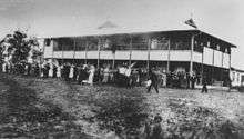
St Theresa's Agricultural College, Abergowrie, Queensland, circa 1932
The town is named after the Abergowrie property, selected by James Atkinson in 1883. He coined the name from the Celtic word aber (confluence) and gowrie for Gowrie Creek, reflecting the location.[1]
Abergowrie Post Office opened on 1 May 1953 and closed in 1974.[3]
In 1933, the St Teresa's Agricultural College was opened by the Christian Brothers.[2]
Education
Abergowrie has two schools:
- Abergowrie State School (state primary co-educational school)
- St. Teresa's College (Catholic secondary boys school)
References
- 1 2 "Abergowrie (entry 37)". Queensland Place Names. Queensland Government. Retrieved 8 January 2014.
- 1 2 "Abergowrie". Queensland Places. Centre for the Government of Queensland, University of Queensland. Retrieved 8 January 2014.
- ↑ Premier Postal History. "Post Office List". Premier Postal Auctions. Retrieved 10 May 2014.
External links
| Wikimedia Commons has media related to Abergowrie, Queensland. |
"Abergowrie". Queensland Places. Centre for the Government of Queensland, University of Queensland. Coordinates: 18°28′36″S 145°53′10″E / 18.4766°S 145.8862°E
This article is issued from Wikipedia - version of the 7/17/2016. The text is available under the Creative Commons Attribution/Share Alike but additional terms may apply for the media files.