Farafra, Egypt
Coordinates: 27°03′30″N 27°58′12″E / 27.05833°N 27.97000°E
| Farafra | |
|---|---|
 | |
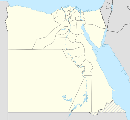 Farafra Location in Egypt | |
| Coordinates: 27°03′30″N 27°58′12″E / 27.05833°N 27.97000°E | |
| Country |
|
| Governorate | New Valley Governorate |
| Time zone | EST (UTC+2) |
The Farafra depression (Arabic: واحة الفرافرة pronounced [elfɑˈɾɑfɾɑ]) is the second biggest depression by size in Western Egypt and the smallest by population, near latitude 27.06° north and longitude 27.97° east. It is in the large Western Desert of Egypt, approximately midway between Dakhla and Bahariya oases.
Farafra has an estimated 5,000 inhabitants (2002) mainly living in the town of Farafra and is mostly inhabited by the local Bedouins. Parts of the town have complete quarters of traditional architecture, simple, smooth, unadorned, all in mud colour — local culture and traditional methods of building and carrying out repairs have been supported by its tourism. Often grouped within Farafra are the hot springs at Bir Sitta (the sixth well) and the El-Mufid lake.
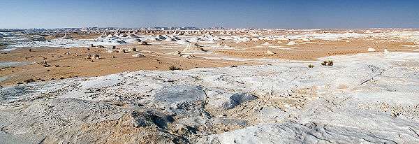
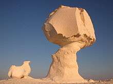
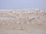
A main geographic attraction of Farafra is its White Desert (known as Sahara el Beyda, with the word sahara meaning a desert) — a national park of Egypt and 45 km (28 mi) north of the town of Farafra, the main draw of which is its rock type colored from snow-white to cream. It has massive chalk rock formations that are textbook examples of ventifact and which have been created as a result of occasional sandstorm in the area. The Farafra desert is a typical place visited by some schools in Egypt, as a location for camping trips. The desert was also the featured location in the music video accompanying the piece Echoes in the 2008–2011 album by the Klaxons.
"Jasrmmd road, and the locally developed clays at the top of the white chalk west of Qasr Farafra. As Zittel placed the beds at the former place below the White Chalk, this new position assigned to them may be regarded as provisional until confirmed or disproved by palaeontological evidence derived from the latter locality."[1]
Wells
The Roman spring of Ain Bishay bubbles forth from a hillock on the northwest edge of town. It has been developed into an irrigated grove of date palms together with citrus, olive, apricot and carob trees, and is a cool haven amid the arid landscape. Several families tend the crops here; you should seek someone out and ask permission before wandering around.— Sights in Qasr Al Farafra - Lonely Planet[2]
Due to its geographical location and geological formation it has more than 100 wells spread out over the lands of the Farafra, many of which natural. Most of these wells are used in aggregation of the cultivated land in the oasis. Some of the wells in Farafra have become a favorite tourist destination. Bir Sitta, (well 6 in Arabic), Bir Sab'a (well 7) and Bir Ithnian wa ishrin (well 22) are the most important. Because of the water's warm temperature and a slight percentage of sulfur, these wells are favorable for swimming and relaxation. There is a large lake touristic well named Abu Nus 15 kilometers north of the edge of the Farafra.[3]
Climate
Köppen-Geiger climate classification system classifies its climate as hot desert (BWh).
| Climate data for Farafra, Egypt | |||||||||||||
|---|---|---|---|---|---|---|---|---|---|---|---|---|---|
| Month | Jan | Feb | Mar | Apr | May | Jun | Jul | Aug | Sep | Oct | Nov | Dec | Year |
| Record high °C (°F) | 31.8 (89.2) |
37.2 (99) |
41.5 (106.7) |
46.4 (115.5) |
47.5 (117.5) |
47.8 (118) |
44.7 (112.5) |
45.1 (113.2) |
43.4 (110.1) |
42.6 (108.7) |
37.8 (100) |
31.2 (88.2) |
47.8 (118) |
| Average high °C (°F) | 20.0 (68) |
22.4 (72.3) |
26.2 (79.2) |
31.6 (88.9) |
35.4 (95.7) |
37.8 (100) |
37.8 (100) |
37.3 (99.1) |
35.1 (95.2) |
31.2 (88.2) |
25.5 (77.9) |
21.1 (70) |
30.1 (86.2) |
| Daily mean °C (°F) | 12.0 (53.6) |
14.0 (57.2) |
17.8 (64) |
22.8 (73) |
27.0 (80.6) |
29.4 (84.9) |
30.3 (86.5) |
29.9 (85.8) |
27.2 (81) |
23.1 (73.6) |
17.6 (63.7) |
13.6 (56.5) |
22.1 (71.8) |
| Average low °C (°F) | 4.1 (39.4) |
6.0 (42.8) |
9.2 (48.6) |
13.8 (56.8) |
17.9 (64.2) |
20.6 (69.1) |
21.9 (71.4) |
21.5 (70.7) |
19.5 (67.1) |
15.6 (60.1) |
10.1 (50.2) |
5.6 (42.1) |
13.8 (56.8) |
| Record low °C (°F) | −3.3 (26.1) |
−2.2 (28) |
−0.2 (31.6) |
2.9 (37.2) |
7.6 (45.7) |
13.9 (57) |
16.9 (62.4) |
16.8 (62.2) |
13.5 (56.3) |
7.3 (45.1) |
0.6 (33.1) |
−2.1 (28.2) |
−3.3 (26.1) |
| Average precipitation mm (inches) | 1 (0.04) |
0 (0) |
0 (0) |
0 (0) |
0 (0) |
0 (0) |
0 (0) |
0 (0) |
0 (0) |
0 (0) |
1 (0.04) |
0 (0) |
2 (0.08) |
| Average precipitation days (≥ 1.0 mm) | 0.1 | 0.1 | 0 | 0.1 | 0 | 0 | 0 | 0 | 0 | 0 | 0 | 0 | 0.3 |
| Average relative humidity (%) | 51 | 43 | 38 | 29 | 26 | 26 | 28 | 31 | 36 | 42 | 55 | 53 | 38.2 |
| Source #1: NOAA[4] | |||||||||||||
| Source #2: Climate Charts[5] | |||||||||||||
Gallery
| Farafra Desert | ||||||||||
|---|---|---|---|---|---|---|---|---|---|---|
|


References
- ↑ Geological Survey Report... Part 3 of Geological Survey Report, Geological Survey Report. Egypt. Maṣlaḥat al-Misāḥah. 1901. Page 35.
- ↑ Sights in Qasr Al Farafra."
- ↑ "Water Wells of Farafra."
- ↑ "Farafra Climate Normals 1961–1990". National Oceanic and Atmospheric Administration. Retrieved October 25, 2015.
- ↑ "Farafra, Egypt: Climate, Global Warming, and Daylight Charts and Data". Climate Charts. Retrieved 17 July 2013.
Bibliography
- Frank Bliss: 'Oasenleben. Die ägyptischen Oasen Bahriya und Farafra in Vergangenheit und Gegenwart'. Die ägyptischen Oasen Band 2. Bonn 2006.
- Frank Bliss: 'Artisanat et artisanat d’art dans les oasis du désert occidental égyptien'. "Veröffentlichungen des Frobenius-Instituts". Köln 1998.
- Beadnell, Hugh J. L. The Farafra Oasis: Its Topography and Geology. Geological Survey Report... Part 3 of Geological Survey Report, Geological Survey Report]. Egypt. Maṣlaḥat al-Misāḥah. 1901.
- Fakhry, Ahmed. 1974. Bahriyah and Farafra. Reissue of the Classic History and Description. Illustrated, reprint. Publisher: American Univ. in Cairo Press, 1974. ISBN 9774247329, 9789774247323. 189 pages.
External links
| Wikimedia Commons has media related to White Desert, Egypt. |
Egyptian oases | ||
|---|---|---|
 | ||
| ||