Arabian Desert
| The Arabian desert (Arabi Desert) | |
| Deserts | |
 A satellite image of the Arabian Desert by NASA World Wind. | |
| Countries | Jordan, Iraq, Kuwait, Oman, Qatar, Saudi Arabia, United Arab Emirates, Yemen |
|---|---|
| Landmark | Al-Nafūd Al-Sabʿatayn Dunes Āl Wahībah Dunes Rubʿ al-Khali |
| Highest point | Jabal an Nabi Shu'ayb 12,336 ft (3,760 m) |
| - coordinates | 18°16′2″N 42°22′5″E / 18.26722°N 42.36806°E |
| Length | 2,100 km (1,305 mi), E/W |
| Width | 1,100 km (684 mi), N/S |
| Area | 2,330,000 km2 (899,618 sq mi) |
| Biome | Desert |
The Arabian Desert is located in Western Asia. It is a vast desert wilderness stretching from Yemen to the Persian Gulf and Oman to Jordan and Iraq. It occupies most of the Arabian Peninsula, with an area of 2,330,000 square kilometers (900,000 sq mi). At its center is the Rub'al-Khali, one of the largest continuous bodies of sand in the world. Gazelles, oryx, sand cats, and spiny-tailed lizards are just some of the desert-adapted species that survive in this extreme environment, which features everything from red dunes to deadly quicksand. The climate is mostly dry (the major part receives around 100 mm of rain per year but some very rare places receives down to 50 mm), and temperatures oscillate between very high heat and seasonal night time freezes. It is part of the Deserts and xeric shrublands biome and the Palearctic ecozone. This ecoregion holds little biodiversity, although a few endemic plants grow here. Many species, such as the striped hyena, jackal and honey badger have become extinct in this area due to hunting, human encroachment and habitat destruction. Other species have been successfully re-introduced, such as the sand gazelle, and are protected at a number of reserves. Overgrazing by livestock, off-road driving, and human destruction of habitat are the main threats to this desert ecoregion.
Geology and geography
Detailed geological features:
- A corridor of sandy terrain known as the Ad-Dahna desert connects the large An-Nafud desert (65,000 km2 or 40,389 square mile) in the north of Saudi Arabia to the Rub' Al-Khali in the south-east.
- The Tuwaiq escarpment is a region of 800 km (500 mi) arc of limestone cliffs, plateaux, and canyons.
- Brackish salt flats: the quicksands of Umm al Samim
- The Wahiba sands of Oman: an isolated sand sea bordering the east coast
- The Rub' Al-Khali[4] desert is a sedimentary basin elongated on a south-west to north-east axis across the Arabian shelf. At an altitude of 1,000 metres (3,300 ft), the rock landscapes yield the place to the Rub' al Khali, vast wide of sand of the Arabian desert, whose extreme southern point crosses the centre of Yemen. The sand overlies gravel or gypsum plains and the dunes reach maximum heights of up to 250 m (820 ft). The sands are predominantly silicates, composed of 80 to 90% of quartz and the remainder feldspar, whose iron oxide-coated grains color the sands in orange, purple, and red
Ecology and natural resources
Some of natural resources available in the Arabian Desert are oil, natural gas, phosphates, and sulfur.
The Rub'al-Khali has very limited floristic diversity. There are only 37 species, 20 recorded in the main body of the sands and 17 around the outer margins. Among these 37 species, only one or two are endemic. Vegetation is very diffuse but fairly evenly distributed, with some interruptions of near sterile dunes.
Some typical plants are:
- Calligonum crinitum on dune slopes
- Cornulaca arabica (saltbush)
- Cyperus conglomeratus.
Other widespread species are:
- Dipterygium glaucum
- Limeum arabicum
- Zygophyllum mandavillei (Mandaville 1986).
Very little trees may be found except at the outer margin (typically Acacia ehrenbergiana and Prosopis cineraria).
Other species are a woody perennial Calligonum comosum and annual herbs such as Danthonia forskallii
Climate
The Arabian Desert has a subtropical, hot desert climate, close to the climate of the Sahara Desert, the world's largest hot desert located in North Africa. In fact, the Arabian Desert is an extension of the Sahara Desert over the Arabian peninsula. The climate is mainly hot and dry with plenty of sunshine throughout the year.
The rainfall amount is generally around 100 mm, and the driest areas can receive between 30 and 40 mm of annual rain. Such dryness remains very rare throughout the desert, however. There are hardly any hyperarid areas in the Arabian Desert, in contrast with the Sahara Desert, where more than half of the area is hyperarid (annual rainfall below 50 mm).
The sunshine duration is very high by global standards in the Arabian Desert, between 2,900 hours (66.2% of the daylight hours) and 3,600 hours (82.1% of the daylight hours) but is typically around 3,400 hours (77.6% of the daylight hours), which clearly indicates clear-sky conditions prevails over the region and cloudy periods are just intermittent. Even though the sun and moon is bright, the dust and humidity has a lower visibility for the traveler.
The temperatures remain high all year round. Average high temperatures in summer are generally over 40 °C (104 °F) at low elevations, and can even soar to 48 °C (114.8 °F) at extremely low elevations, especially along the Persian Gulf near the sea level. Average low temperatures in summer remain high, over 20 °C (68 °F) and sometimes over 30 °C (77 °F) in the southernmost regions. Record high temperatures are above 50 °C (122 °F) in much of the desert, due in part to very low elevation.
Political borders
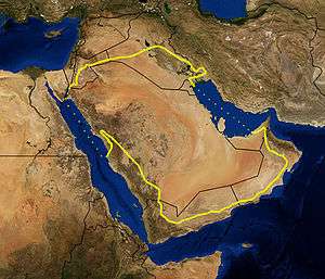
The desert lies mostly in Saudi Arabia, extending into the surrounding countries of Egypt (Sinai), southern Iraq and southern Jordan. The Arabian desert is bordered by 5 countries. Bordering the Persian Gulf, there is an extension into Qatar and, further east, the region covers almost all of Abu Dhabi in the United Arab Emirates (UAE). The Rub'al-Khali crosses over from Saudi Arabia into western Oman and eastern Yemen.
People, language and cultures
The area is home to several different cultures, languages, and peoples, with Islam as the predominant faith. The major ethnic group in the region is the Arabs, whose primary language is Arabic.
Ecological threats
- Agricultural projects
- Human destruction of habitat
- Military activity
- Oil and gas production
- Overgrazing by camels and goats, with increased herd size, and a more sedentary lifestyle amongst the Bedouin
Military activity
Weaponry used by the United States during the Gulf War also poses a huge risk to the environmental stability of the area. Tank columns in the desert plains may disrupt the fragile stability that exists in the desert currently. In 1991, the movement of US tanks over the desert damaged the top protective layer of the desert soil. As a result, a sand dune was released and has started slowly moving downhill.[5] Some people fear this dune could ultimately reach Kuwait City.[5] Another concern is related to the use of toxic depleted uranium munitions by the A-10 "Warthog". Some detractors claim the ammunition is a cancer risk and a source of water contamination. Also in 1991, the U.S. and NATO dropped nearly 300 tons of depleted uranium on Iraqi targets. The splinters resulting from the explosion contaminated the surrounding soil.
Conservation
The conservation status of the desert is critical/endangered, with species including the sand gazelle and white oryx threatened, and honey badgers, jackals, and striped hyaenas already extirpated.
No formal protected areas exist, but a number of protected areas are planned for Abu Dhabi.
Oil spills
This ecoregion was the victim of a massive economic-environmental challenge: the sabotage of Kuwait oil facilities that caused vast oil spills and the release of toxins into the atmosphere in the 1990s.
In January 1991 during the Gulf War, Iraqi forces released about 1.7 million m³ (11 million barrels) of oil from storage tanks and tankers directly into the Persian Gulf. In February, they also destroyed 1,164 Kuwaiti oil wells. It took nine months to extinguish these oil fires. These oil spills contaminated 1,000 km (620 mi) of Persian Gulf coast.
The result of the pollution was the death of thousands of water birds and serious damage to the Persian Gulf's aquatic ecosystem, particularly shrimp, sea turtles, dugongs, whales, dolphins and fish.
The damaged wells also released 10 million m³ (60 million barrels) of oil into the desert and formed lakes (total surface of 49 square kilometers).
References
- ↑ "Arabian Desert and East Sahero-Arabian xeric shrublands". Terrestrial Ecoregions. World Wildlife Fund.
- ↑ "Persian Gulf desert and semi-desert". Terrestrial Ecoregions. World Wildlife Fund.
- ↑ "Red Sea Nubo-Sindian tropical desert and semi-desert". Terrestrial Ecoregions. World Wildlife Fund.
- ↑ "Rub Al-Khali, a photo and short description". A Lovely World.