Alfalfa, Oklahoma
Not to be confused with Alfalfa County, Oklahoma.
| Alfalfa, Oklahoma | |
|---|---|
| Unincorporated community | |
 Alfalfa | |
| Coordinates: 35°13′08″N 98°36′26″W / 35.21889°N 98.60722°WCoordinates: 35°13′08″N 98°36′26″W / 35.21889°N 98.60722°W | |
| Country | United States |
| State | Oklahoma |
| County | Caddo |
| Elevation | 1,457 ft (444 m) |
| Time zone | Central (CST) (UTC-6) |
| • Summer (DST) | CDT (UTC-5) |
| Area code(s) | 405 |
| GNIS feature ID | 1089581[1] |
Alfalfa is an unincorporated community in Caddo County, Oklahoma, United States. Alfalfa is located on Oklahoma State Highway 58 8 miles (13 km) north of Carnegie.
References
Municipalities and communities of Caddo County, Oklahoma, United States | ||
|---|---|---|
| City | 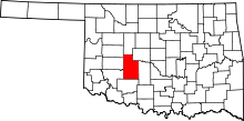 | |
| Towns | ||
| Unincorporated communities | ||
| Footnotes | ‡This populated place also has portions in an adjacent county or counties. | |
This article is issued from Wikipedia - version of the 2/24/2015. The text is available under the Creative Commons Attribution/Share Alike but additional terms may apply for the media files.