Allakaket, Alaska
| Allakaket Aalaa Kkaakk’et | |
|---|---|
| City | |
|
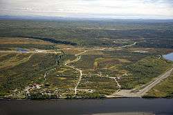
Aerial view of Allakaket | |
 Allakaket Location in Alaska | |
| Coordinates: 66°33′48″N 152°38′50″W / 66.56333°N 152.64722°WCoordinates: 66°33′48″N 152°38′50″W / 66.56333°N 152.64722°W | |
| Country | United States |
| State | Alaska |
| Census Area | Yukon-Koyukuk |
| Incorporated | 1975[1] |
| Government | |
| • Mayor | Valerie Bergman |
| • State senator | Donny Olson (D) |
| • State rep. | Benjamin Nageak (D) |
| Area | |
| • Total | 4.3 sq mi (11.2 km2) |
| • Land | 3.6 sq mi (9.3 km2) |
| • Water | 0.7 sq mi (1.9 km2) |
| Elevation | 400 ft (122 m) |
| Population (2010)[2] | |
| • Total | 105 |
| Time zone | Alaska (AKST) (UTC-9) |
| • Summer (DST) | AKDT (UTC-8) |
| ZIP code | 99720 |
| Area code | 907 |
| FIPS code | 02-01860 |
Allakaket (/æləˈkækᵻt/ al-ə-KAK-ət) (Aalaa Kkaakk’et in Koyukon) is a 2nd Class City in the Yukon-Koyukuk Census Area of the Unorganized Borough of the U.S. state of Alaska. The population was 105 at the 2010 census.[2]
History and culture
Several Native groups have lived in the area, including Koyukon Athabascans and Kobuk, Selawik, and Nunamiut Eskimos from the north and northwest. The Koyukon lived in several camps throughout the year, moving as the seasons changed, following the wild game and fish. The various bands established joint settlements after 1851. The old site of Alatna was a traditional trading center for Athabascans and Eskimos.
The first mission on the Koyukuk River, St. John's-in-the-Wilderness Episcopal Mission, was established in 1906. A post office was opened in 1925. In 1938, the name of the community was changed to Allakaket (the old name for the mission), and the name Alatna was assumed by the small Eskimo community across the river. The first public school was established in 1957. A flood caused by ice jamming inundated 85% of the community in the Spring of 1964. In 1975, the community incorporated as a City, including both settlements of Allakaket and Alatna. A clinic and airport were built in 1978. A new school and community roads were built in 1979. In September 1994, flood waters destroyed and swept away nearly all of the community's buildings, homes, and food caches for the winter. Residents rebuilt near the old City site, but some new homes and facilities are now located outside of the incorporated City boundaries. New Allakaket and Alatna are located outside of the City limits.
A federally recognized tribe is located in the community—the Allakaket Village. The population of the community consists of 95.9% Alaska Native or part Native. Allakaket is mainly an Athabascan community; Kobuk Eskimos live across the river in Alatna. Two separate village councils exist. Traditional potlatches, dances and foot races attract visitors from area villages. Subsistence activities provide the majority of food sources. Sale, importation, and possession of alcohol are banned in the village.
Geography
Allakaket is located at 66°33′48″N 152°38′50″W / 66.56333°N 152.64722°W (66.562610, -152.64756)[3] (Sec. 14, T020N, R024W, Fairbanks Meridian.) Allakaket is located in the Fairbanks Recording District.
Allakaket is on the south bank of the Koyukuk River, southwest of its junction with the Alatna River, approximately 190 miles (310 km) northwest of Fairbanks and 57 miles (92 km) upriver from Hughes. The village of Alatna is located directly across the river.
According to the United States Census Bureau, the city has a total area of 4.3 square miles (11 km2), of which, 3.6 square miles (9.3 km2) of it is land and 0.7 square miles (1.8 km2) of it (17.05%) is water.
Climate
The area experiences a cold, continental climate with extreme temperature differences. According to the Köppen climate classification system, Allakaket has a continental subarctic climate (Dfc). The average high temperature during July is 70 °F (21 °C). The average low temperature during January is well below zero and extended periods of −40 °F (−40 °C) are common. The highest temperature ever recorded was 94 °F (34 °C) and the lowest was −75 °F (−59 °C). Average precipitation is 13 inches (330 mm) and annual snowfall is 72 inches (1,800 mm). The Koyukuk River is ice-free from June through October.
| Climate data for Allakaket | |||||||||||||
|---|---|---|---|---|---|---|---|---|---|---|---|---|---|
| Month | Jan | Feb | Mar | Apr | May | Jun | Jul | Aug | Sep | Oct | Nov | Dec | Year |
| Record high °F (°C) | 36 (2) |
35 (2) |
43 (6) |
59 (15) |
83 (28) |
90 (32) |
94 (34) |
88 (31) |
76 (24) |
55 (13) |
41 (5) |
38 (3) |
94 (34) |
| Average high °F (°C) | −10.3 (−23.5) |
−2.1 (−18.9) |
13.9 (−10.1) |
33.6 (0.9) |
54.9 (12.7) |
68 (20) |
70.7 (21.5) |
65 (18) |
50.6 (10.3) |
27 (−3) |
4.2 (−15.4) |
−3.9 (−19.9) |
31 (−1) |
| Average low °F (°C) | −30.3 (−34.6) |
−30.4 (−34.7) |
−21.4 (−29.7) |
4.1 (−15.5) |
30 (−1) |
42.3 (5.7) |
44.9 (7.2) |
39.3 (4.1) |
27.7 (−2.4) |
8.9 (−12.8) |
−17.1 (−27.3) |
−29.6 (−34.2) |
5.7 (−14.6) |
| Record low °F (°C) | −75 (−59) |
−70 (−57) |
−63 (−53) |
−42 (−41) |
−8 (−22) |
17 (−8) |
21 (−6) |
17 (−8) |
−4 (−20) |
−40 (−40) |
−59 (−51) |
−69 (−56) |
−75 (−59) |
| Average precipitation inches (mm) | 0.89 (22.6) |
0.58 (14.7) |
0.44 (11.2) |
0.33 (8.4) |
0.51 (13) |
1.29 (32.8) |
1.82 (46.2) |
2.14 (54.4) |
1.36 (34.5) |
1.2 (30) |
1.09 (27.7) |
0.75 (19) |
12.41 (315.2) |
| Average snowfall inches (cm) | 12.6 (32) |
8.1 (20.6) |
6.3 (16) |
2.4 (6.1) |
0.1 (0.3) |
0 (0) |
0 (0) |
0 (0) |
0.7 (1.8) |
9.7 (24.6) |
10.9 (27.7) |
10.5 (26.7) |
61.3 (155.7) |
| Average precipitation days | 6 | 5 | 4 | 4 | 6 | 9 | 10 | 13 | 10 | 9 | 7 | 7 | 90 |
| Source: [4] | |||||||||||||
Demographics
| Historical population | |||
|---|---|---|---|
| Census | Pop. | %± | |
| 1940 | 105 | — | |
| 1950 | 79 | −24.8% | |
| 1960 | 115 | 45.6% | |
| 1980 | 163 | — | |
| 1990 | 170 | 4.3% | |
| 2000 | 97 | −42.9% | |
| 2010 | 105 | 8.2% | |
| Est. 2015 | 104 | [5] | −1.0% |
As of the census[7] of 2000, there were 97 people, 41 households, and 18 families residing in the city. The population density was 27.0 people per square mile (10.4/km²). There were 59 housing units at an average density of 16.4 per square mile (6.3/km²). The racial makeup of the city was 4.12% White, and 95.88% Native American.
There were 41 households out of which 26.8% had children under the age of 18 living with them, 31.7% were married couples living together, 7.3% had a female householder with no husband present, and 53.7% were non-families. 53.7% of all households were made up of individuals and 2.4% had someone living alone who was 65 years of age or older. The average household size was 2.37 and the average family size was 3.68.
In the city the age distribution of the population shows 23.7% under the age of 18, 19.6% from 18 to 24, 22.7% from 25 to 44, 25.8% from 45 to 64, and 8.2% who were 65 years of age or older. The median age was 32 years. For every 100 females there were 142.5 males. For every 100 females age 18 and over, there were 155.2 males.
The median income for a household in the city was $16,563, and the median income for a family was $33,125. Males had a median income of $13,750 versus $35,417 for females. The per capita income for the city was $10,912. There were 11.8% of families and 12.9% of the population living below the poverty line, including 12.5% of under eighteens and none of those over 64.
Public services
Most public facilities were severely damaged in the 1994 Koyukuk River flood. Major components have been replaced—a new washeteria, well and treatment plant, 100,000 US gallons (380,000 l) water storage tank, sewage lagoon, and force main have recently been completed. The lagoon is connected to the washeteria and school. Residents carry treated water and haul honeybuckets or use pit privies; no households have plumbing. Infrastructure improvements to provide a flush/haul system are continuing. A new landfill and access road are also under construction. Electricity is provided by Alaska Power Company. There is one school located in the community, attended by 52 students. Local hospitals or health clinics include Allakaket Health Clinic (907-968-2248). Allakaket Health Clinic is a Primary Health Care facility. Allakaket is classified as an isolated village, it is found in EMS Region 1C in the Interior Region. Emergency Services have river and air access. Emergency service is provided by a health aide.
The Yukon-Koyukuk School District operates the Allakaket School.[8]
Economy and transportation
Most cash jobs are part-time or seasonal. The primary year-round employers are the school, City, Tribe and village corporation store. Construction and BLM emergency firefighting provide summer jobs. A few earn income from trapping or selling traditional Native handicrafts. Subsistence is the focus of the local economy. Salmon, whitefish, moose, bear, small game and berries provide most food sources. Caribou are taken when available.
Allakaket has no road link, but winter trails connect it with Hughes, Bettles and Tanana. River transportation is important in summer, but there is no commercial barge access due to shallow water. The state-owned Allakaket Airport has a 4,000 by 100 ft (1,219 by 30 m) gravel runway and is accessible year-round. A $6 million airport improvement began construction in 1997. Arctic Circle Air Service, Frontier Flying Service, Servant Air, Warbelow's Air Ventures, and Wright Air Service offer passenger flight service.
Taxes
Sales: None, Property: None, Special: None
References
- ↑ 1996 Alaska Municipal Officials Directory. Juneau: Alaska Municipal League/Alaska Department of Community and Regional Affairs. January 1996. p. 22.
- 1 2 "Profile of General Population and Housing Characteristics: 2010 Demographic Profile Data". United States Census Bureau, American FactFinder. Retrieved 2012-11-14.
- ↑ "US Gazetteer files: 2010, 2000, and 1990". United States Census Bureau. 2011-02-12. Retrieved 2011-04-23.
- ↑ "ALLAKAKET, AK (500230)". Western Regional Climate Center. Retrieved November 18, 2015.
- ↑ "Annual Estimates of the Resident Population for Incorporated Places: April 1, 2010 to July 1, 2015". Retrieved July 2, 2016.
- ↑ "Census of Population and Housing". Census.gov. Archived from the original on May 11, 2015. Retrieved June 4, 2015.
- ↑ "American FactFinder". United States Census Bureau. Archived from the original on September 11, 2013. Retrieved 2008-01-31.
- ↑ "Allakaket School, Allakaket." Yukon-Koyukuk School District. Retrieved on June 16, 2016.
External links
- Allakaket at the Community Database Online from the Alaska Division of Community and Regional Affairs
- Maps from the Alaska Department of Labor and Workforce Development: 2000, 2010
Municipalities and communities of Yukon–Koyukuk Census Area, Alaska, United States | ||
|---|---|---|
| Cities | 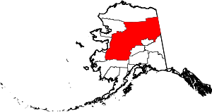 | |
| CDPs | ||
| Unincorporated communities | ||
| Ghost towns | ||