Almagro, Samar
| Almagro | |
|---|---|
| Island Municipality | |
|
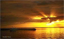
Sunset in Almagro Samar | |
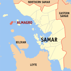 Map of Samar with Almagro highlighted | |
.svg.png) Almagro Location within the Philippines | |
| Coordinates: 11°55′N 124°17′E / 11.917°N 124.283°ECoordinates: 11°55′N 124°17′E / 11.917°N 124.283°E | |
| Country | Philippines |
| Region | Eastern Visayas (Region VIII) |
| Province | Samar |
| Congr. district | 1st district of Samar |
| Barangays | 23 |
| Government[1] | |
| • Mayor | Kathleen S. Prudenciado |
| Area[2] | |
| • Total | 51.36 km2 (19.83 sq mi) |
| Population (2010)[3] | |
| • Total | 11,024 |
| • Density | 210/km2 (560/sq mi) |
| Time zone | PST (UTC+8) |
| ZIP code | 6724 |
| Dialing code | 55 |
Almagro is a fifth class island municipality in the province of Samar, Philippines. According to the 2010 census, it has a population of 11,024.[3]
Barangays
Almagro is politically subdivided into 23 barangays.[2]
- Bacjao
- Biasong I
- Costa Rica
- Guin-ansan
- Kerikite
- Lunang I (Look)
- Lunang II
- Malobago
- Marasbaras
- Panjobjoban I
- Poblacion
- Talahid
- Tonga-Tonga
- Imelda (Badjang)
- Biasong II
- Costa Rica II
- Mabuhay
- Magsaysay
- Panjobjoban II
- Roño
- San Isidro
- San Jose
- Veloso
Demographics
| Population census of Almagro | ||
|---|---|---|
| Year | Pop. | ±% p.a. |
| 1990 | 8,578 | — |
| 1995 | 10,270 | +3.43% |
| 2000 | 10,619 | +0.72% |
| 2007 | 8,650 | −2.79% |
| 2010 | 11,024 | +9.23% |
| Source: National Statistics Office[3][4] | ||
Tourist attractions
- Pang-pang (Veloso and Panjobjoban 1)
- Exotic Diving Resort (Brgy. Kerikite)
- Caves in Almagro
- Rock formation
- Museum of Endangered Species
- LightHouse (lighthouse island)
- Almagro Disneyland and
- Almagro Ocean Park
Culture
The most famous dance in Almagro is Kuratsa, because of the influence of the Spaniards that controlled the municipality for 330 years. They held their occasions on the newly constructed Covered Court in Brgy. Poblacion. Their Fiestas and Charter Days are the days where many people would come to Almagro to witness different activities held on the island. People in Almagro are often seen wearing sando because of the hot weather and the sea breeze on the island.
Transportation
The only one means of access to Almagro is by motorboat from the port of Calbayog City, taking usually up to 2 hours of travel.
References
- ↑ "Municipalities". Quezon City, Philippines: Department of the Interior and Local Government. Archived from the original on 31 May 2013. Retrieved 14 May 2013.
- 1 2 "Province: Samar (Western Samar)". PSGC Interactive. Makati City, Philippines: National Statistical Coordination Board. Retrieved 14 May 2013.
- 1 2 3 "Total Population by Province, City, Municipality and Barangay: as of May 1, 2010" (PDF). 2010 Census of Population and Housing. National Statistics Office. Retrieved 14 May 2013.
- ↑ "Province of Western Samar". Municipality Population Data. LWUA Research Division. Retrieved 21 August 2013.
External links
- Philippine Standard Geographic Code
- Philippine Census Information
- Local Governance Performance Management System
 |
Tagapul-an Samar Sea |
| ||
| Pio V. Corpuz, Masbate / Samar Sea | |
Samar Sea / Santo Niño | ||
| ||||
| | ||||
| Samar Sea Maripipi, Biliran |
Catbalogan (capital) | |
| Municipalities | |
| Component cities | |