Alonnisos
| Alonnisos Αλόννησος | |
|---|---|
|
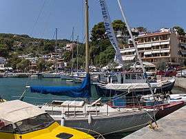
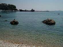
Port of Alonnisos | |
 Alonnisos | |
|
Location within the region 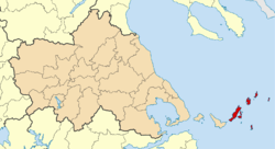 | |
| Coordinates: 39°9′N 23°50′E / 39.150°N 23.833°ECoordinates: 39°9′N 23°50′E / 39.150°N 23.833°E | |
| Country | Greece |
| Administrative region | Thessaly |
| Regional unit | Sporades |
| Area | |
| • Municipality | 129.6 km2 (50.0 sq mi) |
| Highest elevation | 476 m (1,562 ft) |
| Lowest elevation | 0 m (0 ft) |
| Population (2011)[1] | |
| • Municipality | 2,750 |
| • Municipality density | 21/km2 (55/sq mi) |
| Time zone | EET (UTC+2) |
| • Summer (DST) | EEST (UTC+3) |
| Postal code | 370 05 |
| Area code(s) | 24240 |
| Vehicle registration | BO |
| Website | www.alonissos.gov.gr |

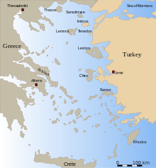
Alonnisos (Greek: Αλόννησος), also transliterated as Alonissos or Alonisos, is a Greek island in the Aegean Sea. After Skiathos and Skopelos it is the third member of the Northern Sporades. It is 3 km (2 mi) (2 nm) E of the island of Skopelos. Alonnisos is also the name of a village on the island, as well as the municipality that encompasses the island and the village.
The village of Alonnisos is located on the southern part of the island. It is locally known as Chora and signposted as The Old Village. The main port of the island is located in the southeast and is called Patitiri. There are ferry, catamaran ("flying cat") and hydrofoil ("flying dolphin") services from Patitiri to Volos, Agios Konstantinos, and Thessaloniki on the mainland and to the islands of Skiathos, Skopelos and Skyros. The bay at the southern end of the island is also called Alonnisos.
The Municipality of Alonnisos includes the nearby islands of Adelfoi, Gioura, Kyra Panagia (Pelagos), Peristera, Piperi, Psathoura and Skantzoura.
History
In the Middle Ages and until the 19th century, the island was known as Liadromia (Λιαδρόμια). It was renamed in 1838, as it was – mistakenly according to later research – identified with Alonnisos of Antiquity. In reality, the present island of Alonnisos was known as Ikos (Ίκος) to the Ancient Greeks.
Geography
The island at its widest is 4.5 kilometres (3 miles) from northwest to southeast and at its longest is 20 kilometres (12 miles) from southwest to northeast. The area of the island is 64 km2. The island is mostly limestone. It is located east of mainland Greece and Magnesia, northeast of Euboea and northwest of the island of Skyros.
The island

Agriculture is widespread on Alonnisos, predominantly mixed farming and vineyards. The main products are almonds, grapes, figs and olives. Spruce trees are abundant on the island. While fishing is a popular profession on the island, tourism is now the main industry.
Housing traditionally consists of closely constructed houses with stone walls, which, until 1965, were centered on the capital. A small fortress protected against enemies and pirates. The island and the village were heavily damaged in the 1965 earthquake. Many inhabitants returned not to the village of Alonnisos, but to Patitiri. The old village has been restored in recent years, with rebuilt houses now utilised for tourism.
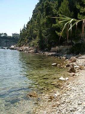
The beaches around the island consist of pebbles. The ecosystem in the north side of the island is in good condition. The Mediterranean monk seal (Monachus-Monachus) is common around the island, and in 1992 the Alonnisos Marine Park was created to protect these seals and other animals.
Communities and subdivisions
The Municipality includes several other islands with small resident populations. The total land area of the municipality is 129.607 km2 (50.042 sq mi).[2] The 2011 census population was 2,750 inhabitants, of whom only 38 persons lived on the other islands.
Alonnisos Island
- Ágios Pétros (Άγιος Πέτρος)
- Alónnisos (Αλόννησος)
- Chrysi Milia (Χρυσή Μηλιά)
- Gérakas (Γέρακας)
- Isiomata (Ισιώματα)
- Kalamákia (Καλαμάκια)
- Marpounta (Μαρπούντα) - abandoned
- Mourtero (Μουρτερό)
- Patitiri (Πατητήρι)
- Steni Vala (Στενή Βάλα)
- Votsi (Βότση)
Other islands
- Adelfoi (Αδελφοί)
- Gioura (Γιούρα)
- Kyra Panagia (Κυρά Παναγιά)
- Peristera (Περιστέρα)
- Piperi (Πιπέρι)
- Psathoura (Ψαθούρα)
- Skantzoura (Σκάντζουρα)
Historical population
| Year | Population |
|---|---|
| 1991 | 2,985 |
| 2001 | 2,700 |
| 2011 | 2,750 |
| 2012 | 2,398 |
| 2015 | 2,069 |
References
- ↑ "Απογραφή Πληθυσμού - Κατοικιών 2011. ΜΟΝΙΜΟΣ Πληθυσμός" (in Greek). Hellenic Statistical Authority.
- ↑ "Population & housing census 2001 (incl. area and average elevation)" (PDF) (in Greek). National Statistical Service of Greece.
External links
| Wikimedia Commons has media related to Alonissos. |
| Wikivoyage has a travel guide for Alonnisos. |
- Official website (English) (Greek)
- National Marine Park of Alonnisos Northern Sporades (English) (Greek)
- VivaSporades.com (English) (Greek)
- Alonnisos.net website (English) (Greek)
Administrative division of the Thessaly Region | ||
|---|---|---|
| Regional unit of Karditsa |  | |
| Regional unit of Larissa | ||
| Regional unit of Magnesia | ||
| Regional unit of the Sporades | ||
| Regional unit of Trikala | ||
| ||