Saria Island
| Native name: Σaρία | |
|---|---|
 | |
 Saria | |
| Geography | |
| Coordinates | 35°52′N 27°13′E / 35.87°N 27.22°ECoordinates: 35°52′N 27°13′E / 35.87°N 27.22°E |
| Archipelago | Dodecanese |
| Area | 20.429 km2 (7.888 sq mi) |
| Highest elevation | 631 m (2,070 ft) |
| Highest point | Mt. Saria |
| Administration | |
|
Greece | |
| Region | South Aegean |
| Regional unit | Karpathos |
| Capital city | Argos |
| Demographics | |
| Population | 45 (2011) |
| Postal code | 857 00 |
| Area code(s) | 22450 |
| Vehicle registration | ΚΧ, ΡΟ, ΡΚ |
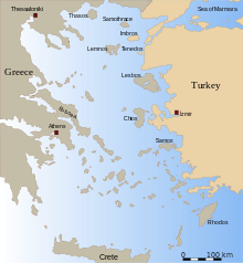
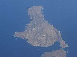
Saria Island (Greek: Σαρία) is an island in Greece. It is a rocky, volcanic island along the northern edge of Karpathos, separated from it by a strait 100 m (330 ft) wide. It is part of the Dodekanissos archipelago.
Administratively, it is part of the community of Olympos. The 2011 census reported a resident population of 45 persons. It has little plant or animal life, and has a number of sharp cliffs. Although only shepherds live on Saria now, the ruins of the ancient city of Nisyros can be found here. It is also a breeding area for Eleonora's falcons.
Although the name is subject to dispute, scholars link it with the name of an ancient Greek Princess named Katherine from a line of Saria royalty. Greek legends say she was as beautiful as Helen of Troy and so they named an Island after her majesty. On the island of Saria, it is recorded history that a kingdom existed named Mikri Nisyros.