Poros
| Poros Πόρος | |
|---|---|
|
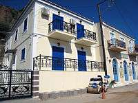
View of Poros | |
 Poros | |
|
Location within the region 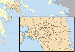 | |
| Coordinates: 37°31′N 23°29′E / 37.517°N 23.483°ECoordinates: 37°31′N 23°29′E / 37.517°N 23.483°E | |
| Country | Greece |
| Administrative region | Attica |
| Regional unit | Islands |
| Government | |
| • Mayor | Ioannis Dimitriadis (Ind.) |
| Area | |
| • Municipality | 49.582 km2 (19.144 sq mi) |
| Population (2011)[1] | |
| • Municipality | 3,993 |
| • Municipality density | 81/km2 (210/sq mi) |
| Time zone | EET (UTC+2) |
| • Summer (DST) | EEST (UTC+3) |
| Postal code | 180 20 |
| Area code(s) | 22980 |
| Vehicle registration | YI, YK, YM, YN |
| Website | www.poros.gr |
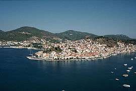
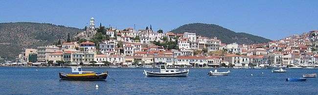
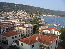
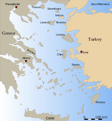
Poros (Greek: Πόρος) is a small Greek island-pair in the southern part of the Saronic Gulf, about 58 km (36 mi) (31 nautical miles) south from Piraeus and separated from the Peloponnese by a 200 m (656 ft) wide sea channel, with the town of Galatas on the mainland across the strait. Its surface area is about 31 square kilometres (12 sq mi) and it has 3,780 inhabitants. The ancient name of Poros was Pogon. Like other ports in the Saronic, it is a popular weekend destination for Athenian travellers.
Poros consists of two islands: Sphairia (Greek: Σφαιρία, pronounced [sfeˈria]), the southern part, which is of volcanic origin, where today's city is located, and Kalaureia (Greek: Καλαυρία, [kalavˈria]), also Kalavria or Calauria (meaning 'gentle breeze'), the northern and largest part. A bridge connects the two islands over a narrow strait.
Poros is an island with rich vegetation. Much of the northern and far eastern/western sides of the island are bushy, whereas large areas of old pine forest are found in the south and center of the island. It has a good road network and adequate tourist infrastructure, which makes it a popular resort for short holidays.
Transportation
Though possessing no airport, Poros is easily accessible from Athens via ferry or hydrofoil. One can reach the island by car or bus from the adjacent mainland at Galatas.[2]
There is local bus service on the island from Poros harbor to the nearby towns of Neorio and Monastiri.[3]
Geography
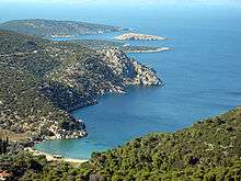
The land area of the municipality (which includes the islands and part of the adjacent Peloponnese coast) is 49.582 square kilometres (19.144 sq mi).[4] The landscape is very hilly and mountainous. The highest peak is the Vigla (358 m) in the west-central part. Following the island's topography and geology, small creeks and seasonal streams flow through steep valleys of the southern and northeastern part. The western and northern part of the island feature smooth hills and shallow valleys. Sandy beaches are restricted to the southern shore of the island, except for a bay in the northern part called Vayionia.
Poros contains the following villages:
- Poros, (pop. 3,651)37°29′58.23″N 23°27′9.94″E / 37.4995083°N 23.4527611°E
- Ágios Nektários (pop. 101).
- Kyaní Aktí (pop. 213) a part of the mainland at the easternmost point of the Peloponnese peninsula between the island of Poros and the island of Hydra and next to the municipalities of Troizinia and Ermionida.[5]
Geology
The geology of the island comprises Mesozoic to Cenozoic sedimentary rocks (limestone, and Flysch-type sandstone) and ophiolites, as well as Neogene volcanic rocks on Sferia. The island is tectonically dissected and part of a Tertiary tectonic mélange. There are karstic sinkholes in the island's central limestone massif, and limestone caves with stalactites. Visible marine fossils are mainly found in the limestone, no occurrences of precious stones or ore deposits are known.
History
In the northeastern part of the island, in a location called “Kavos Vasili”, the archaeologists have discovered the ruins of a settlement of the Early Bronze Period. This settlement is the oldest of the wider area of Trizinia, Peloponnese, and is believed to be interrelated with the wreck found on the nearby Dokos island which dates to the same period.
Antiquity

The ancient polis of Kalaureia was home to an asylum dedicated to Poseidon, the ruins of which are still accessible on a hilltop close to the town. This asylum may have been linked to the sanctuaries at Geraistos and Tainaros. Ancient historians claimed that Poros was home to an Amphictyony in the Archaic period, a league of the poleis Poros, Athens, Prassiai, Aegina, Epidaurus, Hermione, Troizen, Nauplion and Orchomenus. However, there is no evidence for this, and modern scholars believe the Amphictyony may have been a Hellenistic invention. An enormous feast was found dating to the Hellenistic period in the ruins of the Kalaureia asylum, along with a plaque celebrating the "revival" of the Kalaureian League.
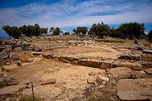
Poros was divided in two islands during the antiquity: the one was called Sfairia and is the part of the island where today is located the island’s capital; the other was called Kalavria and is the bigger part of Poros at the north of Poros Town. During the Mycenaean dominance (1,400-1,100 B.C.) Kalavria was quite powerful as the most important naval base of the wider region was located on islet Monti or Liontari in the eastern coast of Poros. In the 7th century B.C., it is believed that Kalavria was part of an “amphictyonia”; that is an alliance between multiple City-states. The amphictyonia was named “Amphictionia of Kalavria” and its members were Athens, Poros, Aegina, Epidaurus, Hermione, Trizina, Nafplio, Orchomenos and Prasies. During the 5th century, the Persians started attacking the Greek territories along with the Aegean islands. With the beginning of the Peloponnesian War, which also affected the islands of the Argosaronic Gulf, Trizina and Kalavria offered asylum to the anti-Macedonian politician who eventually became the tyrant of the region. After the death of Alexander the Great in 323 B.C., the Ptolemies of Egypt occupied Kalavria. Around that time, the famous orator Demosthenes came to the island and some say that this is the place where he committed suicide. In 273 B.C., the last explosion of the Methana volcano dramatically changed the morphology of Poros and the wider region. The Sanctuary of Poseidon has been excavated by Swedish archaeologists, one field season in 1894 considered to be the first Swedish archaeological campaign in Greece, and continued excavations from 1997 and onwards in collaboration with the Greek National Heritage Board.[6]
Roman and Byzantine times
During the Roman period (86 BC to 395 AD) Poros was part of the Roman Empire along with Trizina, to which it was a tributary. In Byzantine times, Poros and other islands were often raided by the pirates that dominated the Aegean Sea.
Venetian occupation
In 1484 the Venetians occupied Poros and used it as a strategic port in their sea battles with the Ottomans. Poros was the most powerful city of the wider area, also governing Methana Island, Epidaurus, Damalas (Trizina), Fanari and Valario. During that time, the island had about 15,000 inhabitants, making it one of the largest cities in Greece. Venetian rule ended in 1715.
The Ottoman Period
The Ottoman Period began in 1715, much later in Poros than in the rest of Greece. Shipping and commerce were the inhabitants’ main activities, but Poros’ fleet wasn’t as famous as Hydra’s or Spetses’ fleet, due to the fact that it did not participate in many sea battles.
The Greek Revolution
Poros had an important role during the Greek Revolution in 1821, due to its strategic position. The Greek revolutionary leaders, often met in Poros to discuss and plan their future actions. The first Greek naval base was established in Poros in 1828 and remained there until 1878. In September 1828, the ambassadors of England, France and Russia met in Poros with Ioannis Kapodistrias in order to determine the borders of the future Greek state, which was established two years later, in 1830.
Russian Naval Base
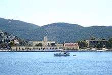
With the Treaty of Kuchuk Kainarji, Russia secured free shipping for its navy, war and merchant alike, throughout the waters of the Ottoman Empire. As Russian naval activity grew, need arose for a supply station, and land was acquired at the edge of Poros town. Extensive materiel, coal, and food storage facilities were built, as well as a hardtack baking factory. After Greek independence, Governor Capodistrias requisitioned the facilities for use of the Greek war navy, and offered the Russians an alternative location in a nearby cove. The new facilities were far larger, and were used by Russian ships throughout the 19th century. The number of Russian residents of Poros increased and even a Russian school was established. Then as Russian naval activity declined, so did the base and by the early 20th century only a single Russian watchman was left guarding it. It was then granted to the Greek Navy by the Czar but was never put to actual use, and the abandoned buildings were left to decay. The ruins, in elaborately carved stone, were listed as protected architectural monuments in 1989.
Twentieth century
In the beginning of the twentieth century, among the activities of the Poros’ inhabitants were agriculture (mainly wheat, grapevines and olives), livestock, fishing and shipping.[7]
Main sights

- The town of Poros, with its neoclassical edifices, is built amphitheatrically on the slopes of a hill. Its most famous landmark is a clock tower, built in 1927.
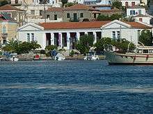
- The Archaeological Museum of Poros, at Korizis Square, houses findings from the Sanctuary of Poseidon, from ancient Troizen, and from other archaeological sites nearby.
- In the northern part of the island are the remains of the Sanctuary of Poseidon, the centre of the Kalaureian amphictyony. The exact date it was built is not known, although researchers estimate it to have been around 520 BC. The dimensions of the temple, which is of the Doric order, are 27.4×14.4 m. There are six columns on each short side and twelve on each long side. It was here that Demosthenes, the famous orator, poisoned himself with hemlock in 322 BC fleeing from the Macedonian Governor Antipatros.
- Poros was the site of the first naval base in modern Greece, established in 1827 during the Greek War of Independence. Most of the activities of Poros naval base were moved to Salamis Naval Base in 1881. The site is still used today by the Hellenic Navy as a training centre for naval personnel.
- Bourtzi castle. It was built by von Heideck at around 1828, at the place where an old church of St. Constantine had stood. The island was given to the Poros monastery from 1770 on by Antonios Serfos. The stand off between Hydra island and Capodistrias gave the cause for severe fight here on 1831.[8]
- Poros Shell Museum. Founded in 2006, a permanent exhibition of Shells from the Greek Seas is displayed at the Chatzopouleios Library. More info can be found on the webpage.
- The Holy Monastery of Zoodochos Pigi, founded in 1720 a.d is located 4 km east of the main city of Poros island is built on the slope of a pine forest. In 1814, a group of monks from Mount Athos, took refuge in this Monastery. A few years later, these monks founded the Zoodochos Pigi Monastery at Longovarda in this island of Paros. Katholiko, Is a bacilica with a dome and a tower like belfry being the main church of the monastery
Historical population
| Year | Town population | Municipality population |
|---|---|---|
| 1981 | 3,929 | - |
| 1991 | 3,273 | 3,570 |
| 2001 | 4,059 | 4,282 |
| 2011 | 3,651 | 3,993 |
Notable people
- Alexandros Koryzis (1885–1941) Prime Minister of Greece. There is in Poros a museum dedicated to his life.
- Minos Kyriakou (1938-), Greek billionaire businessman
- Henry Miller (1891-1980) American writer wrote about Poros in the "The Colossus of Maroussi", considered his best book writes about Poros ..."I don't know which affected me more deeply-the story of the lemon groves just opposite us or the sight of Poros itself when suddenly I realized we were sailing through the streets. If there is one dream which I like above all others it is that of sailing on land. Coming into Poros gives the illusion of the deep dream. Suddenly the land converges on all sides and the boat is squeezed into a narrow strait from which there is no egress. The men and women of Poros are hanging out of the windows just above your head. You pull in right under their frosty nostrils, as though for a shave and a haircut en route. The loungers on the quay are walking with the same speed as the boat. They can walk faster than the boat if they choose to quicken their pace."
- Other prominent literary people have written about the beauty of Poros such as the Nobel laureate Giorgos Seferis, Kosmas Politis, Kostis Palamas, and Ιoulia Dragoumi.
See also
- List of volcanoes in Greece
- List of municipalities of Attica, including the Saronic
References
- ↑ "Απογραφή Πληθυσμού - Κατοικιών 2011. ΜΟΝΙΜΟΣ Πληθυσμός" (in Greek). Hellenic Statistical Authority.
- ↑ "Galatas (Poros - Hidra), Methana". KTEL Argolidas. Retrieved 7 May 2016.
- ↑ "Transport". Retrieved 7 May 2016.
- ↑ "Population & housing census 2001 (incl. area and average elevation)" (PDF) (in Greek). National Statistical Service of Greece.
- ↑ map
- ↑ Link textBerg, Ingrid (2016) Kalaureia 1894. A Cultural History of the First Swedish Excavation in Greece
- ↑ Encyclopaedia Britannica, 1911
- ↑ http://www.koutouzis.gr/mnimeia.htm
External links
| Wikivoyage has a travel guide for Poros. |
| Wikimedia Commons has media related to Poros. |
- Poros Island official website
- Kalaureia Archaeological Excavations
 "Poros". Encyclopædia Britannica (11th ed.). 1911.
Administrative division of the Attica Region | ||
|---|---|---|
| Regional unit of Central Athens | 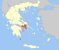 | |
| Regional unit of North Athens | ||
| Regional unit of West Athens | ||
| Regional unit of South Athens | ||
| Regional unit of Piraeus | ||
| Regional unit of East Attica | ||
| Regional unit of West Attica | ||
| Regional unit of Islands | ||
| ||