Alto Alegre, Roraima
| Alto Alegre | |
|---|---|
| Municipality | |
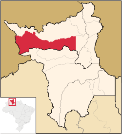 Location in Roraima state | |
 Alto Alegre Location in Brazil | |
| Coordinates: 2°59′16″N 61°18′16″W / 2.98778°N 61.30444°WCoordinates: 2°59′16″N 61°18′16″W / 2.98778°N 61.30444°W | |
| Country |
|
| Region | North Region |
| State | Roraima |
| Area | |
| • Total | 25,567 km2 (9,871 sq mi) |
| Population (2015) | |
| • Total | 16,176 |
| • Density | 0.63/km2 (1.6/sq mi) |
| Time zone | BRT-1 (UTC-4) |
Alto Alegre is a city in the Brazilian state of Roraima. The population in 2015 was 16,176, and the area is 25,567 km².[1] Its limits are Amajari to the north, Boa Vista in the east, Mucajaí and Iracema in the south, and Venezuela in the west.
The municipality contains part of the Roraima National Forest.[2]
 |
Amajari | | ||
| Alto Orinoco (Venezuela) | |
Boa Vista | ||
| ||||
| | ||||
| Iracema Mucajaí |
Mucajaí |
References
- ↑ "IBGE | Cidades | Roraima | Alto Alegre". cidades.ibge.gov.br. Retrieved 2016-06-15.
- ↑ Características da UC (in Portuguese), ICMBio, retrieved 2016-05-19
Capital: Boa Vista | ||
| Boa Vista | 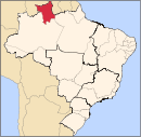 | |
| Nordeste de Roraima | ||
| Caracarai | ||
| Sudeste de Roraima | ||
This article is issued from Wikipedia - version of the 6/15/2016. The text is available under the Creative Commons Attribution/Share Alike but additional terms may apply for the media files.