Amorsolo Street
 | |
| Length | 3.4 km (2.1 mi) |
|---|---|
| Location | Makati |
| North end | Ayala Avenue in Legaspi Village |
| Major junctions |
De La Rosa Street Rufino Street Arnaiz Avenue – – San Lorenzo Village – – Epifanio de los Santos Avenue – – Ecology Village – – |
| South end | Tamarind Road in Dasmariñas Village |
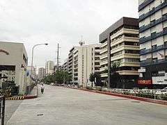
Amorsolo Street is a minor north-south roadway that runs parallel to Chino Roces Avenue in Makati, Metro Manila, Philippines. The street starts inside Barangay Dasmariñas, continues north to San Lorenzo Village with some discontinuities and into the western edge of the Makati Central Business District where it ends at the junction with Ayala Avenue. The street is named for renowned Filipino painter and national artist Fernando Amorsolo.
Route description
The southern end of Amorsolo Street is at Tamarind Road within Barangay Dasmariñas where it serves as the boundary between the gated Dasmariñas and Ecology Village. It is interrupted by the Magallanes Interchange and the MRT line at the intersection with Epifanio de los Santos Avenue (EDSA). On the other side of EDSA, the road picks up as a residential street within San Lorenzo Village where it forms the village's western border running next to a creek. At Arnaiz Avenue, the road leaves the gated village and widens to eight lanes from four with the opening of slightly elevated southbound lanes over the Amorsolo Creek to accommodate increased traffic from the Manila Skyway Makati exit that merges onto the road. The section between Arnaiz Avenue and De La Rosa Street is dominated by old low to mid rise buildings on the eastern side and the Makati Cinema Square and Mile Long complexes on the western side. North of De La Rosa, Amorsolo narrows back to four lanes carrying northbound traffic to its terminus at Ayala Avenue by the Makati Medical Center.
Amorsolo Creek
In 2000, Manila Skyway builder, Citra Metro Manila Tollways Corp., was fined P58.8 million for violating environmental regulations when it covered up the creek in Amorsolo Street and reclaimed the Palili creek in Bicutan. The Department of Environment and Natural Resources attributed the flooding in those areas to the construction of the Skyway on/off ramps on top of those esteros.[1]
Landmarks
- Amorsolo Mansion
- CAP College Foundation Building
- Creekside Amorsolo
- The Columns Legazpi
- Makati Cinema Square (now Makati Square)
- Makati Medical Center
- Medical Plaza
- Mile Long Compound
- NEDA sa Makati Building
- Office of the Solicitor General of the Philippines
- PeopleSupport
- Philippine Tourism Authority now TIEZA
References
- ↑ DENR sanctions Citra for failure to comply with environment rules published by the Philippine Star; accessed 2013-10-16.
Coordinates: 14°33′18″N 121°0′53″E / 14.55500°N 121.01472°E
