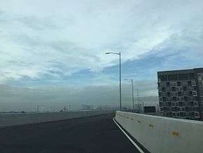
NAIA Expressway
| NAIA Expressway | |
|---|---|
| NAIA Skyway | |
|
The NAIA Expressway in Parañaque (NAIA Terminals 1 & 2–Macapagal Boulevard segment) opened on September 22, 2016 | |
| Route information | |
| Length: | 2.9 km (1.8 mi) |
| Existed: | September 22, 2016 – present |
| Major junctions | |
| From: | Diokno Boulevard, Parañaque |
|
Macapagal Boulevard Manila–Cavite Expressway Quirino Avenue Domestic Road | |
| To: | Ninoy Aquino Avenue and NAIA Road, Pasay |
| Location | |
| Major cities: | |
| Highway system | |
| Highways in the Philippines | |

The NAIA Expressway (NAIAEX, NAIAX and Ninoy Aquino International Airport Expressway)[1] is a 11.6-kilometer (7.2 mi) elevated expressway that runs from the Metro Manila Skyway to Diokno Avenue, and Ninoy Aquino Avenue and NAIA Road near Ninoy Aquino International Airport Terminal 3. This elevated expressway project is divided into 4 packages. This is also the first airport expressway in the Philippines. It is located in Pasay and Parañaque, and a little portion in Taguig.
NAIA Phase II has been proposed. It includes a 7.15-kilometer (4.44 mi) extension of the expressway all the way to Macapagal Boulevard in Entertainment City, Parañaque via Andrews Avenue, Electrical Road (west of Domestic Road) and NAIA Road. Construction begun on 2 January 2014 and was expected to be operational by November 2016.[2][3]
On September 22, 2016 at exactly 12:01 AM (PST), the second phase of the airport expressway from Macapagal Boulevard to NAIA Terminals 1 and 2 has been opened to all motorists and airport passengers rushing to their flights in order to avoid the traffic lights of each intersections along NAIA Road. The opening of the elevated airport expressway was led by Department of Public Works and Highways Secretary Mark Villar. According to Department of Transportation Secretary Arthur Tugade, the toll collection at the NAIAEx will begin on October 22 exactly 1 month after the opening of the airport tollway.[4] By February 2017, the NAIA Road-SLEX-Skyway segment (including the access ramps connecting to Terminal 3) of the airport expressway will be also open.
Technical specifications
- Name: NAIA Expressway or NAIA Skyway
- Concession Holder: Vertex Tollways Development, Inc.
- Operator: Vertex Tollways Development, Inc.
- Concession starting date: 2013
- Concession ending date: 2043
- Length: 11.6 Kilometers
- Highway exits: 8
- Exit ramps: 2 (Villamor, NAIA 3)
- Toll plazas: 1
- Height:
- Spurs: none
Toll

| Class | Toll |
|---|---|
| Class 1 (Cars, Motorcycles, SUVs, Jeepneys) |
₱35.00 |
| Class 2 (Buses, Light Trucks) |
₱69.00 |
| Class 3 (Heavy Trucks) |
₱104.00 |
Exits
Phase 2A
| Location | Kilometer | Destination | Notes | ||||
|---|---|---|---|---|---|---|---|
| Parañaque | Jose Diokno Boulevard | End of expressway | |||||
| Macapagal Boulevard | Eastbound entrance and westbound exit | ||||||
| Manila–Cavite Expressway | Under construction | ||||||
| Parañaque - Pasay boundary | Terminal 3, Newport City, Skyway | Future interchange. | |||||
| Toll plaza | |||||||
| Pasay | Ninoy Aquino Avenue, NAIA Road - Terminals 1/2 | Eastern terminus of expressway | |||||
| 1.000 mi = 1.609 km; 1.000 km = 0.621 mi | |||||||
See also
- Expressways of the Philippines
- Manila-Cavite Expressway
- Metro Manila Skyway
- Ninoy Aquino International Airport
- South Luzon Expressway
References
- ↑ DPWH PPP Projects NAIA
- ↑ NAIA Expressway Phase 2
- ↑ "NAIA Expressway to be operational 2015". BusinessWorld. Retrieved 11 August 2014.
- ↑ "NAIA Expressway finally opening on September 22". ABS-CBN. Retrieved 2016-09-07.
External links
- http://www.gmanews.tv/story/163499/Arroyo-inaugurates-NAIA-expressway-before-leaving-for-Korea Arroyo inaugurates NAIA expressway before leaving for Korea - GMA News report
Coordinates: 14°31′15″N 121°1′21″E / 14.52083°N 121.02250°E
