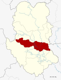
Si Samrong District
| Si Samrong ศรีสำโรง | |
|---|---|
| Amphoe | |
 Amphoe location in Sukhothai Province | |
| Coordinates: 17°9′53″N 99°51′43″E / 17.16472°N 99.86194°ECoordinates: 17°9′53″N 99°51′43″E / 17.16472°N 99.86194°E | |
| Country |
|
| Province | Sukhothai |
| Seat | Khlong Tan |
| Area | |
| • Total | 565.7 km2 (218.4 sq mi) |
| Population (2005) | |
| • Total | 73,810 |
| • Density | 130.5/km2 (338/sq mi) |
| Time zone | THA (UTC+7) |
| Postal code | 64120 |
| Geocode | 6406 |
Si Samrong (Thai: ศรีสำโรง) is a district (Amphoe) of Sukhothai Province, located in the lower north of Thailand.[1][2]
Geography
Neighboring districts are (from the south clockwise) Mueang Sukhothai, Ban Dan Lan Hoi, Thung Saliam and Sawankhalok of Sukhothai Province and Phrom Phiram of Phitsanulok Province.
The important water resource is the Yom River.
History
The district was renamed from Khlong Tan to Si Samrong in 1939.[3]
Administration
The district is subdivided into 13 subdistricts (tambon), which are further subdivided into 137 villages (muban). The township (thesaban tambon) Si Samrong covers the whole tambon Wang Luek and parts of the tambon Khlong Tan and Sam Ruean. There are further 12 Tambon administrative organizations (TAO).
| No. | Name | Thai name | Villages | Inh. | |
|---|---|---|---|---|---|
| 1. | Khlong Tan | คลองตาล | 8 | 7,638 | |
| 2. | Wang Luek | วังลึก | 8 | 4,906 | |
| 2. | Wang Luek | วังลึก | 8 | 764 | |
| 3. | Sam Ruean | สามเรือน | 11 | 7,412 | |
| 4. | Ban Na | บ้านนา | 10 | 2,640 | |
| 5. | Wang Thong | วังทอง | 8 | 4,263 | |
| 6. | Na Khun Krai | นาขุนไกร | 12 | 6,749 | |
| 7. | Ko Ta Liang | เกาะตาเลี้ยง | 14 | 7,369 | |
| 8. | Wat Ko | วัดเกาะ | 11 | 5,031 | |
| 9. | Ban Rai | บ้านไร่ | 10 | 5,532 | |
| 10. | Thap Phueng | ทับผึ้ง | 11 | 9,257 | |
| 11. | Ban San | บ้านซ่าน | 10 | 4,149 | |
| 12. | Wang Yai | วังใหญ่ | 8 | 3,771 | |
| 13. | Rao Ton Chan | ราวต้นจันทร์ | 8 | 4,329 |
References
- ↑ http://www.sukhothai.go.th/3584/data/data_01.htm
- ↑ http://tourisminvest.tat.or.th/en/component/content/article?id=62
- ↑ พระราชกฤษฎีกาเปลี่ยนนามอำเภอ กิ่งอำเภอ และตำบลบางแห่ง พุทธศักราช ๒๔๘๒ (PDF). Royal Gazette (in Thai). 56 (0 ก): 354–364. April 17, 1939.
External links
This article is issued from Wikipedia - version of the 11/3/2016. The text is available under the Creative Commons Attribution/Share Alike but additional terms may apply for the media files.