Andrews, Oregon
| Andrews | |
|---|---|
| Ghost town | |
|
Andrews community school in 2007 | |
 Andrews Location in Oregon | |
| Coordinates: 42°27′51″N 118°36′44″W / 42.46417°N 118.61222°WCoordinates: 42°27′51″N 118°36′44″W / 42.46417°N 118.61222°W | |
| Country | United States |
| State | Oregon |
| County | Harney |
| Elevation | 4,157 ft (1,267 m) |
| Population (as of 1996) | |
| • Total | 0 (ghost town) |
| Time zone | Pacific |
_(harDA0166).jpg)
Andrews is a ghost town in Harney County, Oregon, United States.[1] It is located south of Steens Mountain and near the Alvord Desert.
History
The community was named for Peter Andrews, who settled in the area about 1880.[2] A post office was established on Andrews' property in 1890.[2] The post office was moved north a short distance in 1900 and called "Wildhorse" or "Wild Horse".[2] Locals referred to it as "Wild Hog", however, so the postmaster changed the name to honor his friend Andrews.[2]
The population of Andrews slowly declined until only one house remained. When it burned down in 1996, the community became a ghost town.[2]
Climate
According to the Köppen Climate Classification system, Andrews has a semi-arid climate, abbreviated "BSk" on climate maps.[3]
See also
References
- ↑ "Andrews, Oregon". Geographic Names Information System. United States Geological Survey.
- 1 2 3 4 5 McArthur, Lewis A.; McArthur, Lewis L. (2003) [1928]. Oregon Geographic Names (7th ed.). Portland, Oregon: Oregon Historical Society Press. p. 24. ISBN 978-0875952772.
- ↑ Climate Summary for Andrews, Oregon
External links
- Photo of Andrews school by chipsbuttie
- Historic images of Andrews from Salem Public Library
- Andrews listing on ghosttowns.com
Municipalities and communities of Harney County, Oregon, United States | ||
|---|---|---|
| Cities | 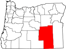 | |
| CDP | ||
| Other unincorporated communities | ||
| Indian reservation | ||
| Ghost town | ||