Diamond, Oregon
| Diamond, Oregon | |
|---|---|
| Unincorporated community | |
|
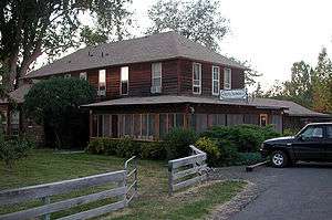
Hotel Diamond | |
 Diamond, Oregon  Diamond, Oregon Location within the state of Oregon | |
| Coordinates: 43°00′44″N 118°39′58″W / 43.01222°N 118.66611°WCoordinates: 43°00′44″N 118°39′58″W / 43.01222°N 118.66611°W | |
| Country | United States |
| State | Oregon |
| County | Harney |
| Elevation | 4,219 ft (1,286 m) |
| Time zone | PST (UTC-8) |
| • Summer (DST) | PDT (UTC-7) |
| ZIP codes | 97722 |
| Area code(s) | 541 |
| Coordinates and elevation from United States Geological Survey[1] | |
Diamond is an unincorporated community in Harney County, Oregon, United States. Diamond is west of Oregon Route 205 and south of Malheur Lake, 52 miles (84 km) south-southeast of Burns by highway.[2] Its post office is assigned ZIP code 97722.[3]
History
Settled in 1874–75, the community got its name from a diamond-shaped branding iron used by a local cattle rancher on the Diamond Ranch.[2] Diamond Craters, the Diamond post office, and other features in the vicinity took their name from the ranch, established in the area by the pioneer settler Mace McCoy. A post office was established at Diamond in 1887.[4]
Another early settler, Minerva J. (Dolly) Kiger, is credited with applying the name of the ranch to the community in 1874.[4] She also named Kiger Creek, which originates on Steens Mountain and enters Swamp Creek near Diamond, and she named two other nearby steams, Cucamonga Creek and McCoy Creek.[4]
Geography
Diamond lies along Swamp Creek at the head of Diamond Valley, northwest of Steens Mountain in southeastern Oregon. Swamp Creek flows into Diamond Swamp, a short distance down the valley. The swamp is part of the Malheur National Wildlife Refuge. Diamond Lane, which runs generally east–west, links the community to Route 205 between Frenchglen to the south and Burns to the north.[5]
Adjacent to the swamp on the east is Diamond Craters, about 6 miles (10 km) northwest of Diamond.[5] This 23-square-mile (60 km2) area of diverse basaltic features is protected as an Outstanding Natural Area, overseen by the Bureau of Land Management.[6]
Climate
According to the Köppen Climate Classification system, Diamond has a semi-arid climate, abbreviated "BSk" on climate maps.[7]
References
- ↑ "Diamond". Geographic Names Information System. United States Geological Survey. November 28, 1980. Retrieved August 24, 2009.
- 1 2 "Community". Harney County Chamber of Commerce. 2014. Retrieved September 1, 2014.
- ↑ "Diamond, Oregon". CD Light. 2014. Retrieved January 4, 2016.
- 1 2 3 McArthur, Lewis A.; McArthur, Lewis L. (2003) [1928]. Oregon Geographic Names (7th ed.). Portland, Oregon: Oregon Historical Society Press. pp. 286, 533–34. ISBN 0-87595-277-1.
- 1 2 "United States Topographic Map". United States Geological Survey. Retrieved January 4, 2016 – via Acme Mapper.
- ↑ "Diamond Craters Outstanding Natural Area". Bureau of Land Management. Retrieved January 4, 2016.
- ↑ "Diamond, Oregon". Weatherbase. CantyMedia. Retrieved January 4, 2016.
Municipalities and communities of Harney County, Oregon, United States | ||
|---|---|---|
| Cities | 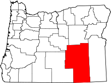 | |
| CDP | ||
| Other unincorporated communities | ||
| Indian reservation | ||
| Ghost town | ||